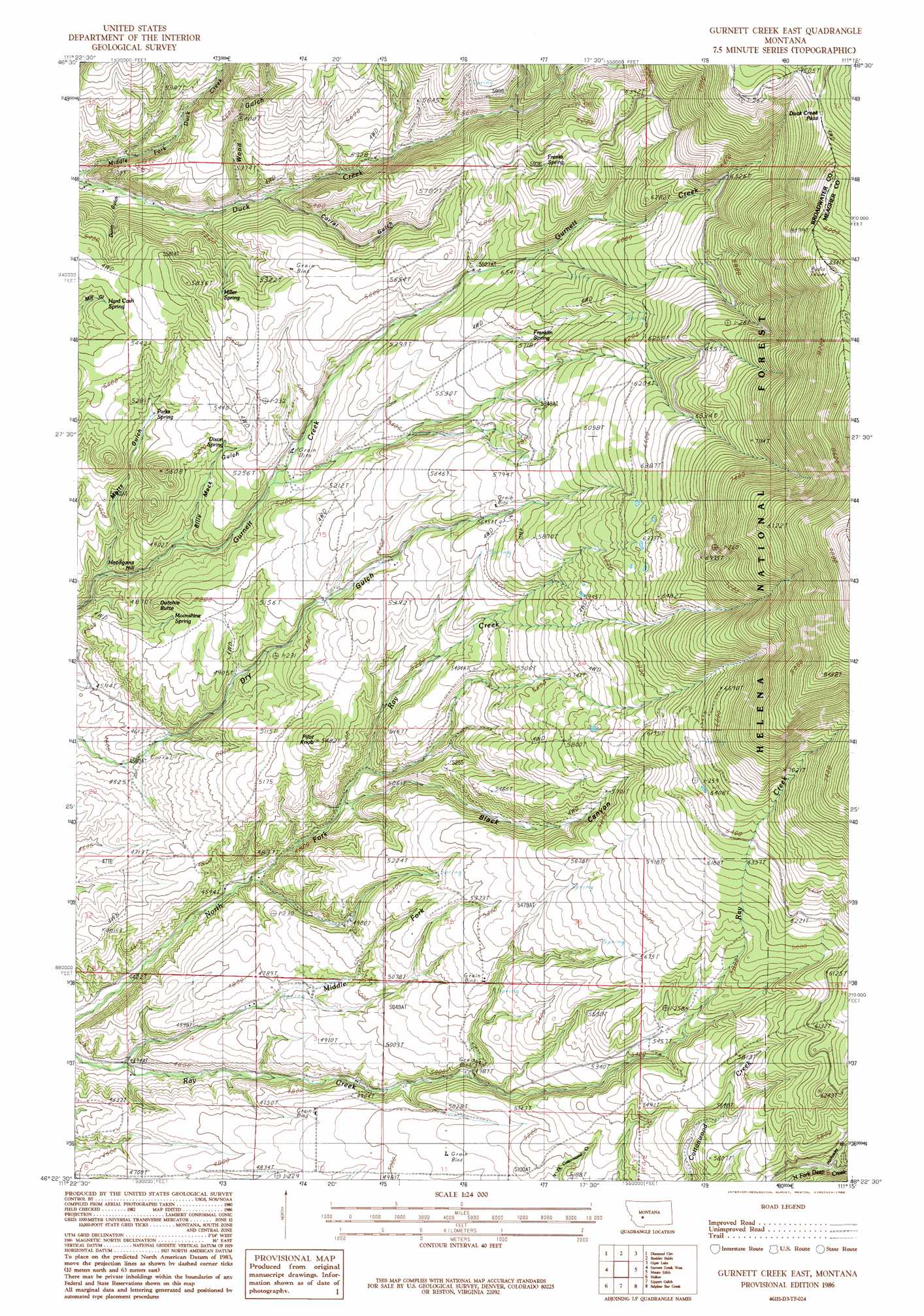
Gurnett Creek East Topo Map Montana
To zoom in, hover over the map of Gurnett Creek East
USGS Topo Quad 46111d3 - 1:24,000 scale
| Topo Map Name: | Gurnett Creek East |
| USGS Topo Quad ID: | 46111d3 |
| Print Size: | ca. 21 1/4" wide x 27" high |
| Southeast Coordinates: | 46.375° N latitude / 111.25° W longitude |
| Map Center Coordinates: | 46.4375° N latitude / 111.3125° W longitude |
| U.S. State: | MT |
| Filename: | o46111d3.jpg |
| Download Map JPG Image: | Gurnett Creek East topo map 1:24,000 scale |
| Map Type: | Topographic |
| Topo Series: | 7.5´ |
| Map Scale: | 1:24,000 |
| Source of Map Images: | United States Geological Survey (USGS) |
| Alternate Map Versions: |
Gurnett Creek East MT 1986, updated 1986 Download PDF Buy paper map Gurnett Creek East MT 2001, updated 2004 Download PDF Buy paper map Gurnett Creek East MT 2011 Download PDF Buy paper map Gurnett Creek East MT 2014 Download PDF Buy paper map |
| FStopo: | US Forest Service topo Gurnett Creek East is available: Download FStopo PDF Download FStopo TIF |
1:24,000 Topo Quads surrounding Gurnett Creek East
Hellgate Gulch |
Whites City |
Watson |
Fort Logan |
Whitetail Reservoir |
Canyon Ferry Se |
Diamond City |
Boulder Baldy |
Gipsy Lake |
Hanson Reservoir |
Townsend Ne |
Gurnett Creek West |
Gurnett Creek East |
Mount Edith |
Alkali Lake |
Townsend |
Holker |
Lippert Gulch |
Sulphur Bar Creek |
Battle Mountain |
Parker |
Toston |
Deer Park |
Sixmile Mountain |
Francis |
> Back to 46111a1 at 1:100,000 scale
> Back to 46110a1 at 1:250,000 scale
> Back to U.S. Topo Maps home
Gurnett Creek East topo map: Gazetteer
Gurnett Creek East: Gaps
Duck Creek Pass elevation 2279m 7477′Gurnett Creek East: Ranges
Big Belt Mountains elevation 2251m 7385′Gurnett Creek East: Springs
Dixon Spring elevation 1586m 5203′Franklin Spring elevation 1753m 5751′
Franks Spring elevation 1845m 6053′
Hard Cash Spring elevation 1635m 5364′
Miller Spring elevation 1665m 5462′
Moonshine Spring elevation 1523m 4996′
Parks Spring elevation 1573m 5160′
Gurnett Creek East: Streams
Middle Fork Ray Creek elevation 1335m 4379′Gurnett Creek East: Summits
Dutchie Butte elevation 1590m 5216′Hooligans Hill elevation 1481m 4858′
Pilot Knob elevation 1673m 5488′
Gurnett Creek East: Trails
Divide Trail elevation 2614m 8576′Gurnett Creek East: Valleys
Billy Mack Gulch elevation 1494m 4901′Black Canyon elevation 1459m 4786′
Corral Gulch elevation 1546m 5072′
Dunn Gulch elevation 1480m 4855′
Holloway Gulch elevation 1690m 5544′
Matts Gulch elevation 1439m 4721′
Wood Gulch elevation 1561m 5121′
Gurnett Creek East digital topo map on disk
Buy this Gurnett Creek East topo map showing relief, roads, GPS coordinates and other geographical features, as a high-resolution digital map file on DVD: