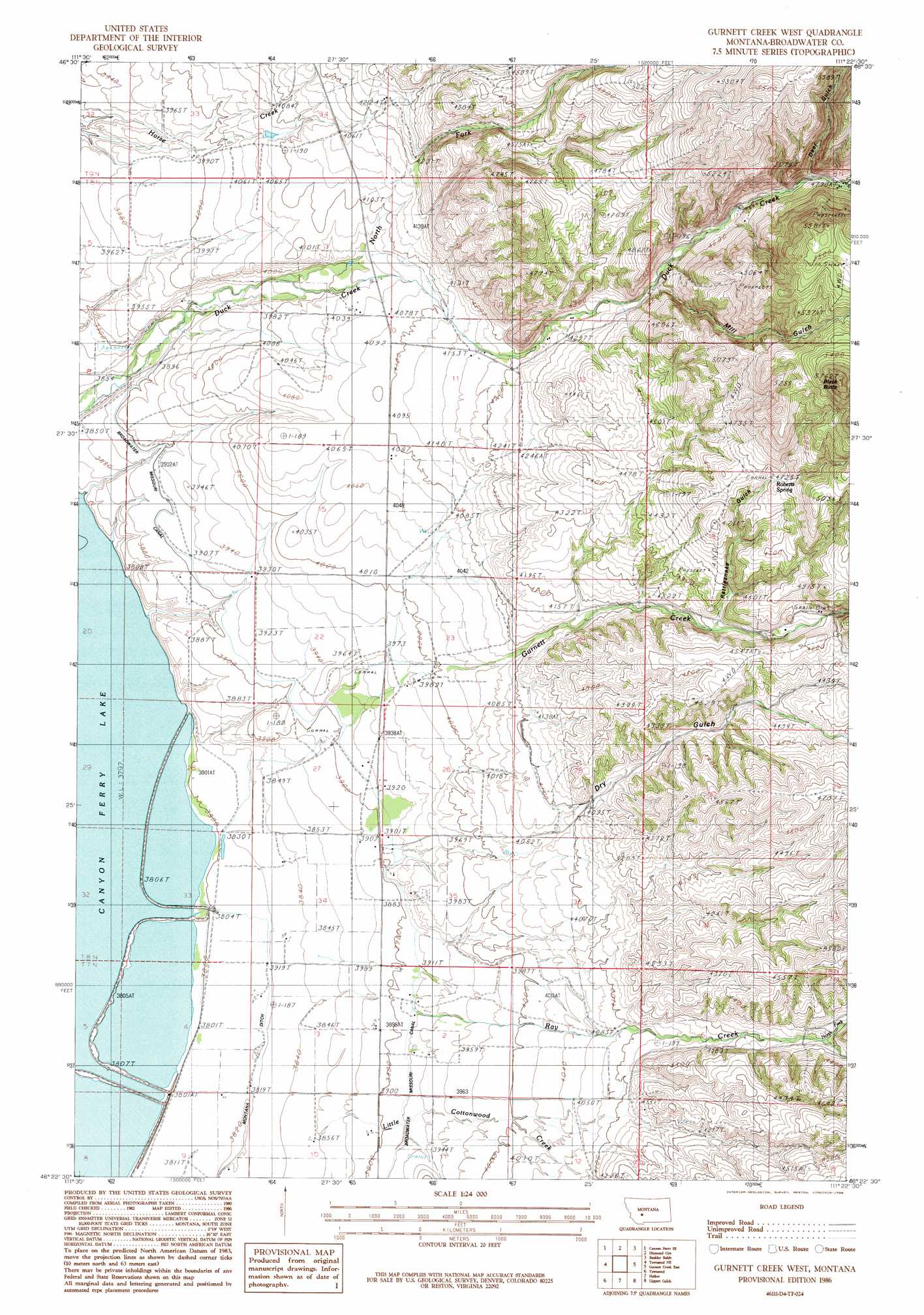
Gurnett Creek West Topo Map Montana
To zoom in, hover over the map of Gurnett Creek West
USGS Topo Quad 46111d4 - 1:24,000 scale
| Topo Map Name: | Gurnett Creek West |
| USGS Topo Quad ID: | 46111d4 |
| Print Size: | ca. 21 1/4" wide x 27" high |
| Southeast Coordinates: | 46.375° N latitude / 111.375° W longitude |
| Map Center Coordinates: | 46.4375° N latitude / 111.4375° W longitude |
| U.S. State: | MT |
| Filename: | o46111d4.jpg |
| Download Map JPG Image: | Gurnett Creek West topo map 1:24,000 scale |
| Map Type: | Topographic |
| Topo Series: | 7.5´ |
| Map Scale: | 1:24,000 |
| Source of Map Images: | United States Geological Survey (USGS) |
| Alternate Map Versions: |
Gurnett Creek West MT 1986, updated 1986 Download PDF Buy paper map Gurnett Creek West MT 2011 Download PDF Buy paper map Gurnett Creek West MT 2014 Download PDF Buy paper map |
1:24,000 Topo Quads surrounding Gurnett Creek West
Canyon Ferry |
Hellgate Gulch |
Whites City |
Watson |
Fort Logan |
Canyon Ferry Sw |
Canyon Ferry Se |
Diamond City |
Boulder Baldy |
Gipsy Lake |
Winston |
Townsend Ne |
Gurnett Creek West |
Gurnett Creek East |
Mount Edith |
Giant Hill |
Townsend |
Holker |
Lippert Gulch |
Sulphur Bar Creek |
Radersburg |
Parker |
Toston |
Deer Park |
Sixmile Mountain |
> Back to 46111a1 at 1:100,000 scale
> Back to 46110a1 at 1:250,000 scale
> Back to U.S. Topo Maps home
Gurnett Creek West topo map: Gazetteer
Gurnett Creek West: Canals
Broadwater Missouri Canal elevation 1190m 3904′Highland Ditch elevation 1257m 4124′
Irish Ditch elevation 1159m 3802′
Montana Ditch elevation 1165m 3822′
Yankee Ditch elevation 1158m 3799′
Gurnett Creek West: Dams
Duck Fields Dam elevation 1249m 4097′Gurnett Creek West: Mines
NE NW Section 5 Mine elevation 1592m 5223′NW SE Section 5 Mine elevation 1668m 5472′
NW SE Section 6 Mine elevation 1576m 5170′
Gurnett Creek West: Springs
07N02E02BB__01 Spring elevation 1190m 3904′07N02E02CA__01 Spring elevation 1202m 3943′
Roberts Spring elevation 1441m 4727′
Gurnett Creek West: Streams
Gurnett Creek elevation 1162m 3812′Little Cottonwood Creek elevation 1177m 3861′
Middle Fork Duck Creek elevation 1451m 4760′
North Fork Ray Creek elevation 1298m 4258′
Ray Creek elevation 1240m 4068′
Gurnett Creek West: Summits
Black Butte elevation 1751m 5744′Gurnett Creek West: Valleys
Dry Gulch elevation 1240m 4068′Mill Gulch elevation 1443m 4734′
Rattlesnake Gulch elevation 1325m 4347′
Gurnett Creek West: Wells
07N02E02BD__01 Well elevation 1198m 3930′07N02E03AD__01 Well elevation 1184m 3884′
07N02E03ADDA01 Well elevation 1186m 3891′
07N02E03BC__01 Well elevation 1165m 3822′
07N02E03BC__02 Well elevation 1165m 3822′
07N02E03BCBA01 Well elevation 1164m 3818′
07N02E03CB__01 Well elevation 1165m 3822′
07N02E04AA__01 Well elevation 1162m 3812′
07N02E04AB__01 Well elevation 1159m 3802′
07N02E04AD__01 Well elevation 1162m 3812′
07N02E04AD__02 Well elevation 1162m 3812′
07N02E04BA__01 Well elevation 1158m 3799′
07N02E04BA__02 Well elevation 1158m 3799′
07N02E04BA__03 Well elevation 1158m 3799′
07N02E04BA__04 Well elevation 1158m 3799′
07N02E04CD__01 Well elevation 1158m 3799′
07N02E04CD__02 Well elevation 1158m 3799′
07N02E04DB__01 Well elevation 1160m 3805′
07N02E04DD__01 Well elevation 1163m 3815′
07N02E04DD__02 Well elevation 1163m 3815′
07N02E04DD__03 Well elevation 1163m 3815′
07N02E08AA__01 Well elevation 1158m 3799′
07N02E08AD__01 Well elevation 1158m 3799′
07N02E08AD__02 Well elevation 1158m 3799′
07N02E08AD__03 Well elevation 1158m 3799′
07N02E09AA__01 Well elevation 1164m 3818′
07N02E09AABB01 Well elevation 1163m 3815′
07N02E09AB__01 Well elevation 1162m 3812′
07N02E09AC__01 Well elevation 1163m 3815′
07N02E09AC__02 Well elevation 1163m 3815′
07N02E09BA__01 Well elevation 1159m 3802′
07N02E09BA__02 Well elevation 1159m 3802′
07N02E09BA__03 Well elevation 1159m 3802′
07N02E09CA__01 Well elevation 1161m 3809′
07N02E09DA__01 Well elevation 1165m 3822′
07N02E09DB__01 Well elevation 1164m 3818′
07N02E10AD__01 Well elevation 1186m 3891′
07N02E10BB__01 Well elevation 1168m 3832′
07N02E10BD__01 Well elevation 1174m 3851′
07N02E10DA__01 Well elevation 1188m 3897′
08N02E03DC__01 Well elevation 1218m 3996′
08N02E03DC__02 Well elevation 1218m 3996′
08N02E03DD__01 Well elevation 1235m 4051′
08N02E09BC__01 Well elevation 1178m 3864′
08N02E10AA__01 Well elevation 1241m 4071′
08N02E11AB__01 Well elevation 1261m 4137′
08N02E14BB__01 Well elevation 1249m 4097′
08N02E14BBBC01 Well elevation 1247m 4091′
08N02E20AA__01 Well elevation 1158m 3799′
08N02E21CA__01 Well elevation 1179m 3868′
08N02E21CD__01 Well elevation 1158m 3799′
08N02E23CBBA01 Well elevation 1213m 3979′
08N02E23CC__01 Well elevation 1209m 3966′
08N02E23CC__02 Well elevation 1209m 3966′
08N02E23CC__03 Well elevation 1209m 3966′
08N02E28AC__01 Well elevation 1162m 3812′
08N02E28AC__02 Well elevation 1162m 3812′
08N02E28CB__01 Well elevation 1158m 3799′
08N02E28CD__01 Well elevation 1158m 3799′
08N02E29AD__01 Well elevation 1158m 3799′
08N02E29DD__01 Well elevation 1158m 3799′
08N02E29DD__02 Well elevation 1158m 3799′
08N02E32AA__01 Well elevation 1158m 3799′
08N02E33BC__01 Well elevation 1158m 3799′
08N02E33BC__02 Well elevation 1158m 3799′
08N02E33BC__03 Well elevation 1158m 3799′
08N02E33DA__01 Well elevation 1162m 3812′
08N02E33DB__01 Well elevation 1159m 3802′
08N02E33DB__02 Well elevation 1159m 3802′
08N02E33DB__03 Well elevation 1159m 3802′
08N02E34BA__01 Well elevation 1173m 3848′
08N02E34CB__01 Well elevation 1165m 3822′
08N02E34CD__01 Well elevation 1171m 3841′
08N02E35BCDD01 Well elevation 1199m 3933′
08N03E30AA__01 Well elevation 1364m 4475′
08N03E30AA__02 Well elevation 1364m 4475′
09N02E33CD__01 Well elevation 1217m 3992′
09N02E34DAAA01 Well elevation 1283m 4209′
Gurnett Creek West digital topo map on disk
Buy this Gurnett Creek West topo map showing relief, roads, GPS coordinates and other geographical features, as a high-resolution digital map file on DVD: