Fort Logan Topo Map Montana
To zoom in, hover over the map of Fort Logan
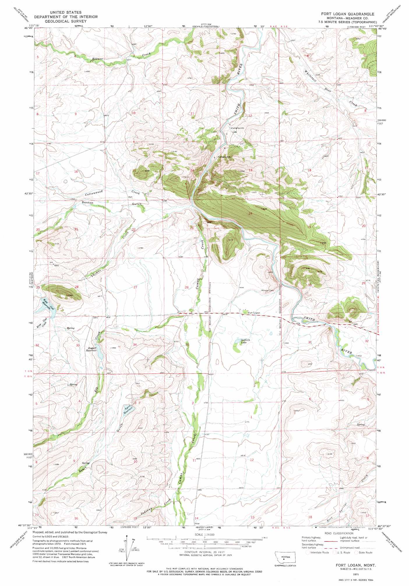
USGS Topo Quad 46111f2 - 1:24,000 scale
| Topo Map Name: | Fort Logan |
| USGS Topo Quad ID: | 46111f2 |
| Print Size: | ca. 21 1/4" wide x 27" high |
| Southeast Coordinates: | 46.625° N latitude / 111.125° W longitude |
| Map Center Coordinates: | 46.6875° N latitude / 111.1875° W longitude |
| U.S. State: | MT |
| Filename: | o46111f2.jpg |
| Download Map JPG Image: | Fort Logan topo map 1:24,000 scale |
| Map Type: | Topographic |
| Topo Series: | 7.5´ |
| Map Scale: | 1:24,000 |
| Source of Map Images: | United States Geological Survey (USGS) |
| Alternate Map Versions: |
Fort Logan MT 1971, updated 1975 Download PDF Buy paper map Fort Logan MT 1995, updated 1997 Download PDF Buy paper map Fort Logan MT 2011 Download PDF Buy paper map Fort Logan MT 2014 Download PDF Buy paper map |
| FStopo: | US Forest Service topo Fort Logan is available: Download FStopo PDF Download FStopo TIF |
1:24,000 Topo Quads surrounding Fort Logan
Lingshire Nw |
Lingshire Ne |
Bald Hills |
Monument Peak |
Bubbling Springs |
Lingshire |
Ellis Canyon |
Devils Footstool |
Sheep Mountain |
Strawberry Butte |
Whites City |
Watson |
Fort Logan |
Whitetail Reservoir |
Coxcombe Butte |
Diamond City |
Boulder Baldy |
Gipsy Lake |
Hanson Reservoir |
White Sulphur Springs |
Gurnett Creek West |
Gurnett Creek East |
Mount Edith |
Alkali Lake |
Catlin Spring |
> Back to 46111e1 at 1:100,000 scale
> Back to 46110a1 at 1:250,000 scale
> Back to U.S. Topo Maps home
Fort Logan topo map: Gazetteer
Fort Logan: Dams
Ayers Dam elevation 1523m 4996′Dogget Lake Dam elevation 1440m 4724′
Keep Cool Dam elevation 1467m 4812′
Fort Logan: Lakes
Soldiers Lake elevation 1420m 4658′Fort Logan: Populated Places
Fort Logan elevation 1414m 4639′Fort Logan: Post Offices
Fort Logan Post Office (historical) elevation 1414m 4639′Lewis Post Office (historical) elevation 1393m 4570′
Fort Logan: Reservoirs
Ayers Reservoir elevation 1526m 5006′Doggett Reservoir elevation 1496m 4908′
Keep Cool Reservoir elevation 1466m 4809′
Fort Logan: Streams
Camas Creek elevation 1396m 4580′Cottonwood Creek elevation 1387m 4550′
Elk Creek elevation 1441m 4727′
Indiana Creek elevation 1487m 4878′
Keep Cool Creek elevation 1450m 4757′
Spring Creek elevation 1422m 4665′
Thomas Creek elevation 1385m 4543′
Fort Logan: Valleys
Ayers Gulch elevation 1452m 4763′Benton Gulch elevation 1390m 4560′
Fort Logan: Wells
11N04E25C___01 Well elevation 1415m 4642′11N04E26DC__01 Well elevation 1417m 4648′
11N05E18DB__01 Well elevation 1464m 4803′
11N05E19AB__01 Well elevation 1470m 4822′
11N05E20C___01 Well elevation 1450m 4757′
11N05E32BA__01 Well elevation 1425m 4675′
11N05E32BC__01 Well elevation 1408m 4619′
Fort Logan digital topo map on disk
Buy this Fort Logan topo map showing relief, roads, GPS coordinates and other geographical features, as a high-resolution digital map file on DVD: