Boulder East Topo Map Montana
To zoom in, hover over the map of Boulder East
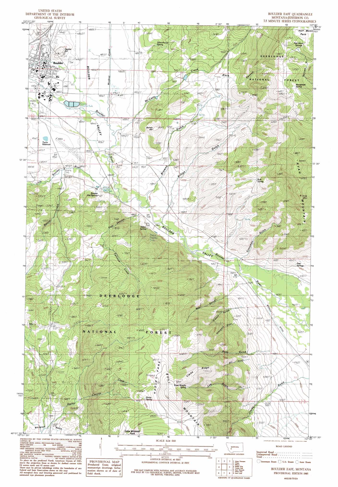
USGS Topo Quad 46112b1 - 1:24,000 scale
| Topo Map Name: | Boulder East |
| USGS Topo Quad ID: | 46112b1 |
| Print Size: | ca. 21 1/4" wide x 27" high |
| Southeast Coordinates: | 46.125° N latitude / 112° W longitude |
| Map Center Coordinates: | 46.1875° N latitude / 112.0625° W longitude |
| U.S. State: | MT |
| Filename: | o46112b1.jpg |
| Download Map JPG Image: | Boulder East topo map 1:24,000 scale |
| Map Type: | Topographic |
| Topo Series: | 7.5´ |
| Map Scale: | 1:24,000 |
| Source of Map Images: | United States Geological Survey (USGS) |
| Alternate Map Versions: |
Boulder East MT 1985, updated 1986 Download PDF Buy paper map Boulder East MT 1996, updated 1998 Download PDF Buy paper map Boulder East MT 2011 Download PDF Buy paper map Boulder East MT 2014 Download PDF Buy paper map |
| FStopo: | US Forest Service topo Boulder East is available: Download FStopo PDF Download FStopo TIF |
1:24,000 Topo Quads surrounding Boulder East
Three Brothers |
Chessman Reservoir |
Jefferson City |
Clancy |
Casey Peak |
Basin |
Mount Thompson |
Wickes |
Elkhorn |
Crow Creek Falls |
Bison Canyon |
Boulder West |
Boulder East |
Tacoma Park |
Devils Fence |
Whitetail Peak |
Ratio Mountain |
Wilson Park |
Dunn Creek |
Willow Springs |
Delmoe Lake |
Dry Mountain |
Black Butte |
Doherty Mountain |
Negro Hollow |
> Back to 46112a1 at 1:100,000 scale
> Back to 46112a1 at 1:250,000 scale
> Back to U.S. Topo Maps home
Boulder East topo map: Gazetteer
Boulder East: Airports
Boulder Airport elevation 1499m 4917′Boulder East: Bridges
Boulder River Bridge elevation 1471m 4826′Boulder East: Crossings
Interchange 164 elevation 1523m 4996′Boulder East: Flats
Hadley Park elevation 2129m 6984′Half Moon Park elevation 2107m 6912′
Boulder East: Mines
Chinese Diggins elevation 1487m 4878′Boulder East: Parks
Boulder River Bridge Historical Marker elevation 1471m 4826′Boulder East: Populated Places
Boulder elevation 1496m 4908′Sunset Trailer Court elevation 1495m 4904′
Boulder East: Post Offices
Boulder Post Office elevation 1496m 4908′Boulder East: Reservoirs
Taylor Reservoir elevation 1510m 4954′Boulder East: Ridges
Clarke Ridge elevation 2141m 7024′Boulder East: Springs
05N03W10CBAC01 Spring elevation 1489m 4885′05N04W10CAB_01 Spring elevation 1487m 4878′
05N04W10CACB01 Spring elevation 1487m 4878′
05N04W10CACB02 Spring elevation 1487m 4878′
05N04W10CACB03 Spring elevation 1487m 4878′
05N04W10CACB04 Spring elevation 1487m 4878′
05N04W16DCA_01 Spring elevation 1659m 5442′
Burt Spring elevation 1684m 5524′
Half Moon Springs elevation 2039m 6689′
Manganese Spring elevation 1994m 6541′
Pete Springs elevation 1493m 4898′
Rocky Spring elevation 2077m 6814′
Rosie Murphy Spring elevation 2098m 6883′
Schoolhouse Spring elevation 1534m 5032′
Boulder East: Streams
Beaver Creek elevation 1470m 4822′Farnham Creek elevation 1453m 4767′
Little Boulder River elevation 1460m 4790′
McCarty Creek elevation 1474m 4835′
Muskrat Creek elevation 1459m 4786′
Rocky Canyon Creek elevation 1682m 5518′
Boulder East: Summits
Bonan Hill elevation 1657m 5436′Capital Hill elevation 1550m 5085′
Ryan Mountain elevation 2090m 6856′
Boulder East: Valleys
Black Canyon elevation 1631m 5351′Browns Gulch elevation 1501m 4924′
Crazyman Gulch elevation 1445m 4740′
Dry Gulch elevation 1603m 5259′
Gibson Gulch elevation 1487m 4878′
Goat Canyon elevation 1457m 4780′
Killian Gulch elevation 1474m 4835′
Log Gulch elevation 1434m 4704′
Rear Gulch elevation 1440m 4724′
Ryan Gulch elevation 1434m 4704′
Widemouth Gulch elevation 1436m 4711′
Boulder East: Wells
05N03W18CDCD01 Well elevation 1442m 4730′05N04W03AAAA01 Well elevation 1490m 4888′
05N04W10BCCB01 Well elevation 1479m 4852′
06N04W28DADD01 Well elevation 1486m 4875′
06N04W28DADD02 Well elevation 1486m 4875′
06N04W28DCAB01 Well elevation 1502m 4927′
06N04W32AABD01 Well elevation 1495m 4904′
06N04W33BAAD01 Well elevation 1492m 4895′
06N04W33BABD01 Well elevation 1493m 4898′
06N04W33CCBD01 Well elevation 1494m 4901′
06N04W33CCCC01 Well elevation 1495m 4904′
Boulder East digital topo map on disk
Buy this Boulder East topo map showing relief, roads, GPS coordinates and other geographical features, as a high-resolution digital map file on DVD: