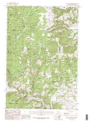
Mount Thompson Topo Map Montana
To zoom in, hover over the map of Mount Thompson
USGS Topo Quad 46112c2 - 1:24,000 scale
| Topo Map Name: | Mount Thompson |
| USGS Topo Quad ID: | 46112c2 |
| Print Size: | ca. 21 1/4" wide x 27" high |
| Southeast Coordinates: | 46.25° N latitude / 112.125° W longitude |
| Map Center Coordinates: | 46.3125° N latitude / 112.1875° W longitude |
| U.S. State: | MT |
| Filename: | o46112c2.jpg |
| Download Map JPG Image: | Mount Thompson topo map 1:24,000 scale |
| Map Type: | Topographic |
| Topo Series: | 7.5´ |
| Map Scale: | 1:24,000 |
| Source of Map Images: | United States Geological Survey (USGS) |
| Alternate Map Versions: |
Mount Thompson MT 1985, updated 1986 Download PDF Buy paper map Mount Thompson MT 1985, updated 1986 Download PDF Buy paper map Mount Thompson MT 1996, updated 1998 Download PDF Buy paper map Mount Thompson MT 2011 Download PDF Buy paper map Mount Thompson MT 2014 Download PDF Buy paper map |
| FStopo: | US Forest Service topo Mount Thompson is available: Download FStopo PDF Download FStopo TIF |
1:24,000 Topo Quads surrounding Mount Thompson
> Back to 46112a1 at 1:100,000 scale
> Back to 46112a1 at 1:250,000 scale
> Back to U.S. Topo Maps home
Mount Thompson topo map: Gazetteer
Mount Thompson: Crossings
Interchange 160 elevation 1555m 5101′Mount Thompson: Flats
Bluebird Flats elevation 2279m 7477′Boulder Chief Park elevation 2313m 7588′
Locker Flats elevation 1974m 6476′
Mount Thompson: Mines
Australian Mine elevation 1920m 6299′Ba Ka Maa Mine elevation 2225m 7299′
Baltimore Mine elevation 1783m 5849′
Bluebird Mine elevation 2143m 7030′
Bluebird Mine elevation 2152m 7060′
Bluestone Mine elevation 1831m 6007′
Boston Mine elevation 1869m 6131′
Boulder Chief Mine elevation 2281m 7483′
Boulder Chief Mine elevation 2342m 7683′
Boulder Vestal Mine elevation 1803m 5915′
Buckeye Mine elevation 1922m 6305′
California Mine elevation 1872m 6141′
Cataract Mine elevation 1971m 6466′
Clipper/Edna Mine elevation 2013m 6604′
Comet Tailings elevation 2001m 6564′
Comet/Rumley Mine elevation 1962m 6437′
Crawley Camp Mine elevation 1975m 6479′
Custer/Hiawatha Mine elevation 2099m 6886′
Deer Lodge Mine elevation 1881m 6171′
Denver Mine elevation 1787m 5862′
Eva May Mine elevation 2081m 6827′
Eva May Mine elevation 1997m 6551′
Free Enterprise Mine elevation 1681m 5515′
Galena Mine elevation 2051m 6729′
Gray Eagle Mine elevation 2021m 6630′
Grey Eagle Mine elevation 2013m 6604′
Hattie Ferguson Mine elevation 2113m 6932′
Hattie Ferguson Mine elevation 1975m 6479′
Hawkeye Mine elevation 1957m 6420′
Hiawatha Mine elevation 2011m 6597′
Ida M Mine elevation 2209m 7247′
Lizzie Osborne Mine elevation 2096m 6876′
Mantle East Mine elevation 1775m 5823′
Mantle Mine elevation 1763m 5784′
Middle Snowdrift Creek Mine elevation 2138m 7014′
Mina Mine elevation 1933m 6341′
Minah Mine elevation 1913m 6276′
Mineapolis Mine elevation 1906m 6253′
Morning Glory Mine elevation 1980m 6496′
Morning Glory Mine elevation 1945m 6381′
Mount Thompson Mine elevation 2164m 7099′
Mountain Chief Mine elevation 2168m 7112′
NE NE Section 13 Mine elevation 2060m 6758′
NE NE Section 15 Mine elevation 1674m 5492′
NE NW Section 16 elevation 2172m 7125′
NE NW Section 3 Mine elevation 2089m 6853′
NE SE Section 15 Mine elevation 1648m 5406′
NE SW Section 1 Mine elevation 1929m 6328′
New Cottage Mine elevation 1851m 6072′
NW SE Section 15 Mine elevation 1811m 5941′
NW SW Section 36 Mine elevation 2024m 6640′
Pen Yan Mine elevation 2287m 7503′
Placer 2313 Mine elevation 1647m 5403′
Redemption Mine elevation 2167m 7109′
Rochester Mine elevation 1973m 6473′
S B Junior Mine elevation 1822m 5977′
Salvail Mine elevation 1790m 5872′
SE SW Section 28 Mine elevation 2019m 6624′
Self - Riser Mine elevation 1989m 6525′
Silver King Mine elevation 2013m 6604′
Stair Mine elevation 1996m 6548′
SW NE Section 15 Mine elevation 1816m 5958′
SW NW Section 28 Mine elevation 1985m 6512′
SW SW Section 1 Mine elevation 1900m 6233′
Vera Marie Mine elevation 1962m 6437′
Washington Mine elevation 1833m 6013′
Washington Mines elevation 1797m 5895′
West Mount Thompson Mine elevation 2250m 7381′
Will Parkinson Mine elevation 1970m 6463′
Mount Thompson: Populated Places
Comet elevation 1947m 6387′Fuller elevation 1558m 5111′
Glenbeg (historical) elevation 1831m 6007′
Mount Thompson: Post Offices
Cataract Post Office (historical) elevation 1603m 5259′Comet Post Office (historical) elevation 1947m 6387′
Glenbeg Post Office (historical) elevation 1831m 6007′
Mount Thompson: Streams
Bishop Creek elevation 1817m 5961′Cataract Creek elevation 1602m 5255′
High Ore Creek elevation 1559m 5114′
Hoodoo Creek elevation 1992m 6535′
Luddy Creek elevation 2089m 6853′
Rocker Creek elevation 2062m 6765′
Snowdrift Creek elevation 2047m 6715′
Mount Thompson: Summits
Mount Thompson elevation 2415m 7923′Sugarloaf Mountain elevation 2038m 6686′
Mount Thompson: Valleys
Big Limber Gulch elevation 1696m 5564′Boomerang Gulch elevation 1561m 5121′
Buttermilk Jim Gulch elevation 1584m 5196′
Curtain Gulch elevation 1810m 5938′
Galena Gulch elevation 1546m 5072′
Little Galena Gulch elevation 1539m 5049′
McKenzie Gulch elevation 1752m 5748′
Uncle Sam Gulch elevation 1914m 6279′
Mount Thompson: Wells
07N04W08DBDA01 Well elevation 1713m 5620′Mount Thompson digital topo map on disk
Buy this Mount Thompson topo map showing relief, roads, GPS coordinates and other geographical features, as a high-resolution digital map file on DVD:


