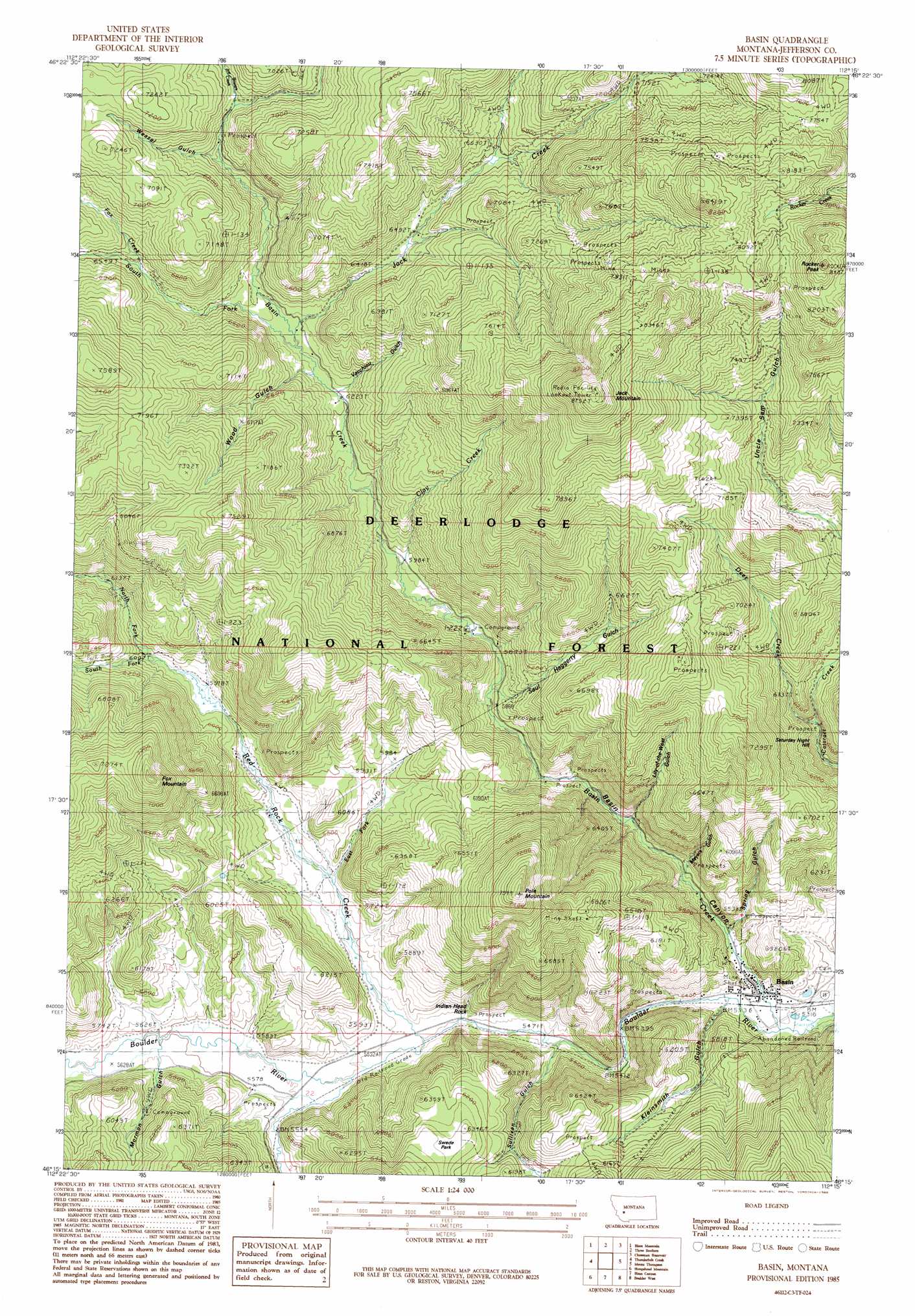
Basin Topo Map Montana
To zoom in, hover over the map of Basin
USGS Topo Quad 46112c3 - 1:24,000 scale
| Topo Map Name: | Basin |
| USGS Topo Quad ID: | 46112c3 |
| Print Size: | ca. 21 1/4" wide x 27" high |
| Southeast Coordinates: | 46.25° N latitude / 112.25° W longitude |
| Map Center Coordinates: | 46.3125° N latitude / 112.3125° W longitude |
| U.S. State: | MT |
| Filename: | o46112c3.jpg |
| Download Map JPG Image: | Basin topo map 1:24,000 scale |
| Map Type: | Topographic |
| Topo Series: | 7.5´ |
| Map Scale: | 1:24,000 |
| Source of Map Images: | United States Geological Survey (USGS) |
| Alternate Map Versions: |
Basin MT 1985, updated 1986 Download PDF Buy paper map Basin MT 1985, updated 1986 Download PDF Buy paper map Basin MT 1996, updated 1998 Download PDF Buy paper map Basin MT 2011 Download PDF Buy paper map Basin MT 2014 Download PDF Buy paper map |
| FStopo: | US Forest Service topo Basin is available: Download FStopo PDF Download FStopo TIF |
1:24,000 Topo Quads surrounding Basin
Avon |
Elliston |
Macdonald Pass |
Black Mountain |
Helena |
Baggs Creek |
Bison Mountain |
Three Brothers |
Chessman Reservoir |
Jefferson City |
Sugarloaf Mountain |
Thunderbolt Creek |
Basin |
Mount Thompson |
Wickes |
Lockhart Meadows |
Sheepshead Mountain |
Bison Canyon |
Boulder West |
Boulder East |
Butte North |
Elk Park Pass |
Whitetail Peak |
Ratio Mountain |
Wilson Park |
> Back to 46112a1 at 1:100,000 scale
> Back to 46112a1 at 1:250,000 scale
> Back to U.S. Topo Maps home
Basin topo map: Gazetteer
Basin: Airports
Klies Air Strip elevation 1915m 6282′Basin: Crossings
Interchange 151 elevation 1694m 5557′Interchange 156 elevation 1621m 5318′
Basin: Flats
Swede Park elevation 1912m 6272′Basin: Lakes
Frog Pond elevation 1835m 6020′Basin: Mines
Aurora Mine elevation 1832m 6010′Aurora Mine elevation 1794m 5885′
Basin Millsite elevation 1639m 5377′
Bauernfeind Mine elevation 1722m 5649′
Binghampton Mine elevation 2426m 7959′
Blubell Health Mine elevation 1690m 5544′
Bluebell Health Mine elevation 1721m 5646′
Boulder Mine elevation 2063m 6768′
Bullion Mine elevation 2207m 7240′
Bullion Mine elevation 2256m 7401′
Crystal Mine elevation 2482m 8143′
Crystal Mine elevation 2312m 7585′
Doris Mine elevation 1683m 5521′
Eureka Mine elevation 1675m 5495′
Evening Star Mine elevation 2014m 6607′
First Shot Mine elevation 2487m 8159′
Garfiel Extension Mine elevation 1984m 6509′
Hector Mine elevation 1957m 6420′
Helper Mine elevation 1750m 5741′
Helper Mine elevation 1761m 5777′
Hope Mine elevation 1631m 5351′
Indian Head Rock Mine elevation 1729m 5672′
Jack Creek Tailings elevation 1988m 6522′
James/Holland/Alpine Mine elevation 2480m 8136′
Mammoth/Crystal Mine elevation 2439m 8001′
Marey An Mine elevation 2464m 8083′
Marguerite Mine elevation 2208m 7244′
Marguerite Mine elevation 2160m 7086′
Meyers Gulch Mine elevation 1658m 5439′
Moccason Mine elevation 2446m 8024′
Morning Mine elevation 2446m 8024′
Morning Mine elevation 2423m 7949′
NE Basin Mine elevation 1708m 5603′
NE NE Section 13 Mine elevation 2273m 7457′
NW NE Section 32 Mine elevation 1696m 5564′
NW SW Section 29 Mine elevation 2066m 6778′
NW SW Section 7 Mine elevation 2229m 7312′
Red Rock Mine elevation 1823m 5980′
SE SW Section 32 Mine elevation 1628m 5341′
Sparkling Water Mine elevation 2355m 7726′
SW NE Section 32 Mine elevation 1672m 5485′
SW NW Section 29 Mine elevation 2082m 6830′
SW SE Section 1 Mine elevation 1750m 5741′
SW SE Section 13 Mine elevation 1658m 5439′
SW SE Section 29 Mine elevation 2158m 7080′
White Pine/Custer Mine elevation 1957m 6420′
Winters Camp Mine elevation 2033m 6669′
Basin: Parks
Mining Country Historical Marker elevation 1635m 5364′Basin: Pillars
Indian Head Rock elevation 1730m 5675′Basin: Populated Places
Basin elevation 1635m 5364′Bernice elevation 1692m 5551′
Basin: Post Offices
Basin Post Office elevation 1635m 5364′Bernice Post Office (historical) elevation 1692m 5551′
Basin: Streams
Basin Creek elevation 1623m 5324′Bison Creek elevation 1683m 5521′
Clay Creek elevation 1822m 5977′
Deer Creek elevation 1799m 5902′
East Fork Red Rock Creek elevation 1726m 5662′
Fox Creek elevation 1986m 6515′
Jack Creek elevation 1907m 6256′
Joe Bowers Creek elevation 2030m 6660′
North Fork Red Rock Creek elevation 1815m 5954′
Red Rock Creek elevation 1671m 5482′
South Fork Basin Creek elevation 1912m 6272′
South Fork Red Rock Creek elevation 1823m 5980′
Basin: Summits
Fox Mountain elevation 2264m 7427′Jack Mountain elevation 2660m 8727′
Pole Mountain elevation 2311m 7582′
Rocker Peak elevation 2577m 8454′
Saturday Night Hill elevation 2086m 6843′
Basin: Valleys
Basin Canyon elevation 1621m 5318′Kleinsmith Gulch elevation 1673m 5488′
Lily of the West Gulch elevation 1728m 5669′
Meyers Gulch elevation 1661m 5449′
Mormon Gulch elevation 1710m 5610′
Retort Gulch elevation 1672m 5485′
Saul Haggerty Gulch elevation 1785m 5856′
Spring Gulch elevation 1668m 5472′
Sullivan Gulch elevation 1684m 5524′
Vacchiou Gulch elevation 1899m 6230′
Weasel Gulch elevation 2016m 6614′
Wood Gulch elevation 1917m 6289′
Basin digital topo map on disk
Buy this Basin topo map showing relief, roads, GPS coordinates and other geographical features, as a high-resolution digital map file on DVD: