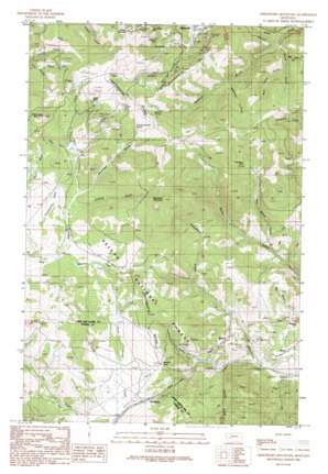
Greenhorn Mountain Topo Map Montana
To zoom in, hover over the map of Greenhorn Mountain
USGS Topo Quad 46112f3 - 1:24,000 scale
| Topo Map Name: | Greenhorn Mountain |
| USGS Topo Quad ID: | 46112f3 |
| Print Size: | ca. 21 1/4" wide x 27" high |
| Southeast Coordinates: | 46.625° N latitude / 112.25° W longitude |
| Map Center Coordinates: | 46.6875° N latitude / 112.3125° W longitude |
| U.S. State: | MT |
| Filename: | o46112f3.jpg |
| Download Map JPG Image: | Greenhorn Mountain topo map 1:24,000 scale |
| Map Type: | Topographic |
| Topo Series: | 7.5´ |
| Map Scale: | 1:24,000 |
| Source of Map Images: | United States Geological Survey (USGS) |
| Alternate Map Versions: |
Greenhorn Mountain MT 1989, updated 1989 Download PDF Buy paper map Greenhorn Mountain MT 2001, updated 2004 Download PDF Buy paper map Greenhorn Mountain MT 2011 Download PDF Buy paper map Greenhorn Mountain MT 2014 Download PDF Buy paper map |
| FStopo: | US Forest Service topo Greenhorn Mountain is available: Download FStopo PDF Download FStopo TIF |
1:24,000 Topo Quads surrounding Greenhorn Mountain
> Back to 46112e1 at 1:100,000 scale
> Back to 46112a1 at 1:250,000 scale
> Back to U.S. Topo Maps home
Greenhorn Mountain topo map: Gazetteer
Greenhorn Mountain: Flats
Thompson Flats elevation 1880m 6167′Greenhorn Mountain: Gaps
Mullan Pass elevation 1808m 5931′Greenhorn Mountain: Lakes
Beaver Ponds elevation 1804m 5918′Beaver Ponds elevation 1786m 5859′
Greenhorn Mountain: Mines
Albion Mine elevation 1990m 6528′Allegheny Mine elevation 1987m 6519′
Ample/Hickey Mine elevation 2047m 6715′
Bald Butte Millsite elevation 1890m 6200′
Bald Mountain Mine elevation 1968m 6456′
Bald Mountain Mine elevation 1971m 6466′
Belmont Mine elevation 1892m 6207′
Belmont Mine elevation 1932m 6338′
Black Douglas Mine elevation 2127m 6978′
Black Hawk/Janette Mine elevation 2050m 6725′
Devon/Sterling Mine elevation 1961m 6433′
Drumlummon Millsite elevation 1789m 5869′
Drumlummon Mine elevation 1762m 5780′
East NW Section 5 Mine elevation 1615m 5298′
Emma Miller Mine elevation 1914m 6279′
Fraction Mine elevation 1739m 5705′
Fresno Mine elevation 1837m 6026′
Genesee Mine elevation 2112m 6929′
Goldsil Millsite elevation 1665m 5462′
Good Luck Mine elevation 1686m 5531′
Griff Mine elevation 1995m 6545′
Kenawa Mine elevation 2030m 6660′
Larson Mine elevation 1848m 6062′
Limestone Ridge Mine elevation 1615m 5298′
Little Valley Mine elevation 1615m 5298′
Neenan Mine elevation 2025m 6643′
Nine-Hour Mine elevation 1867m 6125′
NW NE Section 10 Mine elevation 2069m 6788′
NW NE Section 2 Mine elevation 1893m 6210′
Penobscot Mine elevation 2008m 6587′
Robert Emmet Mine elevation 1801m 5908′
Rose Bud Mine elevation 2100m 6889′
Rose Densmore Mine elevation 1842m 6043′
SE SW Section 33 Mine elevation 1942m 6371′
SE SW Section 36 Mine elevation 1673m 5488′
Shannon Mine elevation 2074m 6804′
Shannon Mine elevation 2034m 6673′
Silver Creek Mine elevation 1877m 6158′
Snow Bird Mine elevation 2087m 6847′
Strawberry Mine elevation 1819m 5967′
Strawberry Mine elevation 1824m 5984′
Summit Mine elevation 1945m 6381′
SW NE Section 4 Mine elevation 2005m 6578′
SW SW Section 32 Mine elevation 1518m 4980′
Wild Cat Mine elevation 1802m 5912′
Greenhorn Mountain: Populated Places
Bald Butte elevation 1990m 6528′Belmont (historical) elevation 1819m 5967′
Blossburg elevation 1696m 5564′
Skyline elevation 1623m 5324′
Weed elevation 1533m 5029′
Greenhorn Mountain: Post Offices
Baldbutte Post Office (historical) elevation 1990m 6528′Belmont Post Office (historical) elevation 1819m 5967′
Blossburg Post Office (historical) elevation 1696m 5564′
Greenwood Post Office (historical) elevation 1835m 6020′
Mullan Post Office (historical) elevation 1807m 5928′
Greenhorn Mountain: Springs
11N06W04BDD_01 Spring elevation 1931m 6335′11N06W04DDC_01 Spring elevation 2008m 6587′
11N06W10BBC_01 Spring elevation 1997m 6551′
11N06W16AAB_01 Spring elevation 1869m 6131′
12N06W32DAB_01 Spring elevation 1779m 5836′
American Gulch Spring elevation 1898m 6227′
Sawmill Spring elevation 1902m 6240′
Greenhorn Mountain: Streams
Austin Creek elevation 1475m 4839′Granite Creek elevation 1547m 5075′
Meadow Creek elevation 1769m 5803′
Greenhorn Mountain: Summits
Bald Butte elevation 2132m 6994′Drumlummon Hill elevation 1921m 6302′
Greenhorn Mountain elevation 2289m 7509′
Mount Belmont elevation 2232m 7322′
Roundtop Mountain elevation 2108m 6916′
Greenhorn Mountain: Tunnels
Mullan Tunnel elevation 1777m 5830′Greenhorn Mountain: Valleys
American Gulch elevation 1810m 5938′China Gulch elevation 1487m 4878′
Dago Gulch elevation 1851m 6072′
East China Gulch elevation 1512m 4960′
East Skelly Gulch elevation 1582m 5190′
Eldorado Gulch elevation 1619m 5311′
Friday Gulch elevation 1744m 5721′
LaSalle Gulch elevation 1814m 5951′
Ottawa Gulch elevation 1696m 5564′
Rawhide Gulch elevation 1693m 5554′
Sawmill Gulch elevation 1451m 4760′
Towsley Gulch elevation 1726m 5662′
West China Gulch elevation 1557m 5108′
Woodchopper Gulch elevation 1864m 6115′
Greenhorn Mountain: Wells
10N05W05CDBA01 Well elevation 1516m 4973′12N06W36CABD01 Well elevation 1640m 5380′
Greenhorn Mountain digital topo map on disk
Buy this Greenhorn Mountain topo map showing relief, roads, GPS coordinates and other geographical features, as a high-resolution digital map file on DVD:


