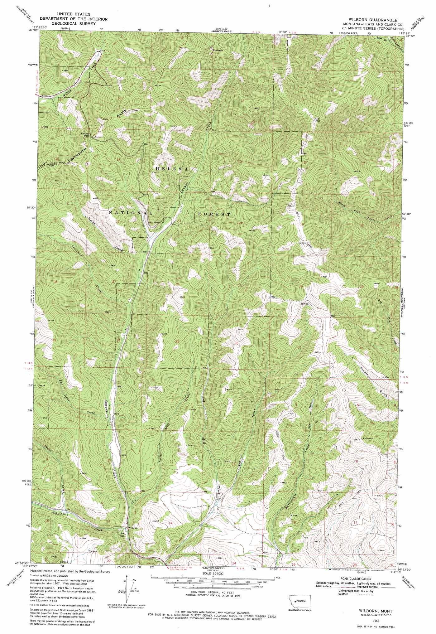
Wilborn Topo Map Montana
To zoom in, hover over the map of Wilborn
USGS Topo Quad 46112h3 - 1:24,000 scale
| Topo Map Name: | Wilborn |
| USGS Topo Quad ID: | 46112h3 |
| Print Size: | ca. 21 1/4" wide x 27" high |
| Southeast Coordinates: | 46.875° N latitude / 112.25° W longitude |
| Map Center Coordinates: | 46.9375° N latitude / 112.3125° W longitude |
| U.S. State: | MT |
| Filename: | o46112h3.jpg |
| Download Map JPG Image: | Wilborn topo map 1:24,000 scale |
| Map Type: | Topographic |
| Topo Series: | 7.5´ |
| Map Scale: | 1:24,000 |
| Source of Map Images: | United States Geological Survey (USGS) |
| Alternate Map Versions: |
Wilborn MT 1968, updated 1971 Download PDF Buy paper map Wilborn MT 2001, updated 2004 Download PDF Buy paper map Wilborn MT 2011 Download PDF Buy paper map Wilborn MT 2014 Download PDF Buy paper map |
| FStopo: | US Forest Service topo Wilborn is available: Download FStopo PDF Download FStopo TIF |
1:24,000 Topo Quads surrounding Wilborn
Caribou Peak |
Blowout Mountain |
Johnson Mountain |
Comb Rock |
Coburn Mountain |
Silver King Mountain |
Cadotte Creek |
Rogers Pass |
Roberts Mountain |
Wolf Creek |
Swede Gulch |
Stemple Pass |
Wilborn |
Mitchell Mountain |
Sheep Creek |
Nevada Mountain |
Granite Butte |
Canyon Creek |
Silver City |
Rattlesnake Mountain |
Ophir Creek |
Esmeralda Hill |
Greenhorn Mountain |
Austin |
Scratchgravel Hill |
> Back to 46112e1 at 1:100,000 scale
> Back to 46112a1 at 1:250,000 scale
> Back to U.S. Topo Maps home
Wilborn topo map: Gazetteer
Wilborn: Gaps
Flesher Pass elevation 1871m 6138′Wilborn: Populated Places
Strom elevation 1466m 4809′Wilborn elevation 1417m 4648′
Wilborn: Post Offices
Wilborn Post Office (historical) elevation 1417m 4648′Wilborn: Streams
Little Mill Creek elevation 1427m 4681′Specimen Creek elevation 1516m 4973′
Tar Head Creek elevation 1461m 4793′
Trout Creek elevation 1442m 4730′
Virginia Creek elevation 1412m 4632′
Weino Creek elevation 1537m 5042′
Wilborn: Valleys
Bear Gulch elevation 1402m 4599′Sawmill Gulch elevation 1459m 4786′
Wilborn digital topo map on disk
Buy this Wilborn topo map showing relief, roads, GPS coordinates and other geographical features, as a high-resolution digital map file on DVD: