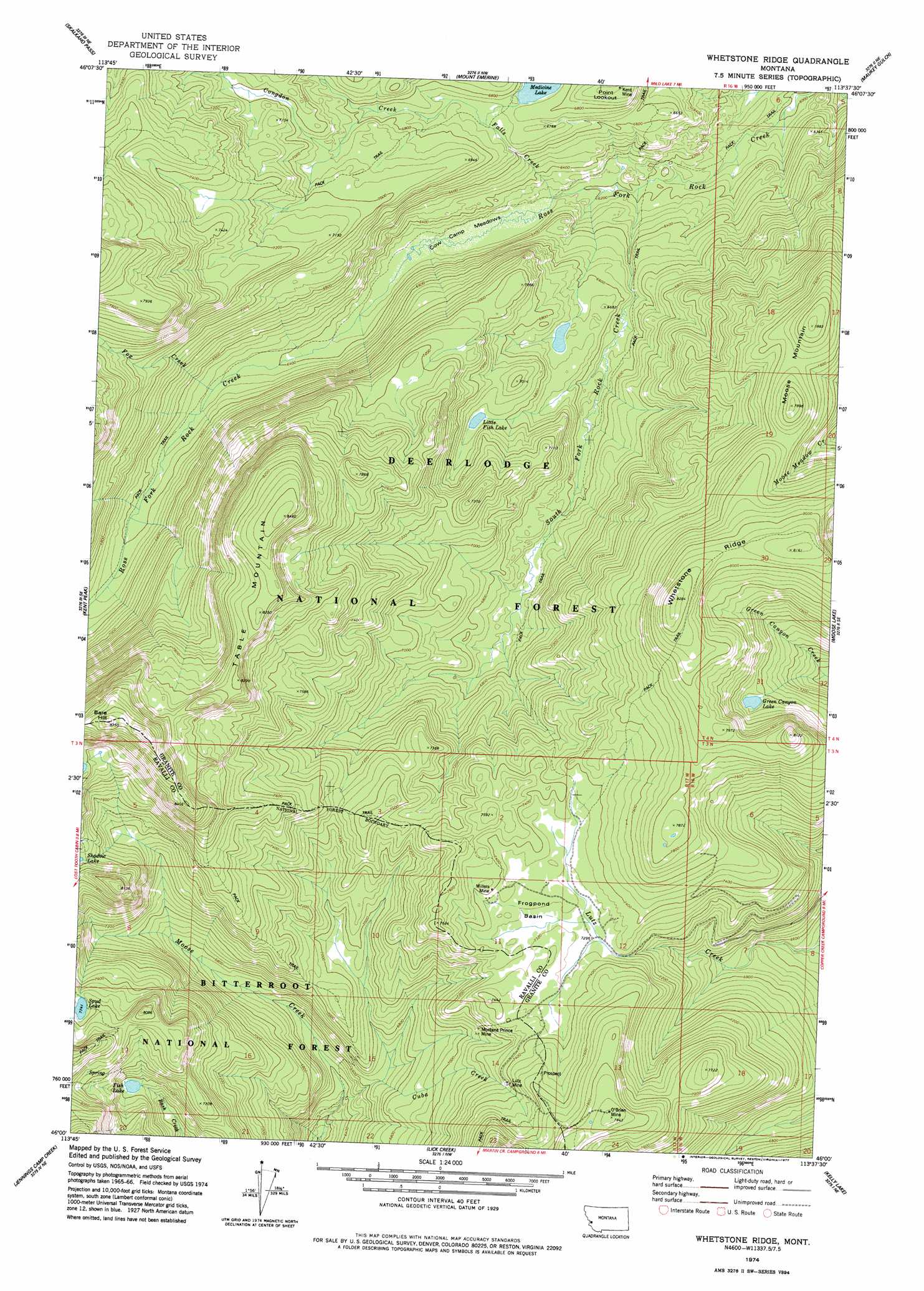
Whetstone Ridge Topo Map Montana
To zoom in, hover over the map of Whetstone Ridge
USGS Topo Quad 46113a6 - 1:24,000 scale
| Topo Map Name: | Whetstone Ridge |
| USGS Topo Quad ID: | 46113a6 |
| Print Size: | ca. 21 1/4" wide x 27" high |
| Southeast Coordinates: | 46° N latitude / 113.625° W longitude |
| Map Center Coordinates: | 46.0625° N latitude / 113.6875° W longitude |
| U.S. State: | MT |
| Filename: | o46113a6.jpg |
| Download Map JPG Image: | Whetstone Ridge topo map 1:24,000 scale |
| Map Type: | Topographic |
| Topo Series: | 7.5´ |
| Map Scale: | 1:24,000 |
| Source of Map Images: | United States Geological Survey (USGS) |
| Alternate Map Versions: |
Whetstone Ridge MT 1974, updated 1977 Download PDF Buy paper map Whetstone Ridge MT 1996, updated 1998 Download PDF Buy paper map Whetstone Ridge MT 2011 Download PDF Buy paper map Whetstone Ridge MT 2014 Download PDF Buy paper map |
| FStopo: | US Forest Service topo Whetstone Ridge is available: Download FStopo PDF Download FStopo TIF |
1:24,000 Topo Quads surrounding Whetstone Ridge
Willow Mountain |
Burnt Fork Lake |
Stony Creek |
Cornish Gulch |
Antelope Creek |
Gird Point |
Skalkaho Pass |
Mount Emerine |
Maukey Gulch |
Potato Lakes |
Bald Top Mountain |
Kent Peak |
Whetstone Ridge |
Moose Lake |
Carpp Ridge |
French Basin |
Jennings Camp Creek |
Lick Creek |
Kelly Lake |
Warren Peak |
Sula |
Schultz Saddle |
Bender Point |
Mussigbrod Lake |
Pintlar Lake |
> Back to 46113a1 at 1:100,000 scale
> Back to 46112a1 at 1:250,000 scale
> Back to U.S. Topo Maps home
Whetstone Ridge topo map: Gazetteer
Whetstone Ridge: Basins
Frogpond Basin elevation 2232m 7322′Whetstone Ridge: Capes
Point Lookout elevation 2122m 6961′Whetstone Ridge: Flats
Cow Camp Meadows elevation 1913m 6276′Whetstone Ridge: Lakes
Fish Lake elevation 2251m 7385′Green Canyon Lake elevation 2264m 7427′
Little Fish Lake elevation 2080m 6824′
Whetstone Ridge: Mines
Kent Mine elevation 2123m 6965′Lutz Mine elevation 2236m 7335′
Lutz Mine elevation 2242m 7355′
Miller Mine elevation 2262m 7421′
Millers Mine elevation 2262m 7421′
Montana Prince Mine elevation 2181m 7155′
Montana Prince Mine elevation 2168m 7112′
NE SE Section 14 Mine elevation 2300m 7545′
O'Brien Mine elevation 2419m 7936′
O'Brien Mine elevation 2380m 7808′
Whetstone Ridge: Ridges
Whetstone Ridge elevation 2467m 8093′Whetstone Ridge: Streams
Cuba Creek elevation 1928m 6325′Falls Creek elevation 1905m 6250′
Fox Creek elevation 1969m 6459′
South Fork Rock Creek elevation 1883m 6177′
Whetstone Ridge: Summits
Bare Hill elevation 2667m 8750′Moose Mountain elevation 2407m 7896′
Table Mountain elevation 2577m 8454′
Whetstone Ridge digital topo map on disk
Buy this Whetstone Ridge topo map showing relief, roads, GPS coordinates and other geographical features, as a high-resolution digital map file on DVD: