West Valley Topo Map Montana
To zoom in, hover over the map of West Valley
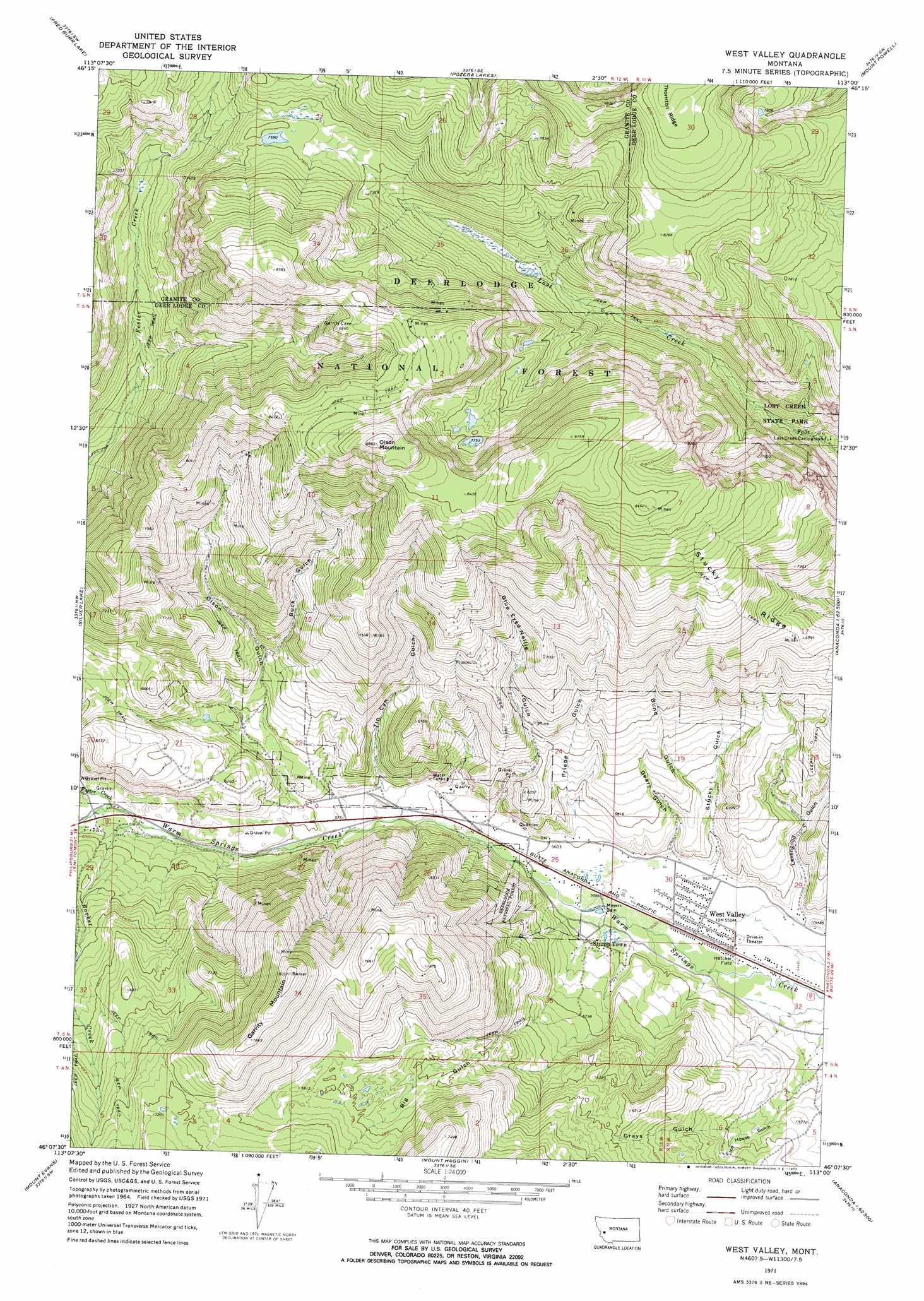
USGS Topo Quad 46113b1 - 1:24,000 scale
| Topo Map Name: | West Valley |
| USGS Topo Quad ID: | 46113b1 |
| Print Size: | ca. 21 1/4" wide x 27" high |
| Southeast Coordinates: | 46.125° N latitude / 113° W longitude |
| Map Center Coordinates: | 46.1875° N latitude / 113.0625° W longitude |
| U.S. State: | MT |
| Filename: | o46113b1.jpg |
| Download Map JPG Image: | West Valley topo map 1:24,000 scale |
| Map Type: | Topographic |
| Topo Series: | 7.5´ |
| Map Scale: | 1:24,000 |
| Source of Map Images: | United States Geological Survey (USGS) |
| Alternate Map Versions: |
West Valley MT 1971, updated 1973 Download PDF Buy paper map West Valley MT 1971, updated 1973 Download PDF Buy paper map West Valley MT 1996, updated 1998 Download PDF Buy paper map West Valley MT 2011 Download PDF Buy paper map West Valley MT 2014 Download PDF Buy paper map |
| FStopo: | US Forest Service topo West Valley is available: Download FStopo PDF Download FStopo TIF |
1:24,000 Topo Quads surrounding West Valley
Henderson Mountain |
Maxville |
Pikes Peak |
Rock Creek Lake |
Conleys Lake |
Philipsburg |
Fred Burr Lake |
Pozega Lakes |
Mount Powell |
Racetrack |
Georgetown Lake |
Silver Lake |
West Valley |
Anaconda North |
Warm Springs |
Storm Lake |
Mount Evans |
Mount Haggin |
Anaconda South |
Opportunity |
Long Peak |
Lower Seymour Lake |
Lincoln Gulch |
Dickie Peak |
Burnt Mountain |
> Back to 46113a1 at 1:100,000 scale
> Back to 46112a1 at 1:250,000 scale
> Back to U.S. Topo Maps home
West Valley topo map: Gazetteer
West Valley: Dams
Meyers Dam elevation 1697m 5567′Meyers Dam elevation 1695m 5561′
West Valley: Flats
Hatcher Field elevation 1669m 5475′West Valley: Mines
Balkan Mine elevation 1868m 6128′Blue Eyed Nellie Mine elevation 2103m 6899′
Blue Eyed Nellie Mine elevation 2099m 6886′
Buck Gulch Mine elevation 2217m 7273′
George Mines elevation 2533m 8310′
Gladstone Mine elevation 2064m 6771′
Homestake Mine elevation 2432m 7979′
Keystone Mine elevation 2432m 7979′
Mohawk Mine elevation 1946m 6384′
Mountain View Mine elevation 2177m 7142′
NW NE Section 2 Mine elevation 2588m 8490′
NW NE Section 36 Mine elevation 2355m 7726′
NW NW Section 2 Mine elevation 2566m 8418′
NW NW Section 25 Mine elevation 1780m 5839′
SE NE Section 14 Mine elevation 2249m 7378′
SE NW Section 24 Mine elevation 1890m 6200′
SE NW Section 26 Mine elevation 1943m 6374′
SE SW Section 22 Mine elevation 1791m 5875′
Sheridan Mine elevation 1982m 6502′
SW NW Section 10 Mine elevation 2451m 8041′
SW SW Section 21 Mine elevation 1978m 6489′
SW SW Section 27 Mine elevation 2025m 6643′
West Valley: Parks
Lost Creek State Park elevation 1958m 6423′West Valley: Populated Places
Stump Town elevation 1705m 5593′West Valley elevation 1678m 5505′
West Valley: Streams
Barker Creek elevation 1788m 5866′Foster Creek elevation 1794m 5885′
West Valley: Summits
Garrity Mountain elevation 2452m 8044′Olson Mountain elevation 2702m 8864′
West Valley: Valleys
Big Gulch elevation 1692m 5551′Blue Eyed Nellie Gulch elevation 1732m 5682′
Buck Gulch elevation 1886m 6187′
Bund Gulch elevation 1733m 5685′
English Gulch elevation 1671m 5482′
Geary Gulch elevation 1703m 5587′
Grays Gulch elevation 1742m 5715′
Ice House Gulch elevation 1659m 5442′
Levengood Gulch elevation 1680m 5511′
Olson Gulch elevation 1765m 5790′
Priebe Gulch elevation 1714m 5623′
Stucky Gulch elevation 1692m 5551′
Tin Can Gulch elevation 1764m 5787′
West Valley: Wells
05N11W29DCDA01 Well elevation 1673m 5488′05N11W30DDCA01 Well elevation 1674m 5492′
West Valley digital topo map on disk
Buy this West Valley topo map showing relief, roads, GPS coordinates and other geographical features, as a high-resolution digital map file on DVD: