Georgetown Lake Topo Map Montana
To zoom in, hover over the map of Georgetown Lake
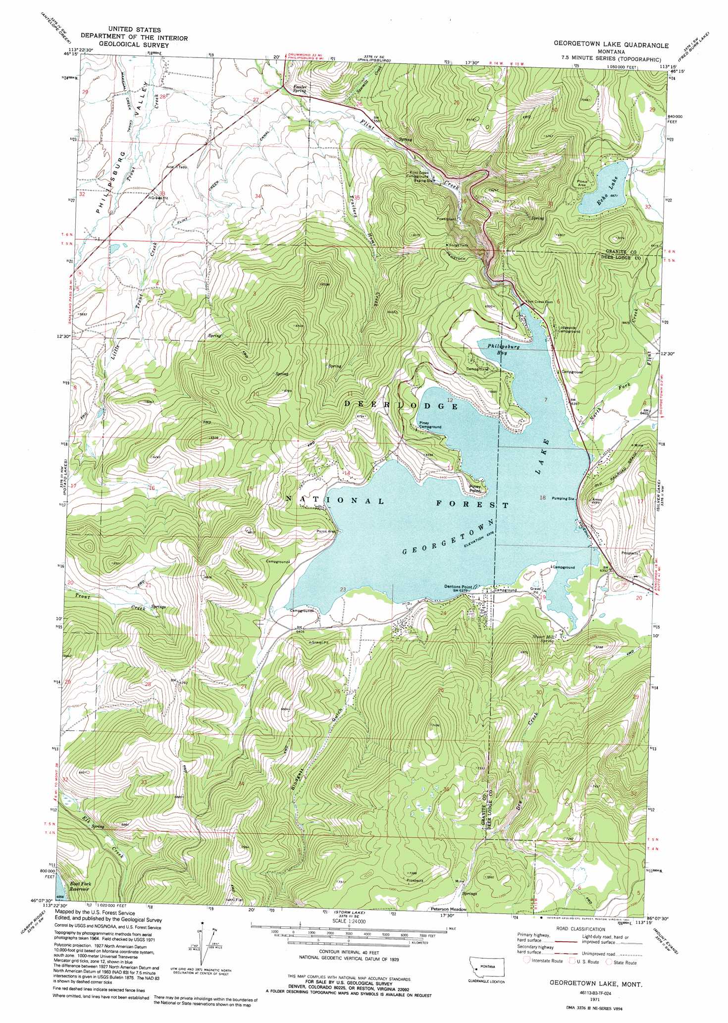
USGS Topo Quad 46113b3 - 1:24,000 scale
| Topo Map Name: | Georgetown Lake |
| USGS Topo Quad ID: | 46113b3 |
| Print Size: | ca. 21 1/4" wide x 27" high |
| Southeast Coordinates: | 46.125° N latitude / 113.25° W longitude |
| Map Center Coordinates: | 46.1875° N latitude / 113.3125° W longitude |
| U.S. State: | MT |
| Filename: | o46113b3.jpg |
| Download Map JPG Image: | Georgetown Lake topo map 1:24,000 scale |
| Map Type: | Topographic |
| Topo Series: | 7.5´ |
| Map Scale: | 1:24,000 |
| Source of Map Images: | United States Geological Survey (USGS) |
| Alternate Map Versions: |
Georgetown Lake MT 1971, updated 1973 Download PDF Buy paper map Georgetown Lake MT 1971, updated 1991 Download PDF Buy paper map Georgetown Lake MT 1996, updated 1998 Download PDF Buy paper map Georgetown Lake MT 2011 Download PDF Buy paper map Georgetown Lake MT 2014 Download PDF Buy paper map |
| FStopo: | US Forest Service topo Georgetown Lake is available: Download FStopo PDF Download FStopo TIF |
1:24,000 Topo Quads surrounding Georgetown Lake
Alder Gulch |
Black Pine Ridge |
Henderson Mountain |
Maxville |
Pikes Peak |
Cornish Gulch |
Antelope Creek |
Philipsburg |
Fred Burr Lake |
Pozega Lakes |
Maukey Gulch |
Potato Lakes |
Georgetown Lake |
Silver Lake |
West Valley |
Moose Lake |
Carpp Ridge |
Storm Lake |
Mount Evans |
Mount Haggin |
Kelly Lake |
Warren Peak |
Long Peak |
Lower Seymour Lake |
Lincoln Gulch |
> Back to 46113a1 at 1:100,000 scale
> Back to 46112a1 at 1:250,000 scale
> Back to U.S. Topo Maps home
Georgetown Lake topo map: Gazetteer
Georgetown Lake: Bays
Philipsburg Bay elevation 1945m 6381′Georgetown Lake: Capes
Dentons Point elevation 1945m 6381′Piney Point elevation 1962m 6437′
Georgetown Lake: Dams
Flint Creek Dam elevation 1941m 6368′Georgetown Lake Dam elevation 1952m 6404′
Georgetown Lake: Flats
Peterson Meadow elevation 2166m 7106′Georgetown Lake: Lakes
Echo Lake elevation 2035m 6676′Georgetown Lake: Mines
Lost Track Mine elevation 1945m 6381′Twilight Mine elevation 1971m 6466′
Georgetown Lake: Populated Places
Echo Lake (historical) elevation 2062m 6765′Georgetown Lake: Reservoirs
Georgetown Lake elevation 1939m 6361′Georgetown Lake: Springs
Fessler Spring elevation 1659m 5442′Stuart Mill Spring elevation 1953m 6407′
Georgetown Lake: Streams
Dry Creek elevation 1961m 6433′Little Trout Creek elevation 1634m 5360′
North Fork Flint Creek elevation 1947m 6387′
Sawmill Creek elevation 1671m 5482′
Travlers Home Creek elevation 1678m 5505′
Georgetown Lake: Valleys
Blodgett Gulch elevation 1958m 6423′Georgetown Lake digital topo map on disk
Buy this Georgetown Lake topo map showing relief, roads, GPS coordinates and other geographical features, as a high-resolution digital map file on DVD: