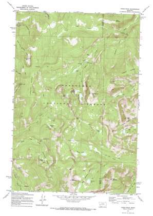
Pikes Peak Topo Map Montana
To zoom in, hover over the map of Pikes Peak
USGS Topo Quad 46113d1 - 1:24,000 scale
| Topo Map Name: | Pikes Peak |
| USGS Topo Quad ID: | 46113d1 |
| Print Size: | ca. 21 1/4" wide x 27" high |
| Southeast Coordinates: | 46.375° N latitude / 113° W longitude |
| Map Center Coordinates: | 46.4375° N latitude / 113.0625° W longitude |
| U.S. State: | MT |
| Filename: | o46113d1.jpg |
| Download Map JPG Image: | Pikes Peak topo map 1:24,000 scale |
| Map Type: | Topographic |
| Topo Series: | 7.5´ |
| Map Scale: | 1:24,000 |
| Source of Map Images: | United States Geological Survey (USGS) |
| Alternate Map Versions: |
Pikes Peak MT 1971, updated 1973 Download PDF Buy paper map Pikes Peak MT 1971, updated 1986 Download PDF Buy paper map Pikes Peak MT 1996, updated 1998 Download PDF Buy paper map Pikes Peak MT 2011 Download PDF Buy paper map Pikes Peak MT 2014 Download PDF Buy paper map |
| FStopo: | US Forest Service topo Pikes Peak is available: Download FStopo PDF Download FStopo TIF |
1:24,000 Topo Quads surrounding Pikes Peak
> Back to 46113a1 at 1:100,000 scale
> Back to 46112a1 at 1:250,000 scale
> Back to U.S. Topo Maps home
Pikes Peak topo map: Gazetteer
Pikes Peak: Basins
Deerlodge Basin elevation 2330m 7644′Horseshoe Basin elevation 2125m 6971′
Pikes Peak: Dams
Gold Lake Dam elevation 2213m 7260′Pikes Peak: Gaps
Game Pass elevation 2462m 8077′Pikes Peak: Lakes
Altoona Lakes elevation 2325m 7627′Bielenberg Lake elevation 2277m 7470′
Goat Mountain Lakes elevation 2530m 8300′
Gold Creek Lakes elevation 2213m 7260′
Meadow Lakes elevation 2227m 7306′
Rainbow Lake elevation 2213m 7260′
Thompson Lake elevation 2421m 7942′
Tolean Lake elevation 2372m 7782′
Pikes Peak: Mines
Altoona Lakes Mine elevation 2335m 7660′Bluebird Mine elevation 2292m 7519′
Brooklyn Mine elevation 2004m 6574′
Eureka Ridge Mine elevation 2269m 7444′
Gold Creek Mine elevation 2057m 6748′
Gold Creek Placer Mine elevation 2061m 6761′
Ivanhoe Mine elevation 2506m 8221′
Ivanhoe Mine elevation 2480m 8136′
Master Mine elevation 2012m 6601′
Master Mine elevation 1997m 6551′
Middle Fork Mine elevation 1987m 6519′
NE Section 15 Mine elevation 2067m 6781′
NE Section 23 Mine elevation 2309m 7575′
NW Section 14 Mine elevation 2260m 7414′
Pineau Mine elevation 2103m 6899′
Pineau Mine elevation 2106m 6909′
Port Royal Mine elevation 2308m 7572′
Ryan Mine elevation 2364m 7755′
Ryan Mine elevation 2510m 8234′
SE Section 33 Mine elevation 2299m 7542′
Thursday Friday Mine elevation 2237m 7339′
Tibbets Mine elevation 2352m 7716′
Wasa Mine elevation 1953m 6407′
Pikes Peak: Post Offices
Royal Post Office (historical) elevation 2313m 7588′Pikes Peak: Reservoirs
Gold Creek Lake elevation 2213m 7260′Pikes Peak: Ridges
Eureka Ridge elevation 2394m 7854′Pikes Peak: Streams
Davidson Creek elevation 1614m 5295′Granite Creek elevation 1947m 6387′
North Gold Creek elevation 1723m 5652′
South Gold Creek elevation 1979m 6492′
Pikes Peak: Summits
East Goat Mountain elevation 2779m 9117′Goat Mountain elevation 2801m 9189′
Jones Mountain elevation 2065m 6774′
Pikes Peak elevation 2830m 9284′
Rose Mountain elevation 2618m 8589′
Pikes Peak digital topo map on disk
Buy this Pikes Peak topo map showing relief, roads, GPS coordinates and other geographical features, as a high-resolution digital map file on DVD:


