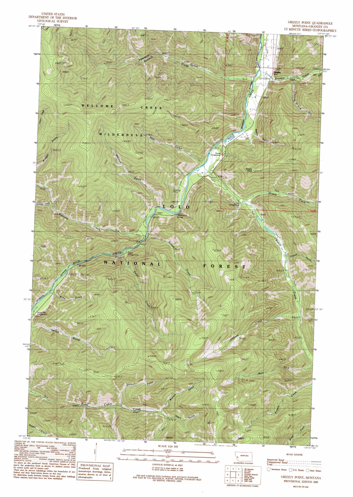
Grizzly Point Topo Map Montana
To zoom in, hover over the map of Grizzly Point
USGS Topo Quad 46113e6 - 1:24,000 scale
| Topo Map Name: | Grizzly Point |
| USGS Topo Quad ID: | 46113e6 |
| Print Size: | ca. 21 1/4" wide x 27" high |
| Southeast Coordinates: | 46.5° N latitude / 113.625° W longitude |
| Map Center Coordinates: | 46.5625° N latitude / 113.6875° W longitude |
| U.S. State: | MT |
| Filename: | o46113e6.jpg |
| Download Map JPG Image: | Grizzly Point topo map 1:24,000 scale |
| Map Type: | Topographic |
| Topo Series: | 7.5´ |
| Map Scale: | 1:24,000 |
| Source of Map Images: | United States Geological Survey (USGS) |
| Alternate Map Versions: |
Grizzly Point MT 1989, updated 1989 Download PDF Buy paper map Grizzly Point MT 1999, updated 2003 Download PDF Buy paper map Grizzly Point MT 2011 Download PDF Buy paper map Grizzly Point MT 2014 Download PDF Buy paper map |
| FStopo: | US Forest Service topo Grizzly Point is available: Download FStopo PDF Download FStopo TIF |
1:24,000 Topo Quads surrounding Grizzly Point
Southeast Missoula |
Bonner |
Clinton |
Mineral Ridge |
Union Peak |
Davis Point |
Elk Mountain |
Iris Point |
Ravenna |
Medicine Tree Hill |
Grayhorse Creek |
Cleveland Mountain |
Grizzly Point |
Spink Point |
Harvey Point |
Corley Gulch |
Sawmill Saddle |
Quigg Peak |
Alder Gulch |
Black Pine Ridge |
Willow Mountain |
Burnt Fork Lake |
Stony Creek |
Cornish Gulch |
Antelope Creek |
> Back to 46113e1 at 1:100,000 scale
> Back to 46112a1 at 1:250,000 scale
> Back to U.S. Topo Maps home
Grizzly Point topo map: Gazetteer
Grizzly Point: Gaps
Welcome Sawmill Saddle elevation 2189m 7181′Grizzly Point: Populated Places
Quigley elevation 1174m 3851′Grizzly Point: Post Offices
Quigley Post Office (historical) elevation 1174m 3851′Grizzly Point: Ridges
Grizzly Point elevation 1675m 5495′Grizzly Point: Springs
Gunbarrel Spring elevation 1209m 3966′Grizzly Point: Streams
Bobcat Creek elevation 1214m 3982′Brewster Creek elevation 1175m 3854′
Cinnabar Creek elevation 1379m 4524′
Dalles Creek elevation 1222m 4009′
Elkhorn Creek elevation 1361m 4465′
Fourth of July Creek elevation 1198m 3930′
Grizzly Creek elevation 1242m 4074′
Ranch Creek elevation 1196m 3923′
Sawmill Creek elevation 1169m 3835′
Welcome Creek elevation 1212m 3976′
West Fork Ranch Creek elevation 1403m 4603′
Grizzly Point: Trails
Butte Cabin Ridge Trail elevation 2391m 7844′Grizzly Point: Valleys
Ammon Gulch elevation 1646m 5400′Bear Gulch elevation 1209m 3966′
Colusa Gulch elevation 1309m 4294′
Gratton Gulch elevation 1234m 4048′
Hamm Gulch elevation 1174m 3851′
Oasis Gulch elevation 1839m 6033′
Sawmill Gulch elevation 1182m 3877′
Waho Gulch elevation 1254m 4114′
Wapato Gulch elevation 1787m 5862′
Grizzly Point digital topo map on disk
Buy this Grizzly Point topo map showing relief, roads, GPS coordinates and other geographical features, as a high-resolution digital map file on DVD: