Southeast Missoula Topo Map Montana
To zoom in, hover over the map of Southeast Missoula
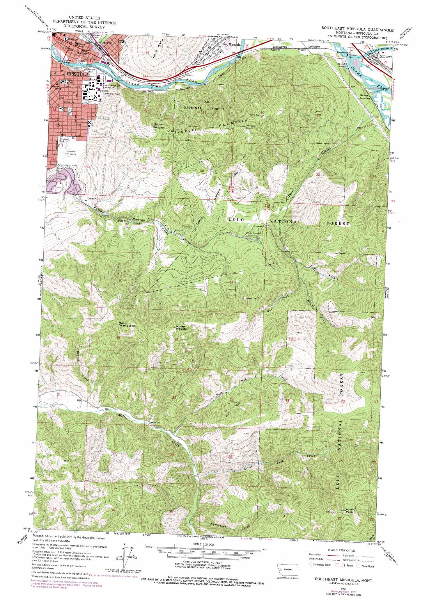
USGS Topo Quad 46113g8 - 1:24,000 scale
| Topo Map Name: | Southeast Missoula |
| USGS Topo Quad ID: | 46113g8 |
| Print Size: | ca. 21 1/4" wide x 27" high |
| Southeast Coordinates: | 46.75° N latitude / 113.875° W longitude |
| Map Center Coordinates: | 46.8125° N latitude / 113.9375° W longitude |
| U.S. State: | MT |
| Filename: | o46113g8.jpg |
| Download Map JPG Image: | Southeast Missoula topo map 1:24,000 scale |
| Map Type: | Topographic |
| Topo Series: | 7.5´ |
| Map Scale: | 1:24,000 |
| Source of Map Images: | United States Geological Survey (USGS) |
| Alternate Map Versions: |
Southeast Missoula MT 1964, updated 1967 Download PDF Buy paper map Southeast Missoula MT 1964, updated 1978 Download PDF Buy paper map Southeast Missoula MT 1964, updated 1978 Download PDF Buy paper map Southeast Missoula MT 1999, updated 2003 Download PDF Buy paper map Southeast Missoula MT 2011 Download PDF Buy paper map Southeast Missoula MT 2014 Download PDF Buy paper map |
| FStopo: | US Forest Service topo Southeast Missoula is available: Download FStopo PDF Download FStopo TIF |
1:24,000 Topo Quads surrounding Southeast Missoula
Frenchtown |
Evaro |
Stuart Peak |
Wapiti Lake |
Gold Creek Peak |
Primrose |
Northwest Missoula |
Northeast Missoula |
Blue Point |
Sunflower Mountain |
Blue Mountain |
Southwest Missoula |
Southeast Missoula |
Bonner |
Clinton |
Carlton Lake |
Florence |
Davis Point |
Elk Mountain |
Iris Point |
Saint Mary Peak |
Stevensville |
Grayhorse Creek |
Cleveland Mountain |
Grizzly Point |
> Back to 46113e1 at 1:100,000 scale
> Back to 46112a1 at 1:250,000 scale
> Back to U.S. Topo Maps home
Southeast Missoula topo map: Gazetteer
Southeast Missoula: Airports
Community Medical Center Heliport elevation 977m 3205′Southeast Missoula: Bridges
Blackfoot River Bridge elevation 993m 3257′Clark Fork River Bridge elevation 975m 3198′
Higgins Bridge elevation 973m 3192′
Rattlesnake Creek Bridge elevation 976m 3202′
Rattlesnake Creek Bridge elevation 986m 3234′
Southeast Missoula: Crossings
Interchange 105 elevation 981m 3218′Interchange 107 elevation 990m 3248′
Southeast Missoula: Dams
Milltown Dam elevation 989m 3244′Southeast Missoula: Lakes
Tunnel Lake elevation 995m 3264′Southeast Missoula: Mines
Mount Sentinel Mine elevation 1379m 4524′Southeast Missoula: Parks
Anderson Park elevation 977m 3205′Bess Reed Park elevation 974m 3195′
Bonner Park elevation 979m 3211′
Burlington Northern Plaza elevation 984m 3228′
Campbell Park elevation 976m 3202′
Caras Park elevation 974m 3195′
Clover Bowl elevation 979m 3211′
Dornblaser Track elevation 1011m 3316′
Gregory Park elevation 985m 3231′
Grizzly Statue elevation 982m 3221′
Hell Gate and Missoula Historical Marker elevation 999m 3277′
Jacobs Island Park elevation 974m 3195′
K Williams Natural Trail Area elevation 977m 3205′
Kiwanis Park elevation 976m 3202′
Madison Park elevation 977m 3205′
Mullan Statue elevation 984m 3228′
Pattee Canyon Picnic Area elevation 1259m 4130′
Rankin Park elevation 977m 3205′
River Bowl elevation 978m 3208′
Toole Park elevation 976m 3202′
University of Montana Soccer Field elevation 978m 3208′
Washington-Grizzly Stadium elevation 978m 3208′
Southeast Missoula: Populated Places
Bonner Junction elevation 997m 3270′East Missoula elevation 995m 3264′
Milltown elevation 1002m 3287′
Missoula elevation 978m 3208′
Mount Jumbo Trailer Court elevation 998m 3274′
Southeast Missoula: Post Offices
Milltown Post Office elevation 1002m 3287′Southeast Missoula: Reservoirs
Milltown Reservoir elevation 989m 3244′Southeast Missoula: Streams
Bear Run Creek elevation 1152m 3779′Blackfoot River elevation 991m 3251′
Dagret Creek elevation 1126m 3694′
Deer Creek elevation 996m 3267′
East Fork Deer Creek elevation 1289m 4229′
Limestone Creek elevation 1196m 3923′
Little Park Creek elevation 1176m 3858′
Middle Fork Deer Creek elevation 1313m 4307′
Rattlesnake Creek elevation 976m 3202′
West Fork Deer Creek elevation 1313m 4307′
Southeast Missoula: Summits
Ginny Mountain elevation 1431m 4694′Miller Peak elevation 2142m 7027′
Mitten Mountain elevation 1831m 6007′
Mount Dean Stone elevation 1891m 6204′
Mount Sentinel elevation 1564m 5131′
University Mountain elevation 1739m 5705′
Southeast Missoula: Valleys
Crazy Canyon elevation 1134m 3720′Hellgate Canyon elevation 972m 3188′
Pattee Canyon elevation 994m 3261′
Pattee Canyon elevation 1265m 4150′
Southeast Missoula: Wells
13N19W21AD__01 Well elevation 973m 3192′13N19W21AD__02 Well elevation 973m 3192′
13N19W22BC__01 Well elevation 979m 3211′
13N19W22BC__02 Well elevation 979m 3211′
13N19W22BC__03 Well elevation 979m 3211′
13N19W22CB__01 Well elevation 975m 3198′
13N19W22CB__02 Well elevation 975m 3198′
13N19W22DB__01 Well elevation 979m 3211′
13N19W22DB__02 Well elevation 979m 3211′
13N19W24CD__01 Well elevation 982m 3221′
13N19W27ACBC01 Well elevation 982m 3221′
13N19W27BC__01 Well elevation 978m 3208′
13N19W27CCAD01 Well elevation 978m 3208′
13N19W33AD__01 Well elevation 977m 3205′
13N19W34BB__01 Well elevation 979m 3211′
Southeast Missoula digital topo map on disk
Buy this Southeast Missoula topo map showing relief, roads, GPS coordinates and other geographical features, as a high-resolution digital map file on DVD: