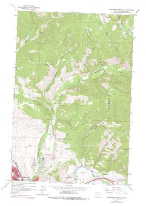
Northeast Missoula Topo Map Montana
To zoom in, hover over the map of Northeast Missoula
USGS Topo Quad 46113h8 - 1:24,000 scale
| Topo Map Name: | Northeast Missoula |
| USGS Topo Quad ID: | 46113h8 |
| Print Size: | ca. 21 1/4" wide x 27" high |
| Southeast Coordinates: | 46.875° N latitude / 113.875° W longitude |
| Map Center Coordinates: | 46.9375° N latitude / 113.9375° W longitude |
| U.S. State: | MT |
| Filename: | o46113h8.jpg |
| Download Map JPG Image: | Northeast Missoula topo map 1:24,000 scale |
| Map Type: | Topographic |
| Topo Series: | 7.5´ |
| Map Scale: | 1:24,000 |
| Source of Map Images: | United States Geological Survey (USGS) |
| Alternate Map Versions: |
Northeast Missoula MT 1964, updated 1967 Download PDF Buy paper map Northeast Missoula MT 1964, updated 1978 Download PDF Buy paper map Northeast Missoula MT 1999, updated 2003 Download PDF Buy paper map Northeast Missoula MT 2011 Download PDF Buy paper map Northeast Missoula MT 2014 Download PDF Buy paper map |
| FStopo: | US Forest Service topo Northeast Missoula is available: Download FStopo PDF Download FStopo TIF |
1:24,000 Topo Quads surrounding Northeast Missoula
> Back to 46113e1 at 1:100,000 scale
> Back to 46112a1 at 1:250,000 scale
> Back to U.S. Topo Maps home
Northeast Missoula topo map: Gazetteer
Northeast Missoula: Bridges
Bandmann Bridge elevation 985m 3231′Orange Street Underpass elevation 977m 3205′
Northeast Missoula: Canals
Quast Ditch elevation 1084m 3556′Williams Ditch elevation 1074m 3523′
Northeast Missoula: Crossings
Interchange 104 elevation 983m 3225′Interchange 110 elevation 1001m 3284′
Northeast Missoula: Dams
Peterson Lake Dam elevation 2074m 6804′Northeast Missoula: Flats
Bandmann Flats elevation 995m 3264′Northeast Missoula: Parks
Greenough Park elevation 989m 3244′Junction of the Hell Gate and Big Blackfoot Rivers Historical Marker elevation 1000m 3280′
Northside Park elevation 975m 3198′
Pineview Park elevation 1019m 3343′
Rattlesnake National Recreation Area elevation 2203m 7227′
Rattlesnake National Recreation Site elevation 1285m 4215′
Northeast Missoula: Populated Places
Big Pines Mobile Court elevation 998m 3274′Carols Court elevation 1003m 3290′
Circle 'J' Mobile Park elevation 999m 3277′
Greenland Park Trailer Court elevation 1005m 3297′
Harveys Mobile Home Court elevation 1005m 3297′
Mountain View Court elevation 1004m 3293′
Pinegrove elevation 996m 3267′
Pinegrove Trailer Park elevation 1001m 3284′
West Riverside elevation 1001m 3284′
Northeast Missoula: Streams
East Fork Grant Creek elevation 1224m 4015′Fraser Creek elevation 1166m 3825′
Marshall Creek elevation 986m 3234′
Pilcher Creek elevation 1183m 3881′
Northeast Missoula: Summits
Mount Jumbo elevation 1452m 4763′Waterworks Hill elevation 1037m 3402′
Woody Mountain elevation 1890m 6200′
Northeast Missoula: Valleys
Danny O'Brien Gulch elevation 1087m 3566′Marshall Canyon elevation 990m 3248′
Mittower Gulch elevation 996m 3267′
Sawmill Gulch elevation 1091m 3579′
Spring Gulch elevation 1104m 3622′
Woods Gulch elevation 1113m 3651′
Northeast Missoula: Wells
13N19W10DC__01 Well elevation 1111m 3645′13N19W11BA__01 Well elevation 1055m 3461′
13N19W11DB__01 Well elevation 1045m 3428′
13N19W11DC__01 Well elevation 1037m 3402′
13N19W12BB__01 Well elevation 1125m 3690′
13N19W12BB__02 Well elevation 1125m 3690′
13N19W12BBBB01 Well elevation 1110m 3641′
13N19W13AD__01 Well elevation 995m 3264′
13N19W13AD__02 Well elevation 995m 3264′
13N19W14BAAA01 Well elevation 1031m 3382′
13N19W14DB__01 Well elevation 1093m 3585′
13N19W15DA__01 Well elevation 1054m 3458′
13N19W24ABCA01 Well elevation 997m 3270′
14N19W15BABD01 Well elevation 1222m 4009′
14N19W35DD__01 Well elevation 1097m 3599′
14N19W36BBCC01 Well elevation 1119m 3671′
Northeast Missoula digital topo map on disk
Buy this Northeast Missoula topo map showing relief, roads, GPS coordinates and other geographical features, as a high-resolution digital map file on DVD:


