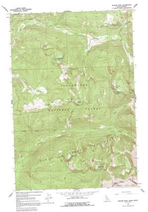
Ranger Peak Topo Map Idaho
To zoom in, hover over the map of Ranger Peak
USGS Topo Quad 46114e4 - 1:24,000 scale
| Topo Map Name: | Ranger Peak |
| USGS Topo Quad ID: | 46114e4 |
| Print Size: | ca. 21 1/4" wide x 27" high |
| Southeast Coordinates: | 46.5° N latitude / 114.375° W longitude |
| Map Center Coordinates: | 46.5625° N latitude / 114.4375° W longitude |
| U.S. States: | ID, MT |
| Filename: | o46114e4.jpg |
| Download Map JPG Image: | Ranger Peak topo map 1:24,000 scale |
| Map Type: | Topographic |
| Topo Series: | 7.5´ |
| Map Scale: | 1:24,000 |
| Source of Map Images: | United States Geological Survey (USGS) |
| Alternate Map Versions: |
Ranger Peak ID 1964, updated 1968 Download PDF Buy paper map Ranger Peak ID 1964, updated 1992 Download PDF Buy paper map Ranger Peak ID 1994, updated 1997 Download PDF Buy paper map Ranger Peak ID 2011 Download PDF Buy paper map Ranger Peak ID 2013 Download PDF Buy paper map |
| FStopo: | US Forest Service topo Ranger Peak is available: Download FStopo PDF Download FStopo TIF |
1:24,000 Topo Quads surrounding Ranger Peak
> Back to 46114e1 at 1:100,000 scale
> Back to 46114a1 at 1:250,000 scale
> Back to U.S. Topo Maps home
Ranger Peak topo map: Gazetteer
Ranger Peak: Flats
Beaver Meadows elevation 2076m 6811′Ranger Peak: Lakes
Beaver Lake elevation 2041m 6696′Ranger Lake elevation 1993m 6538′
Rudd-Moore Lakes elevation 1938m 6358′
Siah Lake elevation 1958m 6423′
Spruce Creek Lakes elevation 2104m 6902′
Ranger Peak: Streams
North Fork Spruce Creek elevation 1599m 5246′North Fork Storm Creek elevation 1525m 5003′
Shoot Creek elevation 1583m 5193′
South Fork Spruce Creek elevation 1599m 5246′
South Fork Storm Creek elevation 1525m 5003′
Spruce Creek elevation 1482m 4862′
Ranger Peak: Summits
Old Stormy elevation 2490m 8169′Old Stormy elevation 2490m 8169′
Ranger Peak elevation 2686m 8812′
Ranger Peak elevation 2689m 8822′
Ranger Peak digital topo map on disk
Buy this Ranger Peak topo map showing relief, roads, GPS coordinates and other geographical features, as a high-resolution digital map file on DVD:


