Lupine Creek Topo Map Montana
To zoom in, hover over the map of Lupine Creek
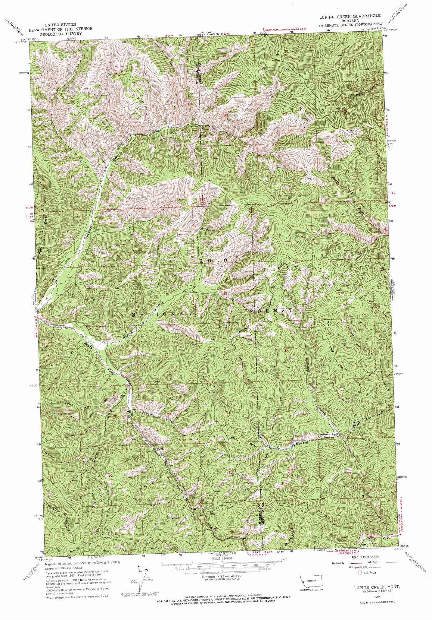
USGS Topo Quad 46114g5 - 1:24,000 scale
| Topo Map Name: | Lupine Creek |
| USGS Topo Quad ID: | 46114g5 |
| Print Size: | ca. 21 1/4" wide x 27" high |
| Southeast Coordinates: | 46.75° N latitude / 114.5° W longitude |
| Map Center Coordinates: | 46.8125° N latitude / 114.5625° W longitude |
| U.S. State: | MT |
| Filename: | o46114g5.jpg |
| Download Map JPG Image: | Lupine Creek topo map 1:24,000 scale |
| Map Type: | Topographic |
| Topo Series: | 7.5´ |
| Map Scale: | 1:24,000 |
| Source of Map Images: | United States Geological Survey (USGS) |
| Alternate Map Versions: |
Lupine Creek MT 1964, updated 1967 Download PDF Buy paper map Lupine Creek MT 1999, updated 2003 Download PDF Buy paper map Lupine Creek MT 2011 Download PDF Buy paper map Lupine Creek MT 2014 Download PDF Buy paper map |
| FStopo: | US Forest Service topo Lupine Creek is available: Download FStopo PDF Download FStopo TIF |
1:24,000 Topo Quads surrounding Lupine Creek
Lozeau |
Tarkio |
Stark South |
Alberton |
Huson |
Saint Patrick Peak |
Williams Peak |
Deer Peak |
Petty Mountain |
Diamond Point |
Schley Mountain |
White Mountain |
Lupine Creek |
Garden Point |
Camp Creek |
Rhodes Peak |
Granite Pass |
Lolo Hot Springs |
West Fork Butte |
Dick Creek |
Cayuse Junction |
Rocky Point |
Roundtop |
Ranger Peak |
Saint Joseph Peak |
> Back to 46114e1 at 1:100,000 scale
> Back to 46114a1 at 1:250,000 scale
> Back to U.S. Topo Maps home
Lupine Creek topo map: Gazetteer
Lupine Creek: Flats
Howard Creek Meadows elevation 1335m 4379′Lupine Creek: Springs
11N23W07ABDB01 Spring elevation 1554m 5098′Lupine Creek: Streams
Lupine Creek elevation 1171m 3841′Martin Creek elevation 1232m 4041′
Oriole Creek elevation 1212m 3976′
Sullivan Creek elevation 1231m 4038′
Tepee Creek elevation 1329m 4360′
Lupine Creek: Trails
Oriole Creek Trail elevation 1653m 5423′Tepee Ridge Trail elevation 1563m 5127′
Lupine Creek digital topo map on disk
Buy this Lupine Creek topo map showing relief, roads, GPS coordinates and other geographical features, as a high-resolution digital map file on DVD: