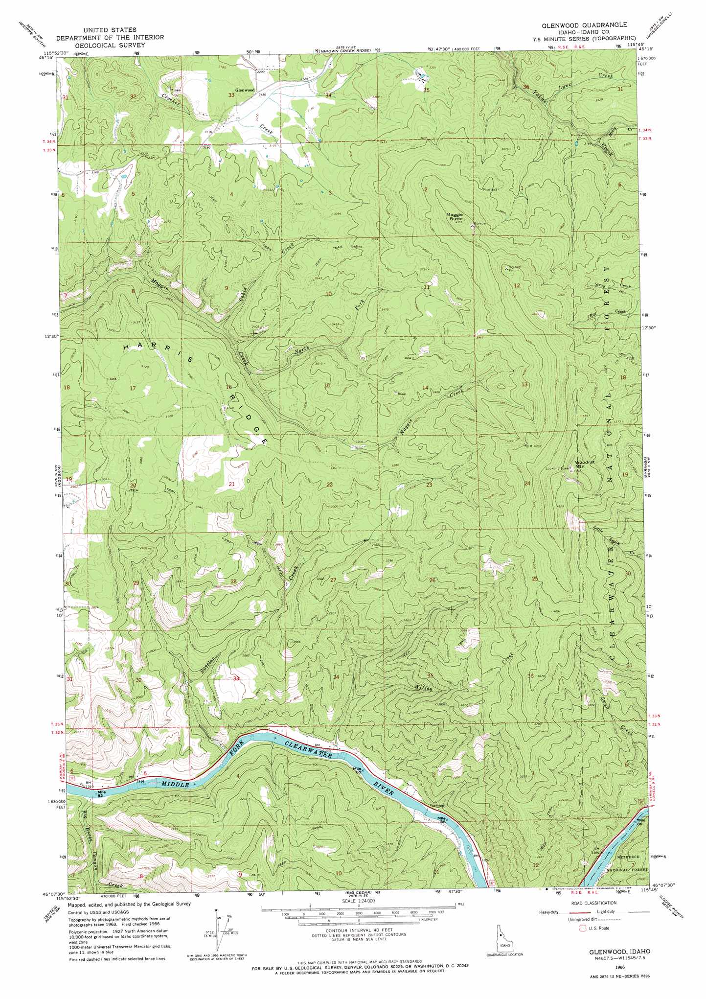
Glenwood Topo Map Idaho
To zoom in, hover over the map of Glenwood
USGS Topo Quad 46115b7 - 1:24,000 scale
| Topo Map Name: | Glenwood |
| USGS Topo Quad ID: | 46115b7 |
| Print Size: | ca. 21 1/4" wide x 27" high |
| Southeast Coordinates: | 46.125° N latitude / 115.75° W longitude |
| Map Center Coordinates: | 46.1875° N latitude / 115.8125° W longitude |
| U.S. State: | ID |
| Filename: | o46115b7.jpg |
| Download Map JPG Image: | Glenwood topo map 1:24,000 scale |
| Map Type: | Topographic |
| Topo Series: | 7.5´ |
| Map Scale: | 1:24,000 |
| Source of Map Images: | United States Geological Survey (USGS) |
| Alternate Map Versions: |
Glenwood ID 1966, updated 1968 Download PDF Buy paper map Glenwood ID 1994, updated 1997 Download PDF Buy paper map Glenwood ID 2011 Download PDF Buy paper map Glenwood ID 2014 Download PDF Buy paper map |
| FStopo: | US Forest Service topo Glenwood is available: Download FStopo PDF Download FStopo TIF |
1:24,000 Topo Quads surrounding Glenwood
Rudo |
Weippe North |
Pierce |
Hemlock Butte |
Snowy Summit |
Woodland |
Weippe South |
Brown Creek Ridge |
Musselshell |
Boundary Peak |
Kamiah |
Kooskia |
Glenwood |
Syringa |
Lowell |
Nezperce Se |
Stites |
Big Cedar |
Lodge Point |
Goddard Point |
Grangeville East |
Harpster |
Corral Hill |
Pilot Knob |
Iron Mountain |
> Back to 46115a1 at 1:100,000 scale
> Back to 46114a1 at 1:250,000 scale
> Back to U.S. Topo Maps home
Glenwood topo map: Gazetteer
Glenwood: Populated Places
Glenwood elevation 955m 3133′Glenwood: Streams
Big Horse Canyon Creek elevation 401m 1315′Cabin Creek elevation 822m 2696′
Lynx Creek elevation 939m 3080′
Molly Creek elevation 974m 3195′
North Fork Maggie Creek elevation 853m 2798′
Snyder Creek elevation 915m 3001′
Suttler Creek elevation 732m 2401′
Wilson Creek elevation 406m 1332′
Glenwood: Summits
Maggie Butte elevation 1321m 4333′Woodrat Mountain elevation 1516m 4973′
Glenwood digital topo map on disk
Buy this Glenwood topo map showing relief, roads, GPS coordinates and other geographical features, as a high-resolution digital map file on DVD: