Boundary Peak Topo Map Idaho
To zoom in, hover over the map of Boundary Peak
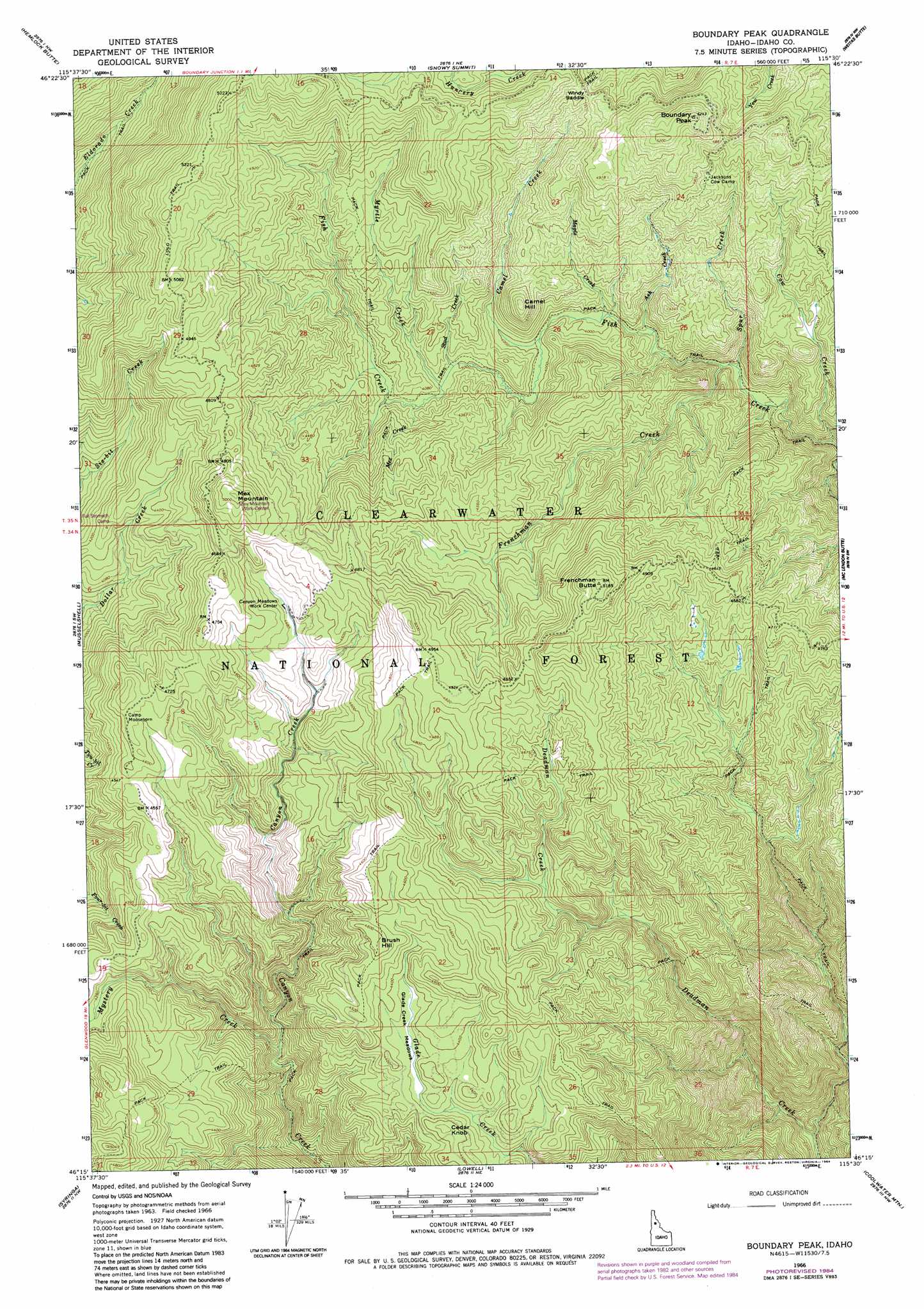
USGS Topo Quad 46115c5 - 1:24,000 scale
| Topo Map Name: | Boundary Peak |
| USGS Topo Quad ID: | 46115c5 |
| Print Size: | ca. 21 1/4" wide x 27" high |
| Southeast Coordinates: | 46.25° N latitude / 115.5° W longitude |
| Map Center Coordinates: | 46.3125° N latitude / 115.5625° W longitude |
| U.S. State: | ID |
| Filename: | o46115c5.jpg |
| Download Map JPG Image: | Boundary Peak topo map 1:24,000 scale |
| Map Type: | Topographic |
| Topo Series: | 7.5´ |
| Map Scale: | 1:24,000 |
| Source of Map Images: | United States Geological Survey (USGS) |
| Alternate Map Versions: |
Boundary Peak ID 1966, updated 1968 Download PDF Buy paper map Boundary Peak ID 1966, updated 1984 Download PDF Buy paper map Boundary Peak ID 1994, updated 1997 Download PDF Buy paper map Boundary Peak ID 1994, updated 1997 Download PDF Buy paper map Boundary Peak ID 2011 Download PDF Buy paper map Boundary Peak ID 2014 Download PDF Buy paper map |
| FStopo: | US Forest Service topo Boundary Peak is available: Download FStopo PDF Download FStopo TIF |
1:24,000 Topo Quads surrounding Boundary Peak
Jaype |
French Mountain |
Larch Butte |
Lean-To Point |
Cook Mountain |
Pierce |
Hemlock Butte |
Snowy Summit |
Weitas Butte |
Liz Butte |
Brown Creek Ridge |
Musselshell |
Boundary Peak |
Mclendon Butte |
Huckleberry Butte |
Glenwood |
Syringa |
Lowell |
Coolwater Mountain |
Chimney Peak |
Big Cedar |
Lodge Point |
Goddard Point |
Stillman Point |
Selway Falls |
> Back to 46115a1 at 1:100,000 scale
> Back to 46114a1 at 1:250,000 scale
> Back to U.S. Topo Maps home
Boundary Peak topo map: Gazetteer
Boundary Peak: Flats
Fish Creek Meadows elevation 1253m 4110′Boundary Peak: Gaps
Windy Saddle elevation 1441m 4727′Boundary Peak: Streams
Ant Creek elevation 1058m 3471′Ash Creek elevation 1184m 3884′
Camel Creek elevation 1224m 4015′
Cow Creek elevation 1081m 3546′
Frenchman Creek elevation 1148m 3766′
Maple Creek elevation 1201m 3940′
Mex Creek elevation 1232m 4041′
Myrtle Creek elevation 1232m 4041′
Mystery Creek elevation 1114m 3654′
Spur Creek elevation 1133m 3717′
Stud Creek elevation 1232m 4041′
Boundary Peak: Summits
Boundary Peak elevation 1599m 5246′Brush Hill elevation 1411m 4629′
Camel Hill elevation 1391m 4563′
Cedar Knob elevation 1358m 4455′
Frenchman Butte elevation 1577m 5173′
Mex Mountain elevation 1535m 5036′
Boundary Peak digital topo map on disk
Buy this Boundary Peak topo map showing relief, roads, GPS coordinates and other geographical features, as a high-resolution digital map file on DVD: