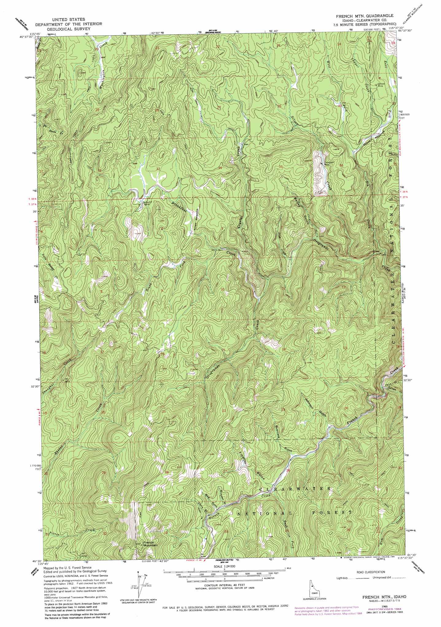
French Mountain Topo Map Idaho
To zoom in, hover over the map of French Mountain
USGS Topo Quad 46115e6 - 1:24,000 scale
| Topo Map Name: | French Mountain |
| USGS Topo Quad ID: | 46115e6 |
| Print Size: | ca. 21 1/4" wide x 27" high |
| Southeast Coordinates: | 46.5° N latitude / 115.625° W longitude |
| Map Center Coordinates: | 46.5625° N latitude / 115.6875° W longitude |
| U.S. State: | ID |
| Filename: | o46115e6.jpg |
| Download Map JPG Image: | French Mountain topo map 1:24,000 scale |
| Map Type: | Topographic |
| Topo Series: | 7.5´ |
| Map Scale: | 1:24,000 |
| Source of Map Images: | United States Geological Survey (USGS) |
| Alternate Map Versions: |
French Mountain ID 1965, updated 1967 Download PDF Buy paper map French Mountain ID 1965, updated 1984 Download PDF Buy paper map French Mountain ID 1994, updated 1997 Download PDF Buy paper map French Mountain ID 2011 Download PDF Buy paper map French Mountain ID 2014 Download PDF Buy paper map |
| FStopo: | US Forest Service topo French Mountain is available: Download FStopo PDF Download FStopo TIF |
1:24,000 Topo Quads surrounding French Mountain
Township Butte |
Bertha Hill |
Thompson Point |
Sheep Mountain |
The Nub |
John Lewis Mountain |
Headquarters |
Browns Rock |
Clarke Mountain |
Pot Mountain |
Whiskey Butte |
Jaype |
French Mountain |
Larch Butte |
Lean-To Point |
Weippe North |
Pierce |
Hemlock Butte |
Snowy Summit |
Weitas Butte |
Weippe South |
Brown Creek Ridge |
Musselshell |
Boundary Peak |
Mclendon Butte |
> Back to 46115e1 at 1:100,000 scale
> Back to 46114a1 at 1:250,000 scale
> Back to U.S. Topo Maps home
French Mountain topo map: Gazetteer
French Mountain: Flats
Arnett Meadows elevation 1203m 3946′Oxford Meadows elevation 1145m 3756′
French Mountain: Mines
Campbell Mine elevation 1142m 3746′Oxford Mine elevation 1193m 3914′
French Mountain: Streams
Breakfast Creek elevation 1092m 3582′Copper Creek elevation 1151m 3776′
Crystal Creek elevation 1083m 3553′
East Fork Elk Creek elevation 1135m 3723′
East Fork French Creek elevation 1219m 3999′
Elk Creek elevation 1024m 3359′
Irish Creek elevation 1074m 3523′
Silver Creek elevation 1047m 3435′
South Fork Breakfast Creek elevation 1164m 3818′
Sylvan Creek elevation 1077m 3533′
West Fork Elk Creek elevation 1135m 3723′
French Mountain: Summits
French Mountain elevation 1627m 5337′French Mountain: Valleys
Bailey Gulch elevation 1066m 3497′Blue Gulch elevation 1306m 4284′
Bluebell Gulch elevation 1297m 4255′
Business Gulch elevation 1206m 3956′
China Gulch elevation 1319m 4327′
Fidelity Gulch elevation 1224m 4015′
Johnson Gulch elevation 1187m 3894′
French Mountain digital topo map on disk
Buy this French Mountain topo map showing relief, roads, GPS coordinates and other geographical features, as a high-resolution digital map file on DVD: