Hoodoo Pass Topo Map Idaho
To zoom in, hover over the map of Hoodoo Pass
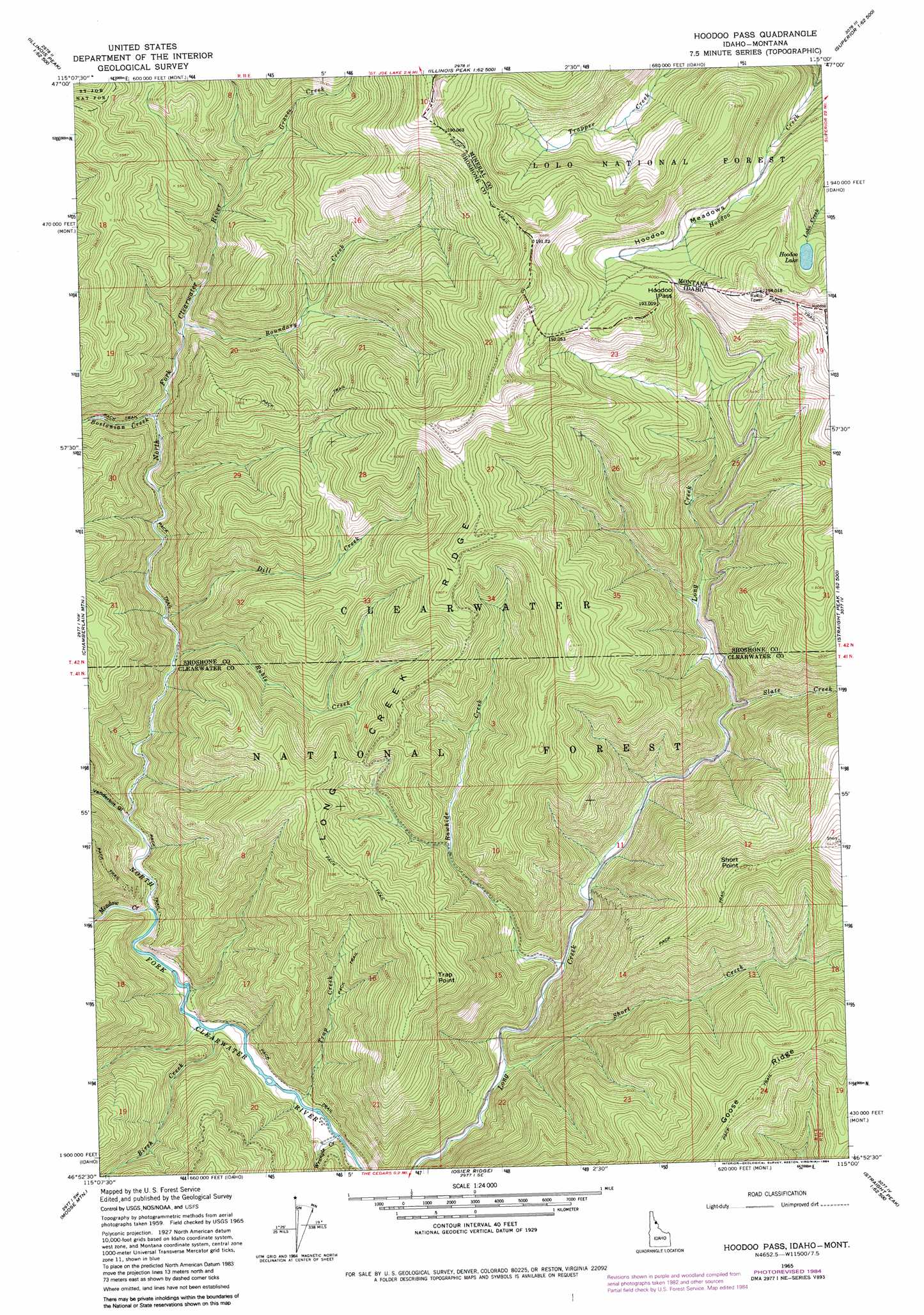
USGS Topo Quad 46115h1 - 1:24,000 scale
| Topo Map Name: | Hoodoo Pass |
| USGS Topo Quad ID: | 46115h1 |
| Print Size: | ca. 21 1/4" wide x 27" high |
| Southeast Coordinates: | 46.875° N latitude / 115° W longitude |
| Map Center Coordinates: | 46.9375° N latitude / 115.0625° W longitude |
| U.S. States: | ID, MT |
| Filename: | o46115h1.jpg |
| Download Map JPG Image: | Hoodoo Pass topo map 1:24,000 scale |
| Map Type: | Topographic |
| Topo Series: | 7.5´ |
| Map Scale: | 1:24,000 |
| Source of Map Images: | United States Geological Survey (USGS) |
| Alternate Map Versions: |
Hoodoo Pass ID 1965, updated 1967 Download PDF Buy paper map Hoodoo Pass ID 1965, updated 1984 Download PDF Buy paper map Hoodoo Pass ID 1965, updated 1984 Download PDF Buy paper map Hoodoo Pass ID 1994, updated 1997 Download PDF Buy paper map Hoodoo Pass ID 2011 Download PDF Buy paper map Hoodoo Pass ID 2013 Download PDF Buy paper map |
| FStopo: | US Forest Service topo Hoodoo Pass is available: Download FStopo PDF Download FStopo TIF |
1:24,000 Topo Quads surrounding Hoodoo Pass
Berge Peak |
Torino Peak |
Wilson Gulch |
Superior |
Idaho Gulch |
Red Ives Peak |
Sherlock Peak |
Illinois Peak |
Landowner Mountain |
Lozeau |
Bacon Peak |
Chamberlain Mountain |
Hoodoo Pass |
Straight Peak |
Saint Patrick Peak |
Elizabeth Lake |
Moose Mountain |
Osier Ridge |
Bruin Hill |
Schley Mountain |
Junction Mountain |
Scurvy Mountain |
Gorman Hill |
Toboggan Ridge |
Rhodes Peak |
> Back to 46115e1 at 1:100,000 scale
> Back to 46114a1 at 1:250,000 scale
> Back to U.S. Topo Maps home
Hoodoo Pass topo map: Gazetteer
Hoodoo Pass: Flats
Hoodoo Meadows elevation 1760m 5774′Hoodoo Pass: Gaps
Hoodoo Pass elevation 1830m 6003′Hoodoo Pass elevation 1828m 5997′
Hoodoo Pass: Lakes
Hoodoo Lake elevation 1787m 5862′Hoodoo Pass: Ridges
Goose Ridge elevation 1877m 6158′Long Creek Ridge elevation 1660m 5446′
Hoodoo Pass: Streams
Birch Creek elevation 1149m 3769′Bostonian Creek elevation 1353m 4438′
Boundary Creek elevation 1416m 4645′
Dill Creek elevation 1256m 4120′
Graves Creek elevation 1532m 5026′
Meadow Creek elevation 1171m 3841′
Rawhide Creek elevation 1211m 3973′
Ruble Creek elevation 1244m 4081′
Short Creek elevation 1174m 3851′
Slate Creek elevation 1305m 4281′
Trap Creek elevation 1134m 3720′
Wrangle Creek elevation 1120m 3674′
Hoodoo Pass: Summits
Short Point elevation 1890m 6200′Trap Point elevation 1753m 5751′
Hoodoo Pass: Valleys
Vanderbilt Gulch elevation 1194m 3917′Hoodoo Pass digital topo map on disk
Buy this Hoodoo Pass topo map showing relief, roads, GPS coordinates and other geographical features, as a high-resolution digital map file on DVD: