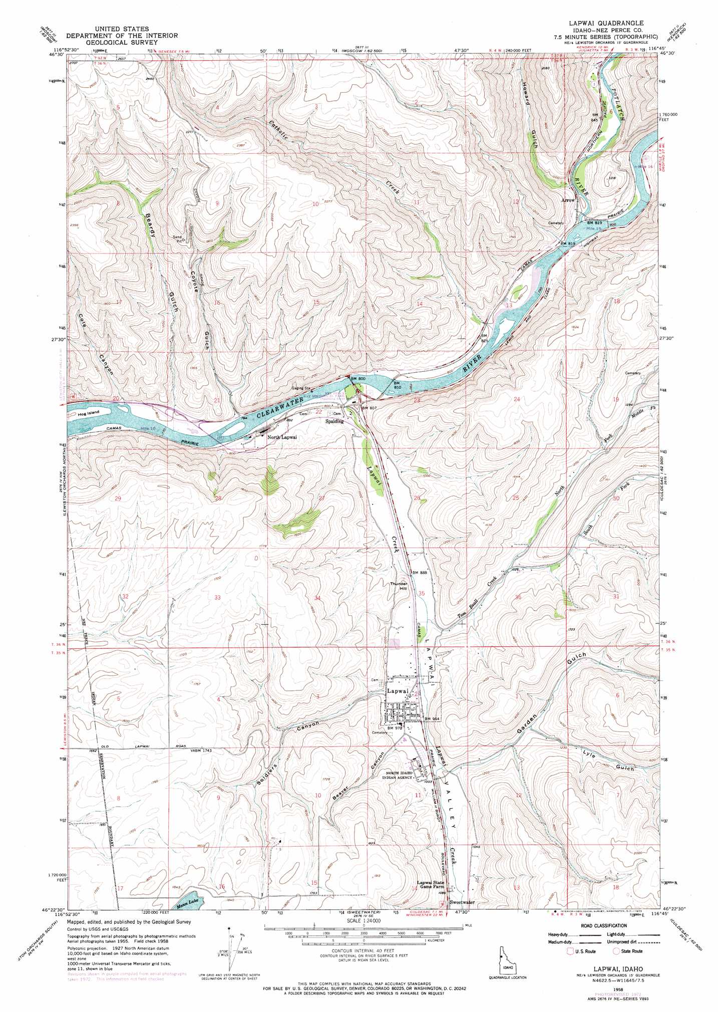
Lapwai Topo Map Idaho
To zoom in, hover over the map of Lapwai
USGS Topo Quad 46116d7 - 1:24,000 scale
| Topo Map Name: | Lapwai |
| USGS Topo Quad ID: | 46116d7 |
| Print Size: | ca. 21 1/4" wide x 27" high |
| Southeast Coordinates: | 46.375° N latitude / 116.75° W longitude |
| Map Center Coordinates: | 46.4375° N latitude / 116.8125° W longitude |
| U.S. State: | ID |
| Filename: | o46116d7.jpg |
| Download Map JPG Image: | Lapwai topo map 1:24,000 scale |
| Map Type: | Topographic |
| Topo Series: | 7.5´ |
| Map Scale: | 1:24,000 |
| Source of Map Images: | United States Geological Survey (USGS) |
| Alternate Map Versions: |
Lapwai ID 1958, updated 1959 Download PDF Buy paper map Lapwai ID 1958, updated 1973 Download PDF Buy paper map Lapwai ID 1958, updated 1973 Download PDF Buy paper map Lapwai ID 2010 Download PDF Buy paper map Lapwai ID 2013 Download PDF Buy paper map |
1:24,000 Topo Quads surrounding Lapwai
Moscow West |
Moscow East |
Troy |
Little Bear Ridge |
Texas Ridge |
Uniontown |
Genesee |
Green Knob |
Juliaetta |
Lenore |
Clarkston |
Lewiston Orchards North |
Lapwai |
Culdesac North |
Gifford |
Asotin |
Lewiston Orchards South |
Sweetwater |
Culdesac South |
Reubens |
Weissenfels Ridge |
Captain John Rapids |
Waha |
Winchester West |
Winchester East |
> Back to 46116a1 at 1:100,000 scale
> Back to 46116a1 at 1:250,000 scale
> Back to U.S. Topo Maps home
Lapwai topo map: Gazetteer
Lapwai: Arches
The Ant and the Yellowjacket elevation 247m 810′Lapwai: Islands
Hog Island elevation 245m 803′Lapwai: Parks
Lapwai State Game Farm elevation 327m 1072′Nez Perce National Historic Park - Spalding Area elevation 242m 793′
Nez Perce National Historical Park elevation 242m 793′
Lapwai: Populated Places
Arrow elevation 248m 813′Joseph elevation 246m 807′
Lapwai elevation 291m 954′
North Lapwai elevation 243m 797′
Spalding elevation 251m 823′
Lapwai: Streams
Catholic Creek elevation 241m 790′Lapwai Creek elevation 240m 787′
Middle Fork Tom Beall Creek elevation 378m 1240′
North Fork Tom Beall Creek elevation 305m 1000′
Potlatch River elevation 244m 800′
South Fork Tom Beall Creek elevation 305m 1000′
Tom Beall Creek elevation 279m 915′
Lapwai: Summits
Thunder Hill elevation 321m 1053′Lapwai: Valleys
Beardy Gulch elevation 255m 836′Beaver Canyon elevation 315m 1033′
Cole Canyon elevation 246m 807′
Coyote Gulch elevation 244m 800′
Garden Gulch elevation 315m 1033′
Howard Gulch elevation 253m 830′
Lapwai Valley elevation 242m 793′
Lyle Gulch elevation 354m 1161′
Soldiers Canyon elevation 293m 961′
Lapwai digital topo map on disk
Buy this Lapwai topo map showing relief, roads, GPS coordinates and other geographical features, as a high-resolution digital map file on DVD: