Ahsahka Topo Map Idaho
To zoom in, hover over the map of Ahsahka
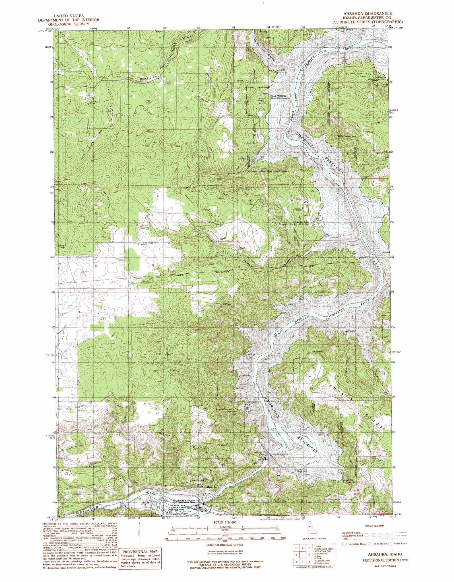
USGS Topo Quad 46116e3 - 1:24,000 scale
| Topo Map Name: | Ahsahka |
| USGS Topo Quad ID: | 46116e3 |
| Print Size: | ca. 21 1/4" wide x 27" high |
| Southeast Coordinates: | 46.5° N latitude / 116.25° W longitude |
| Map Center Coordinates: | 46.5625° N latitude / 116.3125° W longitude |
| U.S. State: | ID |
| Filename: | o46116e3.jpg |
| Download Map JPG Image: | Ahsahka topo map 1:24,000 scale |
| Map Type: | Topographic |
| Topo Series: | 7.5´ |
| Map Scale: | 1:24,000 |
| Source of Map Images: | United States Geological Survey (USGS) |
| Alternate Map Versions: |
Ahsahka ID 1990, updated 1991 Download PDF Buy paper map Ahsahka ID 1994, updated 1997 Download PDF Buy paper map Ahsahka ID 2011 Download PDF Buy paper map Ahsahka ID 2014 Download PDF Buy paper map |
| FStopo: | US Forest Service topo Ahsahka is available: Download FStopo PDF Download FStopo TIF |
1:24,000 Topo Quads surrounding Ahsahka
Deary |
Bovill |
Mcgary Butte |
Elk River |
Elk Butte |
Texas Ridge |
Park |
Alderman Ridge |
Elk Creek Falls |
Little Green Mountain |
Lenore |
Southwick |
Ahsahka |
Dent |
Grangemont |
Gifford |
Peck |
Orofino West |
Orofino East |
Rudo |
Reubens |
Fletcher |
Mohler |
Sixmile Creek |
Woodland |
> Back to 46116e1 at 1:100,000 scale
> Back to 46116a1 at 1:250,000 scale
> Back to U.S. Topo Maps home
Ahsahka topo map: Gazetteer
Ahsahka: Airports
Dworshak Heliport elevation 493m 1617′Ahsahka: Bays
Bruces Eddy elevation 489m 1604′Little Bay elevation 489m 1604′
Ahsahka: Dams
Dworshak Dam elevation 435m 1427′Ahsahka: Parks
Beaver Dam Recreation Area elevation 489m 1604′Dworshak State Park elevation 555m 1820′
Ahsahka: Populated Places
Ahsahka elevation 304m 997′Bruce Eddy elevation 489m 1604′
Ahsahka: Reservoirs
Dworshak Reservoir elevation 435m 1427′Ahsahka: Ridges
Eureka Ridge elevation 795m 2608′Ahsahka: Streams
Canyon Creek elevation 489m 1604′Dicks Creek elevation 489m 1604′
Elk Creek elevation 489m 1604′
Freeman Creek elevation 489m 1604′
Indian Creek elevation 489m 1604′
Ahsahka digital topo map on disk
Buy this Ahsahka topo map showing relief, roads, GPS coordinates and other geographical features, as a high-resolution digital map file on DVD: