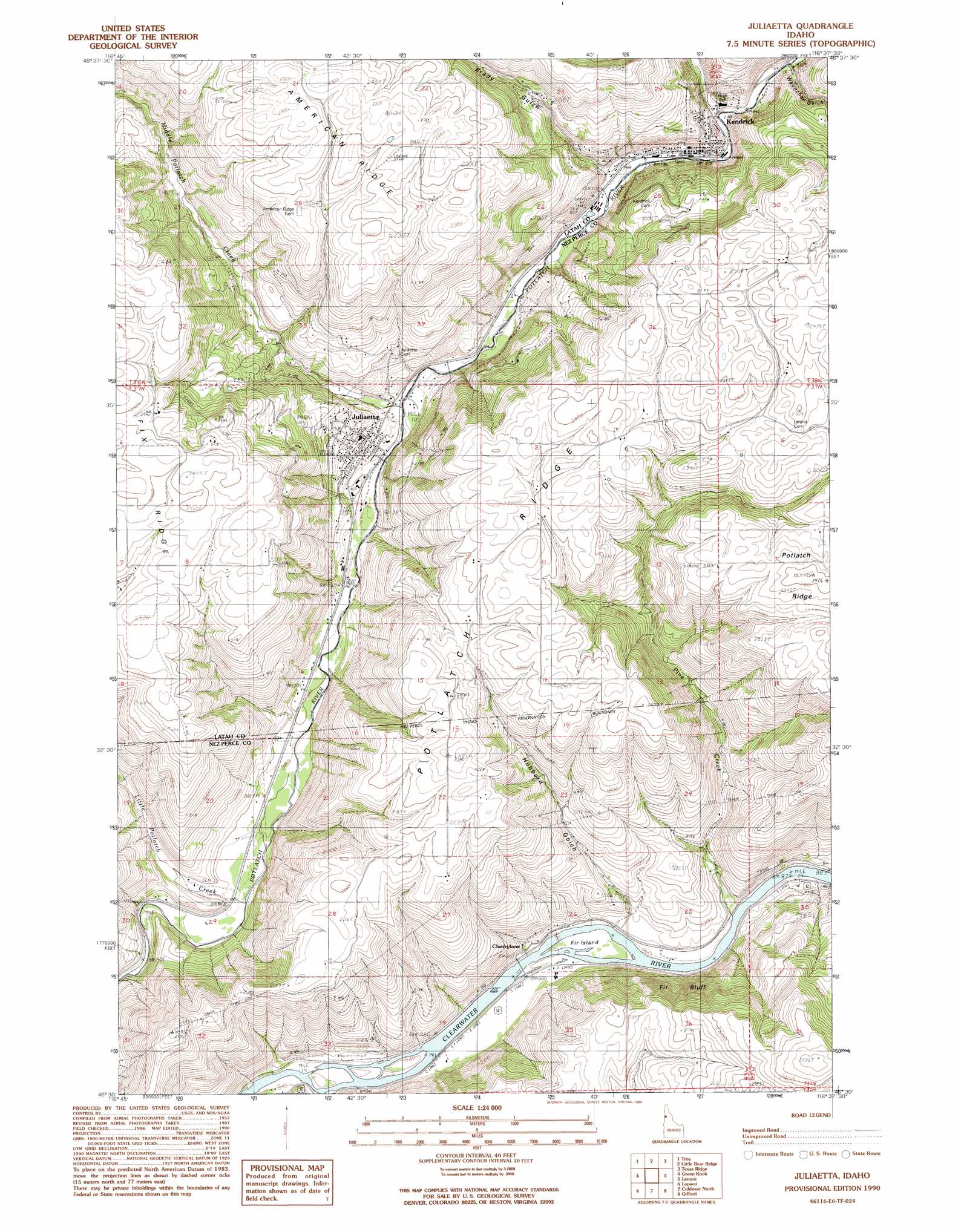
Juliaetta Topo Map Idaho
To zoom in, hover over the map of Juliaetta
USGS Topo Quad 46116e6 - 1:24,000 scale
| Topo Map Name: | Juliaetta |
| USGS Topo Quad ID: | 46116e6 |
| Print Size: | ca. 21 1/4" wide x 27" high |
| Southeast Coordinates: | 46.5° N latitude / 116.625° W longitude |
| Map Center Coordinates: | 46.5625° N latitude / 116.6875° W longitude |
| U.S. State: | ID |
| Filename: | o46116e6.jpg |
| Download Map JPG Image: | Juliaetta topo map 1:24,000 scale |
| Map Type: | Topographic |
| Topo Series: | 7.5´ |
| Map Scale: | 1:24,000 |
| Source of Map Images: | United States Geological Survey (USGS) |
| Alternate Map Versions: |
Juliaetta ID 1990, updated 1990 Download PDF Buy paper map Juliaetta ID 2010 Download PDF Buy paper map Juliaetta ID 2013 Download PDF Buy paper map |
1:24,000 Topo Quads surrounding Juliaetta
Robinson Lake |
Moscow Mountain |
Stanford |
Deary |
Bovill |
Moscow East |
Troy |
Little Bear Ridge |
Texas Ridge |
Park |
Genesee |
Green Knob |
Juliaetta |
Lenore |
Southwick |
Lewiston Orchards North |
Lapwai |
Culdesac North |
Gifford |
Peck |
Lewiston Orchards South |
Sweetwater |
Culdesac South |
Reubens |
Fletcher |
> Back to 46116e1 at 1:100,000 scale
> Back to 46116a1 at 1:250,000 scale
> Back to U.S. Topo Maps home
Juliaetta topo map: Gazetteer
Juliaetta: Cliffs
Fir Bluff elevation 436m 1430′Juliaetta: Islands
Fir Island elevation 263m 862′Juliaetta: Populated Places
Cherrylane elevation 262m 859′Juliaetta elevation 357m 1171′
Kendrick elevation 378m 1240′
Orchard Homes (historical) elevation 415m 1361′
Juliaetta: Streams
Big Bear Creek elevation 375m 1230′Little Potlatch Creek elevation 288m 944′
Middle Potlatch Creek elevation 330m 1082′
Pine Creek elevation 265m 869′
Juliaetta: Valleys
Brady Gulch elevation 371m 1217′Hubbard Gulch elevation 282m 925′
Wauncher Gulch elevation 412m 1351′
Juliaetta digital topo map on disk
Buy this Juliaetta topo map showing relief, roads, GPS coordinates and other geographical features, as a high-resolution digital map file on DVD: