Moscow Mountain Topo Map Idaho
To zoom in, hover over the map of Moscow Mountain
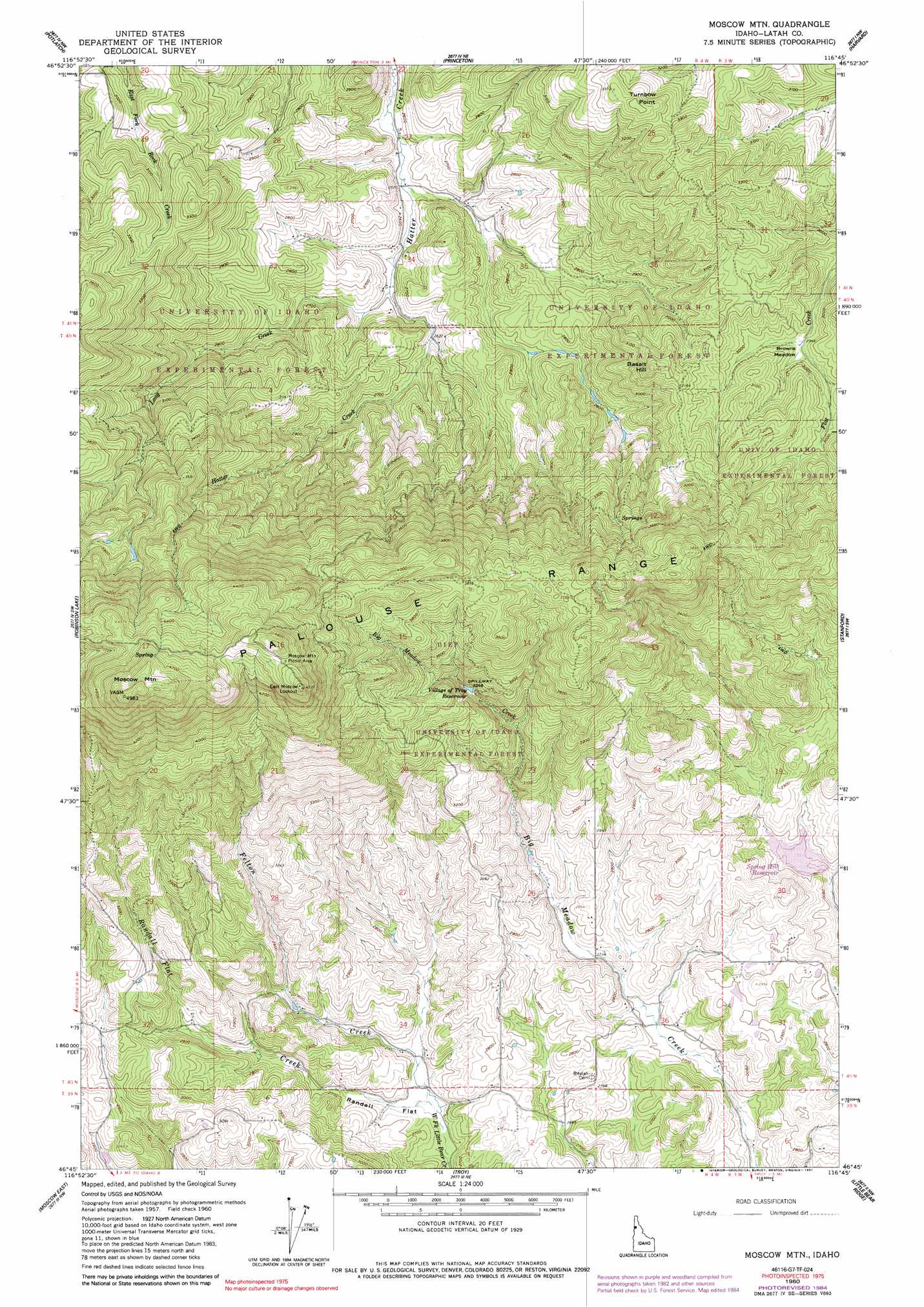
USGS Topo Quad 46116g7 - 1:24,000 scale
| Topo Map Name: | Moscow Mountain |
| USGS Topo Quad ID: | 46116g7 |
| Print Size: | ca. 21 1/4" wide x 27" high |
| Southeast Coordinates: | 46.75° N latitude / 116.75° W longitude |
| Map Center Coordinates: | 46.8125° N latitude / 116.8125° W longitude |
| U.S. State: | ID |
| Filename: | o46116g7.jpg |
| Download Map JPG Image: | Moscow Mountain topo map 1:24,000 scale |
| Map Type: | Topographic |
| Topo Series: | 7.5´ |
| Map Scale: | 1:24,000 |
| Source of Map Images: | United States Geological Survey (USGS) |
| Alternate Map Versions: |
Moscow Mtn ID 1960, updated 1961 Download PDF Buy paper map Moscow Mtn ID 1960, updated 1977 Download PDF Buy paper map Moscow Mtn ID 1960, updated 1982 Download PDF Buy paper map Moscow Mtn ID 1960, updated 1984 Download PDF Buy paper map Moscow Mountain ID 1960, updated 1991 Download PDF Buy paper map Moscow Mountain ID 1994, updated 1997 Download PDF Buy paper map Moscow Mountain ID 2011 Download PDF Buy paper map Moscow Mountain ID 2014 Download PDF Buy paper map |
| FStopo: | US Forest Service topo Moscow Mountain is available: Download FStopo PDF Download FStopo TIF |
1:24,000 Topo Quads surrounding Moscow Mountain
Farmington |
Mission Mountain |
Sanders |
West Dennis |
Emida |
Palouse |
Potlatch |
Princeton |
Harvard |
Sand Mountain |
Viola |
Robinson Lake |
Moscow Mountain |
Stanford |
Deary |
Moscow West |
Moscow East |
Troy |
Little Bear Ridge |
Texas Ridge |
Uniontown |
Genesee |
Green Knob |
Juliaetta |
Lenore |
> Back to 46116e1 at 1:100,000 scale
> Back to 46116a1 at 1:250,000 scale
> Back to U.S. Topo Maps home
Moscow Mountain topo map: Gazetteer
Moscow Mountain: Dams
Spring Valley Dam elevation 836m 2742′Troy Dam elevation 989m 3244′
Moscow Mountain: Flats
Browns Meadow elevation 900m 2952′Randall Flat elevation 816m 2677′
Moscow Mountain: Ranges
Palouse Range elevation 1441m 4727′Moscow Mountain: Reservoirs
Spring Hill Reservoir elevation 844m 2769′Spring Valley Reservoir elevation 836m 2742′
Village of Troy Reservoir elevation 989m 3244′
Moscow Mountain: Streams
Bergs Creek elevation 834m 2736′Felton Creek elevation 804m 2637′
Long Creek elevation 791m 2595′
Randall Flat Creek elevation 804m 2637′
Moscow Mountain: Summits
Basalt Hill elevation 1004m 3293′East Moscow Mountain elevation 1437m 4714′
Moscow Mountain elevation 1520m 4986′
Turnbow Point elevation 1040m 3412′
Moscow Mountain digital topo map on disk
Buy this Moscow Mountain topo map showing relief, roads, GPS coordinates and other geographical features, as a high-resolution digital map file on DVD: