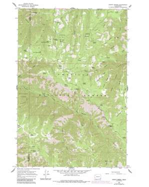
Stentz Spring Topo Map Washington
To zoom in, hover over the map of Stentz Spring
USGS Topo Quad 46117b5 - 1:24,000 scale
| Topo Map Name: | Stentz Spring |
| USGS Topo Quad ID: | 46117b5 |
| Print Size: | ca. 21 1/4" wide x 27" high |
| Southeast Coordinates: | 46.125° N latitude / 117.5° W longitude |
| Map Center Coordinates: | 46.1875° N latitude / 117.5625° W longitude |
| U.S. State: | WA |
| Filename: | o46117b5.jpg |
| Download Map JPG Image: | Stentz Spring topo map 1:24,000 scale |
| Map Type: | Topographic |
| Topo Series: | 7.5´ |
| Map Scale: | 1:24,000 |
| Source of Map Images: | United States Geological Survey (USGS) |
| Alternate Map Versions: |
Stentz Spring WA 1967, updated 1971 Download PDF Buy paper map Stentz Spring WA 1967, updated 1983 Download PDF Buy paper map Stentz Spring WA 1967, updated 1991 Download PDF Buy paper map Stentz Spring WA 1995, updated 1998 Download PDF Buy paper map Stentz Spring WA 2011 Download PDF Buy paper map Stentz Spring WA 2013 Download PDF Buy paper map |
| FStopo: | US Forest Service topo Stentz Spring is available: Download FStopo PDF Download FStopo TIF |
1:24,000 Topo Quads surrounding Stentz Spring
> Back to 46117a1 at 1:100,000 scale
> Back to 46116a1 at 1:250,000 scale
> Back to U.S. Topo Maps home
Stentz Spring topo map: Gazetteer
Stentz Spring: Flats
Elk Flat elevation 1801m 5908′Sunflower Flat elevation 1660m 5446′
Stentz Spring: Parks
Tucannon Game Reserve (historical) elevation 1504m 4934′Stentz Spring: Populated Places
Stentz Spring elevation 1563m 5127′Stentz Spring: Ridges
Bear Cave Ridge elevation 1688m 5538′Bear Ridge elevation 1845m 6053′
Buckley Ridge elevation 1848m 6062′
Cougar Ridge elevation 1723m 5652′
Devils Eyebrow elevation 1682m 5518′
Lost Point Ridge elevation 1601m 5252′
Lost Ridge elevation 1591m 5219′
Unfried Ridge elevation 1551m 5088′
Stentz Spring: Springs
Bear Willow Spring elevation 1785m 5856′Big Bear Willow Spring elevation 1623m 5324′
Big Spring elevation 1564m 5131′
Buck Spring elevation 1669m 5475′
Clover Spring elevation 1802m 5912′
Cougar Spring elevation 1754m 5754′
Deadhead Spring elevation 1851m 6072′
Dodge Spring elevation 1700m 5577′
Double Spring elevation 1693m 5554′
Elk Spring elevation 1547m 5075′
Hunter Spring elevation 1720m 5643′
Jelly Spring elevation 1654m 5426′
Little Bear Willow Spring elevation 1582m 5190′
Lost Trail Spring elevation 1826m 5990′
Misery Spring elevation 1830m 6003′
Panther Spring elevation 1597m 5239′
Pole Manger Spring elevation 1593m 5226′
Powell Spring elevation 1502m 4927′
Schneckloth Spring elevation 1588m 5209′
Spout Spring elevation 1601m 5252′
Spruce Spring elevation 1735m 5692′
Stentz Spring elevation 1573m 5160′
Sweeney Spring elevation 1559m 5114′
Tamarack Spring elevation 1651m 5416′
Teal Spring elevation 1719m 5639′
Stentz Spring: Streams
Bear Creek elevation 1238m 4061′Sheep Creek elevation 1061m 3480′
Stentz Spring: Summits
Bear Wallow elevation 1639m 5377′Huckleberry Butte elevation 1624m 5328′
Lost Point elevation 1529m 5016′
Stentz Spring: Trails
Bear Creek Trail elevation 1721m 5646′Tucannon River Trail elevation 1204m 3950′
Stentz Spring: Valleys
Cougar Canyon elevation 1320m 4330′Stentz Spring digital topo map on disk
Buy this Stentz Spring topo map showing relief, roads, GPS coordinates and other geographical features, as a high-resolution digital map file on DVD:


