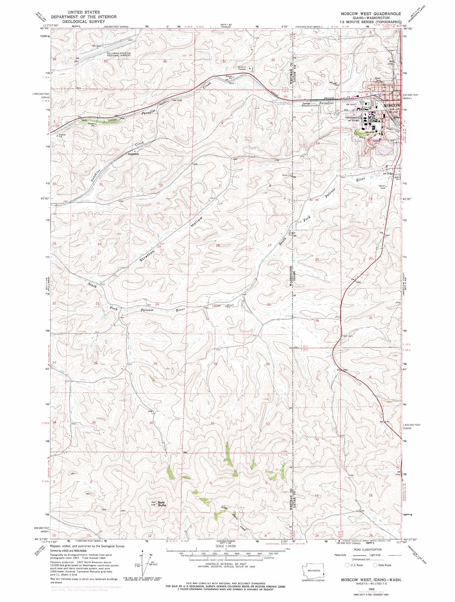
Moscow West Topo Map Washington
To zoom in, hover over the map of Moscow West
USGS Topo Quad 46117f1 - 1:24,000 scale
| Topo Map Name: | Moscow West |
| USGS Topo Quad ID: | 46117f1 |
| Print Size: | ca. 21 1/4" wide x 27" high |
| Southeast Coordinates: | 46.625° N latitude / 117° W longitude |
| Map Center Coordinates: | 46.6875° N latitude / 117.0625° W longitude |
| U.S. States: | WA, ID |
| Filename: | o46117f1.jpg |
| Download Map JPG Image: | Moscow West topo map 1:24,000 scale |
| Map Type: | Topographic |
| Topo Series: | 7.5´ |
| Map Scale: | 1:24,000 |
| Source of Map Images: | United States Geological Survey (USGS) |
| Alternate Map Versions: |
Moscow West ID 1964, updated 1965 Download PDF Buy paper map Moscow West ID 1964, updated 1978 Download PDF Buy paper map Moscow West ID 1964, updated 1978 Download PDF Buy paper map Moscow West ID 1975, updated 1976 Download PDF Buy paper map Moscow West ID 1975, updated 1977 Download PDF Buy paper map Moscow West ID 2011 Download PDF Buy paper map Moscow West ID 2013 Download PDF Buy paper map |
1:24,000 Topo Quads surrounding Moscow West
Colfax North |
Elberton |
Palouse |
Potlatch |
Princeton |
Colfax South |
Albion |
Viola |
Robinson Lake |
Moscow Mountain |
Ewartsville |
Pullman |
Moscow West |
Moscow East |
Troy |
Granite Point |
Colton |
Uniontown |
Genesee |
Green Knob |
Stember Creek |
Silcott Island |
Clarkston |
Lewiston Orchards North |
Lapwai |
> Back to 46117e1 at 1:100,000 scale
> Back to 46116a1 at 1:250,000 scale
> Back to U.S. Topo Maps home
Moscow West topo map: Gazetteer
Moscow West: Airports
Pullman-Moscow Regional Airport elevation 771m 2529′University of Idaho Heliport elevation 794m 2604′
Moscow West: Parks
Neale Stadium (historical) elevation 795m 2608′Moscow West: Populated Places
Moscow elevation 786m 2578′Sunshine elevation 789m 2588′
Moscow West: Summits
Bald Butte elevation 1047m 3435′Moscow West: Valleys
Stratton Hollow elevation 750m 2460′Moscow West digital topo map on disk
Buy this Moscow West topo map showing relief, roads, GPS coordinates and other geographical features, as a high-resolution digital map file on DVD: