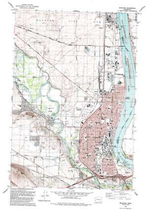
Richland Topo Map Washington
To zoom in, hover over the map of Richland
USGS Topo Quad 46119c3 - 1:24,000 scale
| Topo Map Name: | Richland |
| USGS Topo Quad ID: | 46119c3 |
| Print Size: | ca. 21 1/4" wide x 27" high |
| Southeast Coordinates: | 46.25° N latitude / 119.25° W longitude |
| Map Center Coordinates: | 46.3125° N latitude / 119.3125° W longitude |
| U.S. State: | WA |
| Filename: | o46119c3.jpg |
| Download Map JPG Image: | Richland topo map 1:24,000 scale |
| Map Type: | Topographic |
| Topo Series: | 7.5´ |
| Map Scale: | 1:24,000 |
| Source of Map Images: | United States Geological Survey (USGS) |
| Alternate Map Versions: |
Richland WA 1978, updated 1978 Download PDF Buy paper map Richland WA 1992, updated 1992 Download PDF Buy paper map Richland WA 2011 Download PDF Buy paper map Richland WA 2014 Download PDF Buy paper map |
1:24,000 Topo Quads surrounding Richland
> Back to 46119a1 at 1:100,000 scale
> Back to 46118a1 at 1:250,000 scale
> Back to U.S. Topo Maps home
Richland topo map: Gazetteer
Richland: Airports
Richland Airport elevation 118m 387′Richland: Bridges
Twin Bridges elevation 118m 387′Richland: Canals
Horn Rapids Ditch elevation 131m 429′Richland: Islands
Fox Island elevation 112m 367′Nelson Island elevation 106m 347′
Richland: Parks
Chamna Natural Preserve elevation 106m 347′Columbia Point Marina Park elevation 109m 357′
Howard Amon Park elevation 109m 357′
James J Lawless Park elevation 110m 360′
Jefferson Park elevation 108m 354′
Leslie Groves Park elevation 109m 357′
Paul Liddell Park elevation 126m 413′
Riverview Natural Preserve elevation 107m 351′
W E Johnson Park elevation 111m 364′
Westwood Park elevation 119m 390′
Richland: Populated Places
Richland elevation 117m 383′West Richland elevation 126m 413′
Richland: Summits
Candy Mountain elevation 425m 1394′Flat Top Hill elevation 231m 757′
Richland digital topo map on disk
Buy this Richland topo map showing relief, roads, GPS coordinates and other geographical features, as a high-resolution digital map file on DVD:


