Naches Topo Map Washington
To zoom in, hover over the map of Naches
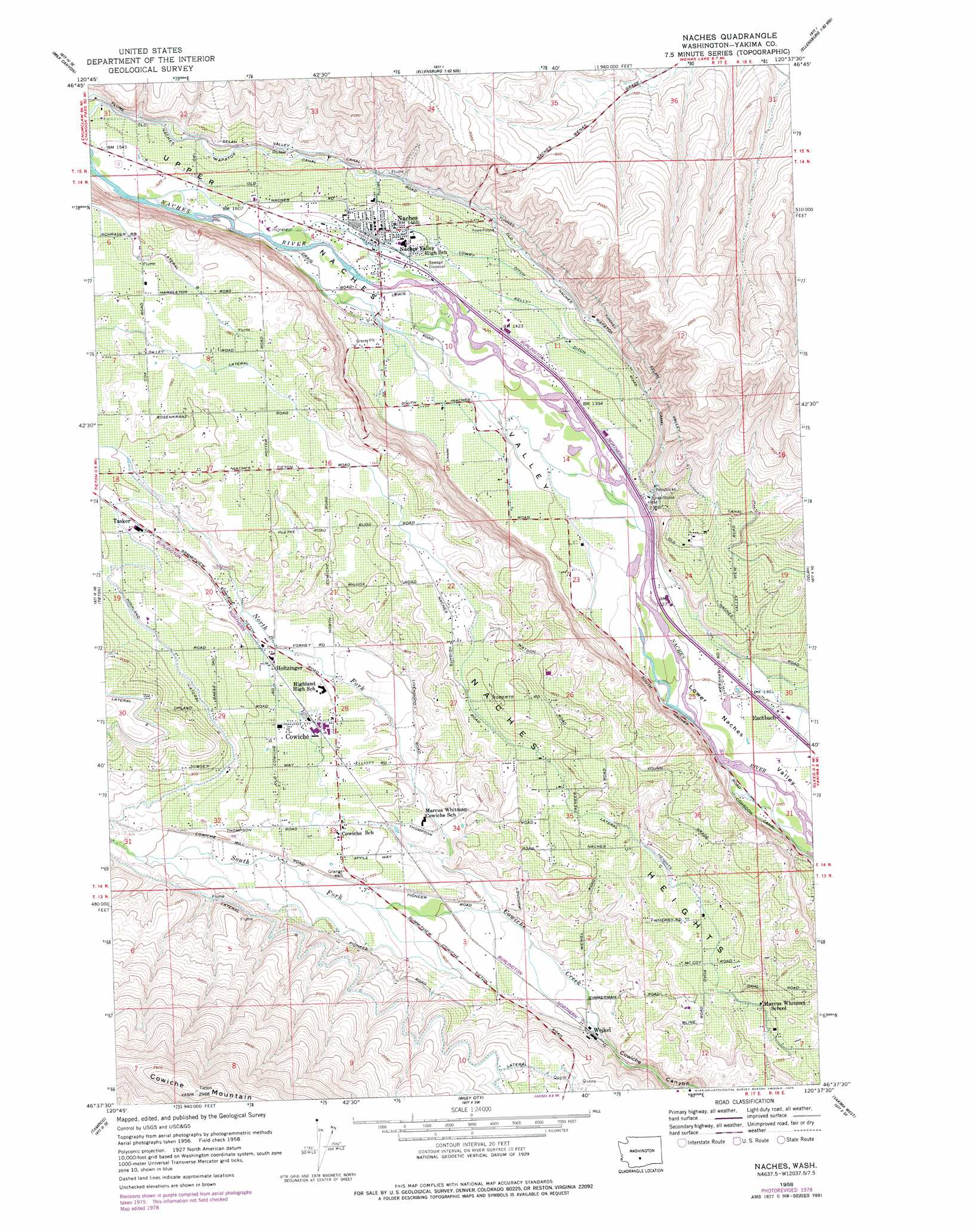
USGS Topo Quad 46120f6 - 1:24,000 scale
| Topo Map Name: | Naches |
| USGS Topo Quad ID: | 46120f6 |
| Print Size: | ca. 21 1/4" wide x 27" high |
| Southeast Coordinates: | 46.625° N latitude / 120.625° W longitude |
| Map Center Coordinates: | 46.6875° N latitude / 120.6875° W longitude |
| U.S. State: | WA |
| Filename: | o46120f6.jpg |
| Download Map JPG Image: | Naches topo map 1:24,000 scale |
| Map Type: | Topographic |
| Topo Series: | 7.5´ |
| Map Scale: | 1:24,000 |
| Source of Map Images: | United States Geological Survey (USGS) |
| Alternate Map Versions: |
Naches WA 1958, updated 1960 Download PDF Buy paper map Naches WA 1958, updated 1978 Download PDF Buy paper map Naches WA 2011 Download PDF Buy paper map Naches WA 2013 Download PDF Buy paper map |
1:24,000 Topo Quads surrounding Naches
Manastash Lake |
Hudson Creek |
Manastash Creek |
Ellensburg South |
Kittitas |
Nile |
Milk Canyon |
Wenas Lake |
The Cottonwoods |
Wymer |
Weddle Canyon |
Tieton |
Naches |
Selah |
Pomona |
Pine Mountain |
Tampico |
Wiley City |
Yakima West |
Yakima East |
Yesmowit Canyon |
Medicine Valley |
White Swan |
Harrah |
Wapato |
> Back to 46120e1 at 1:100,000 scale
> Back to 46120a1 at 1:250,000 scale
> Back to U.S. Topo Maps home
Naches topo map: Gazetteer
Naches: Canals
Kelly Ditch elevation 438m 1437′Lateral C elevation 543m 1781′
Lateral C elevation 597m 1958′
Lateral G elevation 570m 1870′
Lateral J elevation 543m 1781′
Lowry Ditch elevation 446m 1463′
Selah Valley Canal elevation 486m 1594′
Wapatox Canal elevation 481m 1578′
Naches: Populated Places
Cowiche elevation 533m 1748′Eschbach elevation 395m 1295′
Holtzinger elevation 537m 1761′
Naches elevation 449m 1473′
Tasker elevation 570m 1870′
Weikel elevation 458m 1502′
Naches: Streams
North Fork Cowiche Creek elevation 481m 1578′South Fork Cowiche Creek elevation 481m 1578′
Naches: Summits
Naches Heights elevation 532m 1745′Naches: Valleys
Upper Naches Valley elevation 401m 1315′Naches digital topo map on disk
Buy this Naches topo map showing relief, roads, GPS coordinates and other geographical features, as a high-resolution digital map file on DVD: