Ellensburg South Topo Map Washington
To zoom in, hover over the map of Ellensburg South
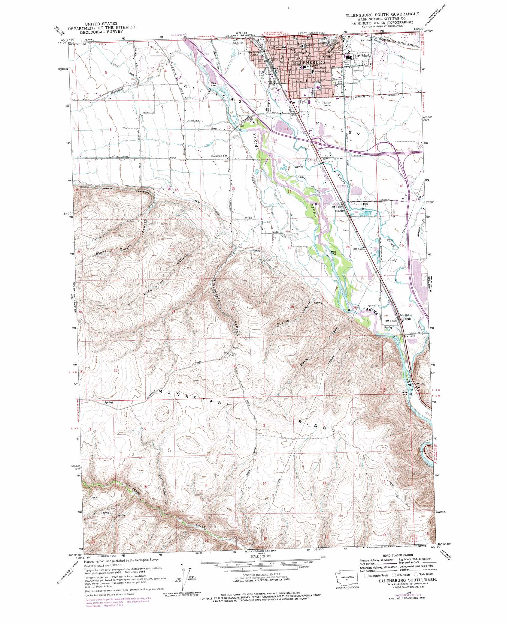
USGS Topo Quad 46120h5 - 1:24,000 scale
| Topo Map Name: | Ellensburg South |
| USGS Topo Quad ID: | 46120h5 |
| Print Size: | ca. 21 1/4" wide x 27" high |
| Southeast Coordinates: | 46.875° N latitude / 120.5° W longitude |
| Map Center Coordinates: | 46.9375° N latitude / 120.5625° W longitude |
| U.S. State: | WA |
| Filename: | o46120h5.jpg |
| Download Map JPG Image: | Ellensburg South topo map 1:24,000 scale |
| Map Type: | Topographic |
| Topo Series: | 7.5´ |
| Map Scale: | 1:24,000 |
| Source of Map Images: | United States Geological Survey (USGS) |
| Alternate Map Versions: |
Ellensburg South WA 1958, updated 1959 Download PDF Buy paper map Ellensburg South WA 1958, updated 1974 Download PDF Buy paper map Ellensburg South WA 1958, updated 1978 Download PDF Buy paper map Ellensburg South WA 1958, updated 1978 Download PDF Buy paper map Ellensburg South WA 2011 Download PDF Buy paper map Ellensburg South WA 2013 Download PDF Buy paper map |
1:24,000 Topo Quads surrounding Ellensburg South
Teanaway |
Swauk Prairie |
Reecer Canyon |
Naneum Canyon |
Colockum Pass |
Taneum Canyon |
Thorp |
Ellensburg North |
Colockum Pass Sw |
Colockum Pass Se |
Hudson Creek |
Manastash Creek |
Ellensburg South |
Kittitas |
East Kittitas |
Milk Canyon |
Wenas Lake |
The Cottonwoods |
Wymer |
Badger Gap |
Tieton |
Naches |
Selah |
Pomona |
Selah Springs |
> Back to 46120e1 at 1:100,000 scale
> Back to 46120a1 at 1:250,000 scale
> Back to U.S. Topo Maps home
Ellensburg South topo map: Gazetteer
Ellensburg South: Canals
Bull Ditch elevation 452m 1482′Clinesmith Irrigation Ditch elevation 458m 1502′
Fogarty Ditch elevation 451m 1479′
Tjossem Ditch elevation 449m 1473′
Town Canal elevation 485m 1591′
Ellensburg South: Crossings
Interstate Eighty-two Interchange elevation 456m 1496′South Ellensburg Interchange elevation 452m 1482′
Ellensburg South: Dams
Tjossem Pond Dam elevation 447m 1466′Ellensburg South: Parks
Memorial Park elevation 479m 1571′Mountain View Park elevation 467m 1532′
Reed Park elevation 468m 1535′
West Side Park elevation 461m 1512′
Whitney Park elevation 474m 1555′
Ellensburg South: Populated Places
Ellensburg elevation 470m 1541′Holmes elevation 446m 1463′
Thrall elevation 437m 1433′
Ellensburg South: Reservoirs
Tjossem Pond elevation 447m 1466′Ellensburg South: Streams
Cherry Creek elevation 439m 1440′Manastash Creek elevation 464m 1522′
Mercer Creek elevation 458m 1502′
Naneum Creek elevation 437m 1433′
Reecer Creek elevation 462m 1515′
Wilson Creek elevation 434m 1423′
Ellensburg South: Summits
Craigs Hill elevation 497m 1630′Ellensburg South: Trails
Davis Trail elevation 782m 2565′Ellensburg South: Valleys
Benwy Canyon elevation 452m 1482′Long Tom Canyon elevation 501m 1643′
Shushuskin Canyon elevation 488m 1601′
Spring Canyon elevation 457m 1499′
Stone Quarry Canyon elevation 519m 1702′
Ellensburg South digital topo map on disk
Buy this Ellensburg South topo map showing relief, roads, GPS coordinates and other geographical features, as a high-resolution digital map file on DVD: