Mount Adams East Topo Map Washington
To zoom in, hover over the map of Mount Adams East
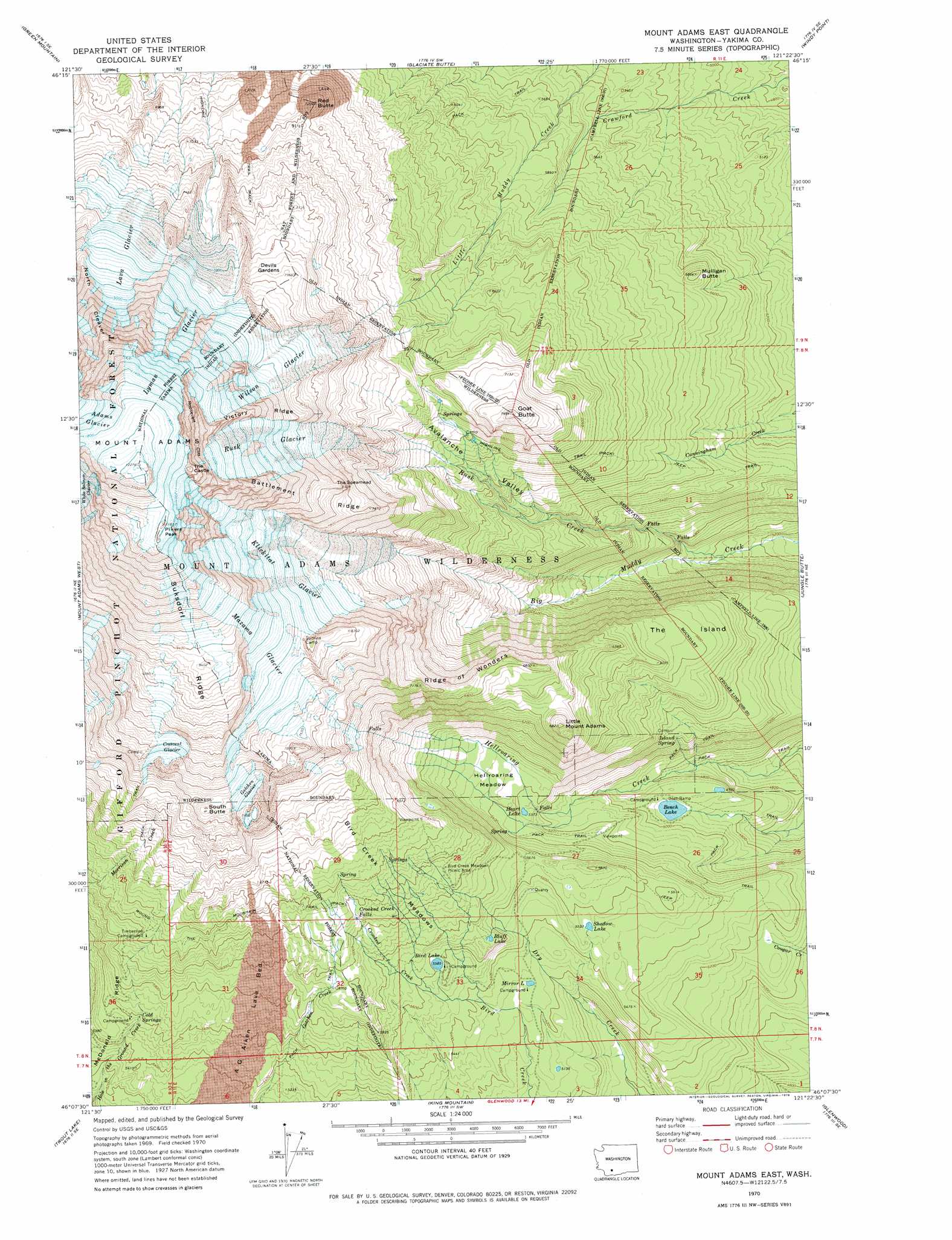
USGS Topo Quad 46121b4 - 1:24,000 scale
| Topo Map Name: | Mount Adams East |
| USGS Topo Quad ID: | 46121b4 |
| Print Size: | ca. 21 1/4" wide x 27" high |
| Southeast Coordinates: | 46.125° N latitude / 121.375° W longitude |
| Map Center Coordinates: | 46.1875° N latitude / 121.4375° W longitude |
| U.S. State: | WA |
| Filename: | o46121b4.jpg |
| Download Map JPG Image: | Mount Adams East topo map 1:24,000 scale |
| Map Type: | Topographic |
| Topo Series: | 7.5´ |
| Map Scale: | 1:24,000 |
| Source of Map Images: | United States Geological Survey (USGS) |
| Alternate Map Versions: |
Mount Adams East WA 1970, updated 1974 Download PDF Buy paper map Mount Adams East WA 1970, updated 1978 Download PDF Buy paper map Mount Adams East WA 1998, updated 2003 Download PDF Buy paper map Mount Adams East WA 2011 Download PDF Buy paper map Mount Adams East WA 2014 Download PDF Buy paper map |
| FStopo: | US Forest Service topo Mount Adams East is available: Download FStopo PDF Download FStopo TIF |
1:24,000 Topo Quads surrounding Mount Adams East
Blue Lake |
Hamilton Buttes |
Walupt Lake |
Jennies Butte |
Fairview Ridge |
East Canyon Ridge |
Green Mountain |
Glaciate Butte |
Windy Point |
Castile Falls |
Steamboat Mountain |
Mount Adams West |
Mount Adams East |
Jungle Butte |
Signal Peak |
Sleeping Beauty |
Trout Lake |
King Mountain |
Glenwood |
Outlet Falls |
Little Huckleberry Mountain |
Guler Mountain |
Quigley Butte |
Camas Prairie |
Dead Canyon |
> Back to 46121a1 at 1:100,000 scale
> Back to 46120a1 at 1:250,000 scale
> Back to U.S. Topo Maps home
Mount Adams East topo map: Gazetteer
Mount Adams East: Areas
Devils Gardens elevation 2413m 7916′Mount Adams East: Cliffs
Roosevelt Cliff elevation 3269m 10725′Mount Adams East: Falls
Crooked Creek Falls elevation 1872m 6141′Mount Adams East: Flats
Bird Creek Meadows elevation 1896m 6220′Hellroaring Meadow elevation 1664m 5459′
Mount Adams East: Glaciers
Crescent Glacier elevation 2529m 8297′Gotchen Glacier elevation 2311m 7582′
Klickitat Glacier elevation 2509m 8231′
Lava Glacier elevation 2558m 8392′
Lyman Glacier elevation 3012m 9881′
Mazama Glacier elevation 2681m 8795′
Rusk Glacier elevation 2637m 8651′
Wilson Glacier elevation 2567m 8421′
Mount Adams East: Lakes
Bench Lake elevation 1496m 4908′Bird Lake elevation 1706m 5597′
Bluff Lake elevation 1741m 5711′
Heart Lake elevation 1638m 5374′
Mirror Lake elevation 1605m 5265′
Shadow Lake elevation 1693m 5554′
Mount Adams East: Pillars
The Castle elevation 3488m 11443′Mount Adams East: Ridges
Battlement Ridge elevation 2494m 8182′North Cleaver elevation 2896m 9501′
Ridge of Wonders elevation 2142m 7027′
Suksdorf Ridge elevation 2866m 9402′
The Spearhead elevation 2507m 8225′
Victory Ridge elevation 2870m 9416′
Mount Adams East: Springs
Cold Springs elevation 1697m 5567′Island Spring elevation 1586m 5203′
Mount Adams East: Streams
Crooked Creek elevation 1666m 5465′Rusk Creek elevation 1322m 4337′
Mount Adams East: Summits
Goat Butte elevation 2256m 7401′Little Mount Adams elevation 2065m 6774′
Mount Adams elevation 3745m 12286′
Mulligan Butte elevation 1781m 5843′
Pikers Peak elevation 3535m 11597′
Red Butte elevation 2171m 7122′
South Butte elevation 2378m 7801′
Mount Adams East: Valleys
Avalanche Valley elevation 1388m 4553′Mount Adams East digital topo map on disk
Buy this Mount Adams East topo map showing relief, roads, GPS coordinates and other geographical features, as a high-resolution digital map file on DVD: