Pinegrass Ridge Topo Map Washington
To zoom in, hover over the map of Pinegrass Ridge
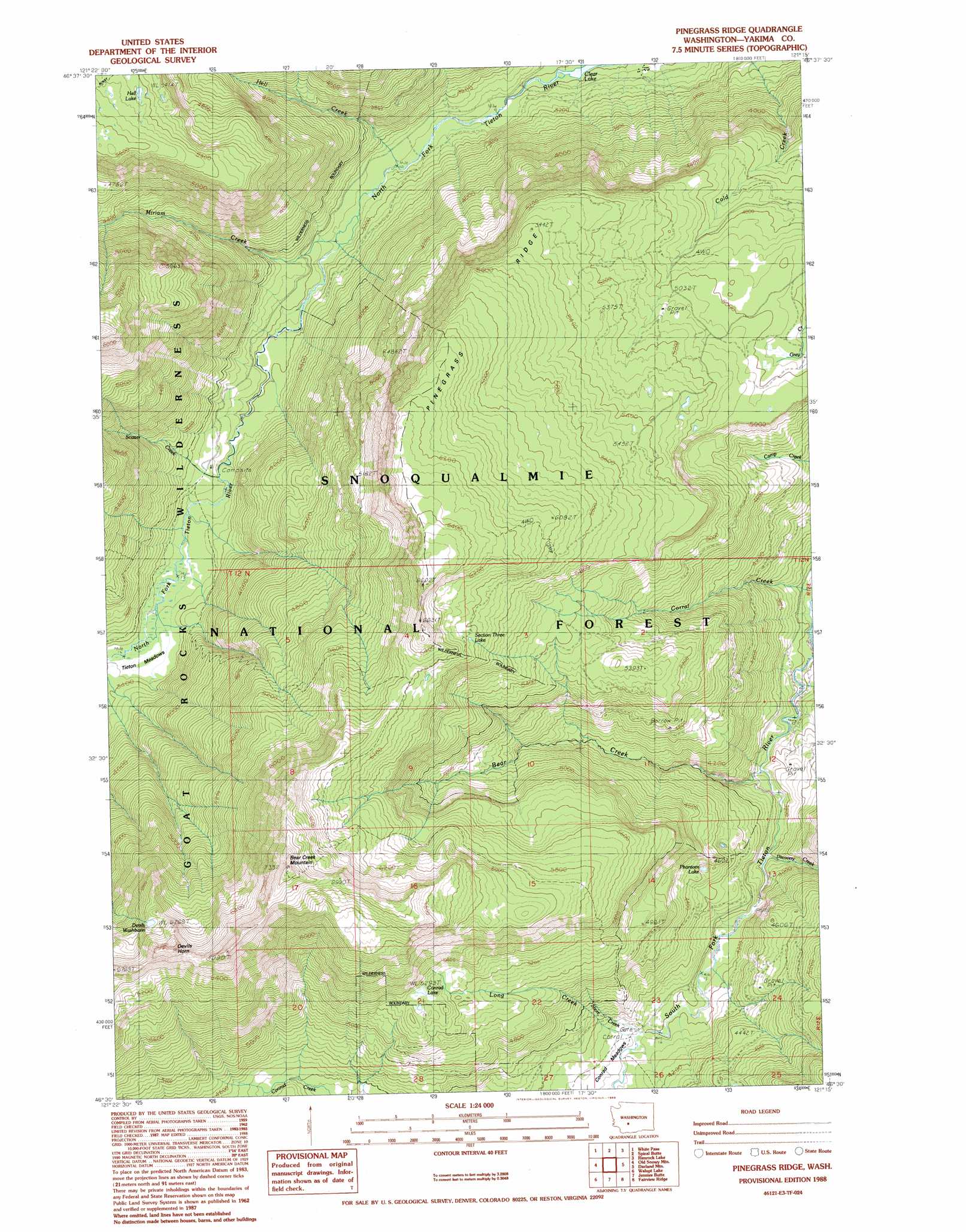
USGS Topo Quad 46121e3 - 1:24,000 scale
| Topo Map Name: | Pinegrass Ridge |
| USGS Topo Quad ID: | 46121e3 |
| Print Size: | ca. 21 1/4" wide x 27" high |
| Southeast Coordinates: | 46.5° N latitude / 121.25° W longitude |
| Map Center Coordinates: | 46.5625° N latitude / 121.3125° W longitude |
| U.S. State: | WA |
| Filename: | o46121e3.jpg |
| Download Map JPG Image: | Pinegrass Ridge topo map 1:24,000 scale |
| Map Type: | Topographic |
| Topo Series: | 7.5´ |
| Map Scale: | 1:24,000 |
| Source of Map Images: | United States Geological Survey (USGS) |
| Alternate Map Versions: |
Pinegrass Ridge WA 1988, updated 1989 Download PDF Buy paper map Pinegrass Ridge WA 2000, updated 2001 Download PDF Buy paper map Pinegrass Ridge WA 2011 Download PDF Buy paper map Pinegrass Ridge WA 2014 Download PDF Buy paper map |
| FStopo: | US Forest Service topo Pinegrass Ridge is available: Download FStopo PDF Download FStopo TIF |
1:24,000 Topo Quads surrounding Pinegrass Ridge
Chinook Pass |
Cougar Lake |
Bumping Lake |
Timberwolf Mountain |
Meeks Table |
Ohanapecosh Hot Springs |
White Pass |
Spiral Butte |
Rimrock Lake |
Tieton Basin |
Packwood Lake |
Old Snowy Mountain |
Pinegrass Ridge |
Darland Mountain |
Foundation Ridge |
Hamilton Buttes |
Walupt Lake |
Jennies Butte |
Fairview Ridge |
Piscoe Meadow |
Green Mountain |
Glaciate Butte |
Windy Point |
Castile Falls |
Lost Horse Plateau |
> Back to 46121e1 at 1:100,000 scale
> Back to 46120a1 at 1:250,000 scale
> Back to U.S. Topo Maps home
Pinegrass Ridge topo map: Gazetteer
Pinegrass Ridge: Basins
Devils Washbasin elevation 1912m 6272′Pinegrass Ridge: Flats
Conrad Meadows elevation 1255m 4117′Tieton Meadows elevation 1023m 3356′
Pinegrass Ridge: Lakes
Conrad Lake elevation 1621m 5318′Hell Lake elevation 1655m 5429′
Phantom Lake elevation 1313m 4307′
Section 3 Lake elevation 1837m 6026′
Pinegrass Ridge: Ridges
Pinegrass Ridge elevation 1776m 5826′Pinegrass Ridge: Streams
Bear Creek elevation 1120m 3674′Discovery Creek elevation 1148m 3766′
Hell Creek elevation 939m 3080′
Long Creek elevation 1223m 4012′
Miriam Creek elevation 950m 3116′
Scatter Creek elevation 1005m 3297′
Short Creek elevation 1223m 4012′
Pinegrass Ridge: Summits
Bear Creek Mountain elevation 2200m 7217′Devils Horn elevation 2125m 6971′
Pinegrass Ridge: Trails
Bear Creek Mountain Trail elevation 1783m 5849′Minnie Meadows Trail elevation 1631m 5351′
North Fork Tieton Trail elevation 974m 3195′
Tieton Meadows Trail elevation 1284m 4212′
Pinegrass Ridge digital topo map on disk
Buy this Pinegrass Ridge topo map showing relief, roads, GPS coordinates and other geographical features, as a high-resolution digital map file on DVD: