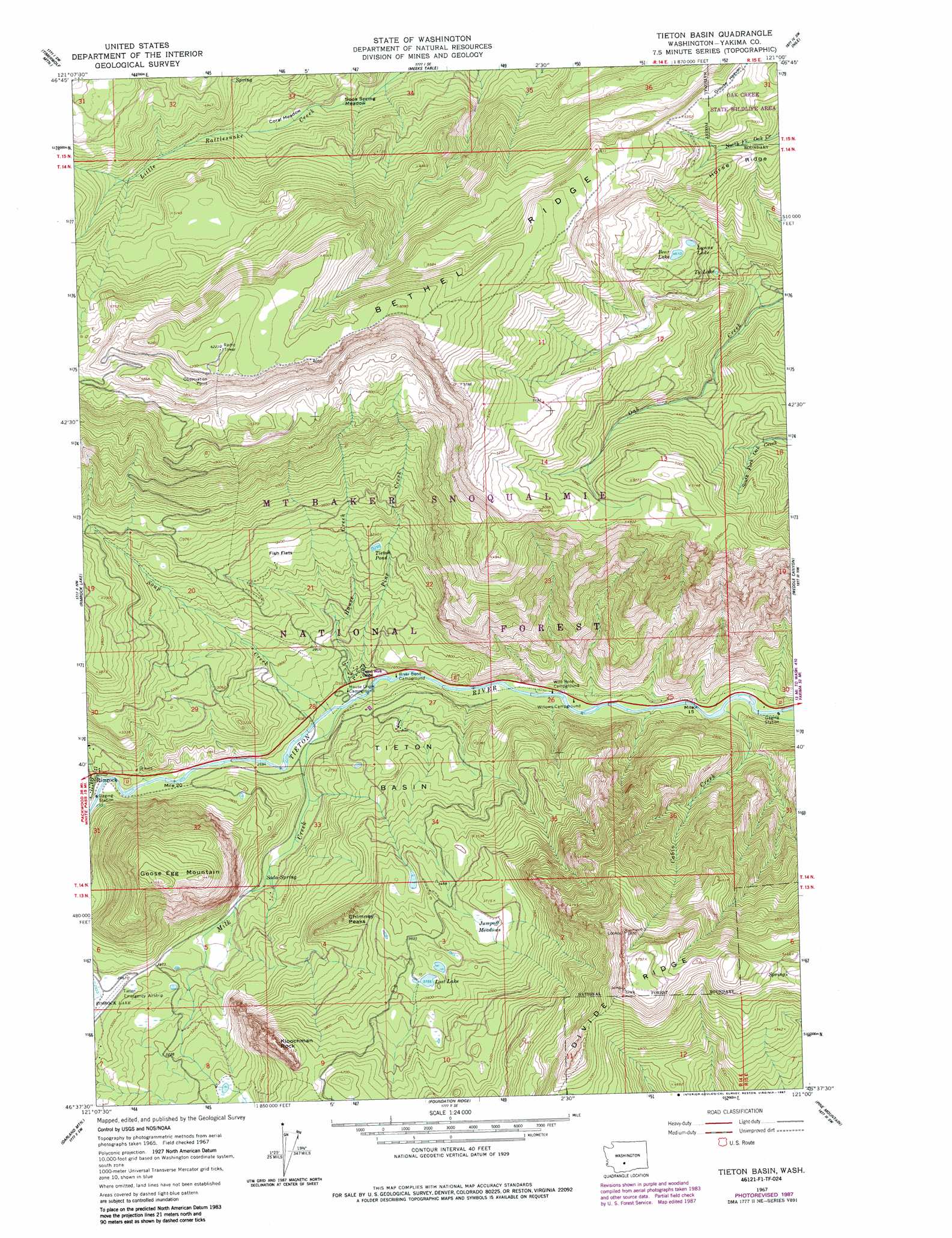
Tieton Basin Topo Map Washington
To zoom in, hover over the map of Tieton Basin
USGS Topo Quad 46121f1 - 1:24,000 scale
| Topo Map Name: | Tieton Basin |
| USGS Topo Quad ID: | 46121f1 |
| Print Size: | ca. 21 1/4" wide x 27" high |
| Southeast Coordinates: | 46.625° N latitude / 121° W longitude |
| Map Center Coordinates: | 46.6875° N latitude / 121.0625° W longitude |
| U.S. State: | WA |
| Filename: | o46121f1.jpg |
| Download Map JPG Image: | Tieton Basin topo map 1:24,000 scale |
| Map Type: | Topographic |
| Topo Series: | 7.5´ |
| Map Scale: | 1:24,000 |
| Source of Map Images: | United States Geological Survey (USGS) |
| Alternate Map Versions: |
Tieton Basin WA 1967, updated 1970 Download PDF Buy paper map Tieton Basin WA 1967, updated 1978 Download PDF Buy paper map Tieton Basin WA 1967, updated 1987 Download PDF Buy paper map Tieton Basin WA 1992, updated 1996 Download PDF Buy paper map Tieton Basin WA 2000, updated 2001 Download PDF Buy paper map Tieton Basin WA 2011 Download PDF Buy paper map Tieton Basin WA 2014 Download PDF Buy paper map |
| FStopo: | US Forest Service topo Tieton Basin is available: Download FStopo PDF Download FStopo TIF |
1:24,000 Topo Quads surrounding Tieton Basin
Goose Prairie |
Old Scab Mountain |
Cliffdell |
Manastash Lake |
Hudson Creek |
Bumping Lake |
Timberwolf Mountain |
Meeks Table |
Nile |
Milk Canyon |
Spiral Butte |
Rimrock Lake |
Tieton Basin |
Weddle Canyon |
Tieton |
Pinegrass Ridge |
Darland Mountain |
Foundation Ridge |
Pine Mountain |
Tampico |
Jennies Butte |
Fairview Ridge |
Piscoe Meadow |
Yesmowit Canyon |
Medicine Valley |
> Back to 46121e1 at 1:100,000 scale
> Back to 46120a1 at 1:250,000 scale
> Back to U.S. Topo Maps home
Tieton Basin topo map: Gazetteer
Tieton Basin: Airports
Tieton State Airport elevation 928m 3044′Tieton Basin: Basins
Tieton Basin elevation 888m 2913′Tieton Basin: Flats
Coral Meadow elevation 1252m 4107′Fish Flats elevation 1007m 3303′
Jumpoff Meadows elevation 1095m 3592′
Soda Spring Meadow elevation 1222m 4009′
Tieton Basin: Lakes
Bear Lake elevation 1414m 4639′Lost Lake elevation 1146m 3759′
Lynne Lake elevation 1409m 4622′
Tieton Pond elevation 994m 3261′
Ty Lake elevation 1317m 4320′
Tieton Basin: Pillars
Kloochman Rock elevation 1378m 4520′Tieton Basin: Springs
Soda Spring elevation 828m 2716′Tieton Basin: Streams
Cabin Creek elevation 719m 2358′Hause Creek elevation 771m 2529′
Milk Creek elevation 775m 2542′
Pine Creek elevation 767m 2516′
Soup Creek elevation 780m 2559′
Wildcat Creek elevation 825m 2706′
Tieton Basin: Summits
Chimney Peaks elevation 1153m 3782′Goose Egg Mountain elevation 1381m 4530′
Jump Off Lookout elevation 1666m 5465′
Tieton Basin digital topo map on disk
Buy this Tieton Basin topo map showing relief, roads, GPS coordinates and other geographical features, as a high-resolution digital map file on DVD: