Meeks Table Topo Map Washington
To zoom in, hover over the map of Meeks Table
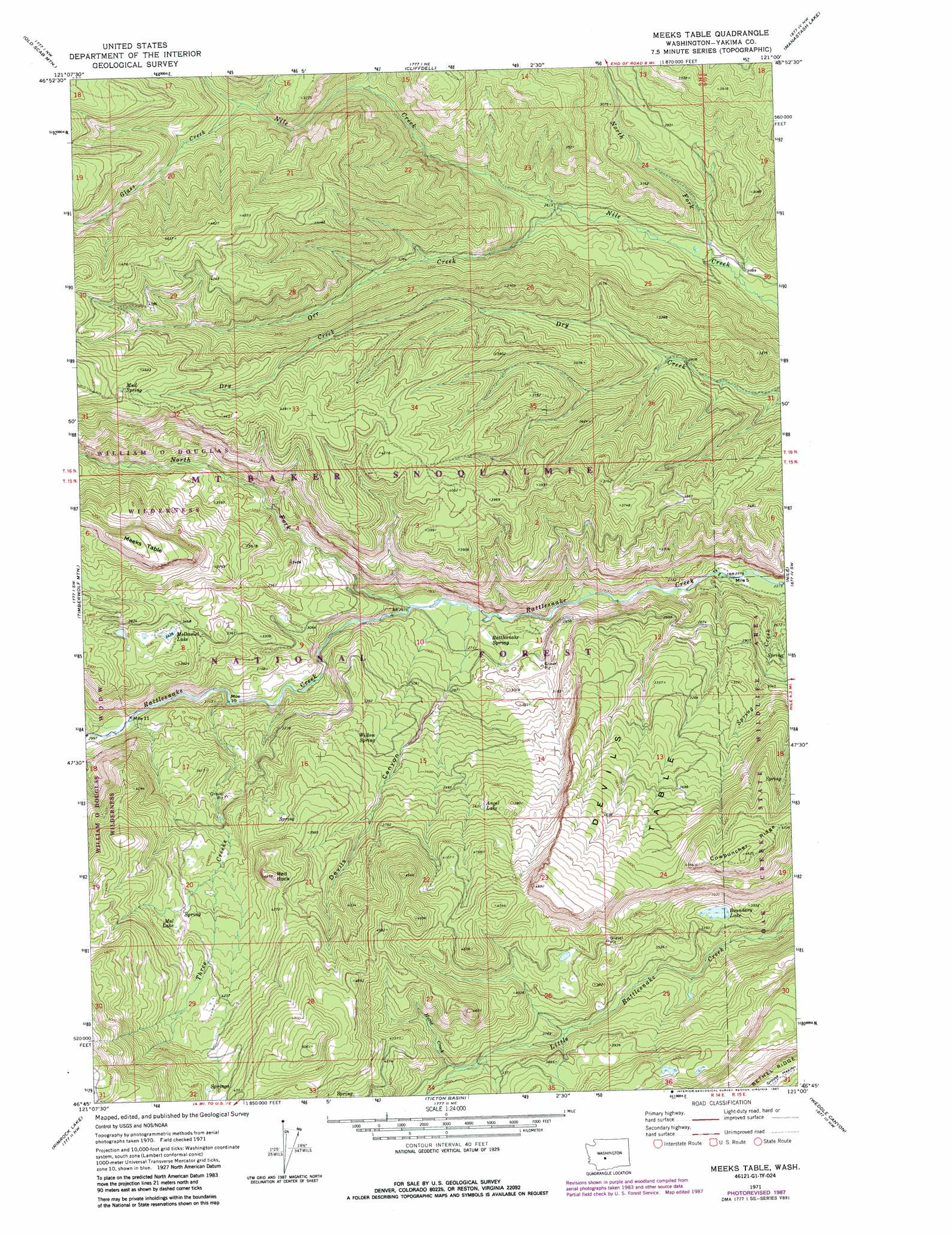
USGS Topo Quad 46121g1 - 1:24,000 scale
| Topo Map Name: | Meeks Table |
| USGS Topo Quad ID: | 46121g1 |
| Print Size: | ca. 21 1/4" wide x 27" high |
| Southeast Coordinates: | 46.75° N latitude / 121° W longitude |
| Map Center Coordinates: | 46.8125° N latitude / 121.0625° W longitude |
| U.S. State: | WA |
| Filename: | o46121g1.jpg |
| Download Map JPG Image: | Meeks Table topo map 1:24,000 scale |
| Map Type: | Topographic |
| Topo Series: | 7.5´ |
| Map Scale: | 1:24,000 |
| Source of Map Images: | United States Geological Survey (USGS) |
| Alternate Map Versions: |
Meeks Table WA 1971, updated 1974 Download PDF Buy paper map Meeks Table WA 1971, updated 1987 Download PDF Buy paper map Meeks Table WA 1992, updated 1996 Download PDF Buy paper map Meeks Table WA 2000, updated 2001 Download PDF Buy paper map Meeks Table WA 2011 Download PDF Buy paper map Meeks Table WA 2014 Download PDF Buy paper map |
| FStopo: | US Forest Service topo Meeks Table is available: Download FStopo PDF Download FStopo TIF |
1:24,000 Topo Quads surrounding Meeks Table
Raven Roost |
Mount Clifty |
Quartz Mountain |
Frost Mountain |
Taneum Canyon |
Goose Prairie |
Old Scab Mountain |
Cliffdell |
Manastash Lake |
Hudson Creek |
Bumping Lake |
Timberwolf Mountain |
Meeks Table |
Nile |
Milk Canyon |
Spiral Butte |
Rimrock Lake |
Tieton Basin |
Weddle Canyon |
Tieton |
Pinegrass Ridge |
Darland Mountain |
Foundation Ridge |
Pine Mountain |
Tampico |
> Back to 46121e1 at 1:100,000 scale
> Back to 46120a1 at 1:250,000 scale
> Back to U.S. Topo Maps home
Meeks Table topo map: Gazetteer
Meeks Table: Areas
Meeks Table Natural Area elevation 1337m 4386′Meeks Table: Flats
Grouse Heaven elevation 1567m 5141′Meeks Table: Lakes
Angel Lake elevation 1109m 3638′Boundary Lake elevation 1021m 3349′
Mal Lake elevation 1241m 4071′
McDaniel Lake elevation 1048m 3438′
Meeks Table: Pillars
Red Rock elevation 1350m 4429′Meeks Table: Springs
Mud Spring elevation 1406m 4612′Rattlesnake Spring elevation 819m 2687′
Willow Spring elevation 1017m 3336′
Meeks Table: Streams
Glass Creek elevation 996m 3267′Horse Creek elevation 1129m 3704′
North Fork Nile Creek elevation 726m 2381′
North Fork Rattlesnake Creek elevation 809m 2654′
Orr Creek elevation 792m 2598′
Spring Creek elevation 715m 2345′
Three Creeks elevation 871m 2857′
Meeks Table: Summits
Devils Table elevation 1430m 4691′Meeks Table elevation 1370m 4494′
Meeks Table: Valleys
Devils Canyon elevation 844m 2769′Meeks Table digital topo map on disk
Buy this Meeks Table topo map showing relief, roads, GPS coordinates and other geographical features, as a high-resolution digital map file on DVD: