White River Park Topo Map Washington
To zoom in, hover over the map of White River Park
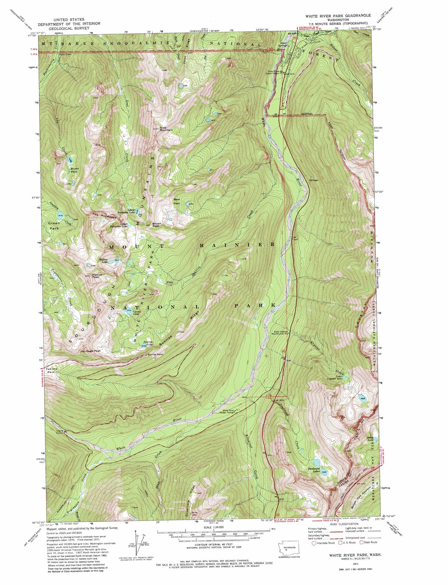
USGS Topo Quad 46121h5 - 1:24,000 scale
| Topo Map Name: | White River Park |
| USGS Topo Quad ID: | 46121h5 |
| Print Size: | ca. 21 1/4" wide x 27" high |
| Southeast Coordinates: | 46.875° N latitude / 121.5° W longitude |
| Map Center Coordinates: | 46.9375° N latitude / 121.5625° W longitude |
| U.S. State: | WA |
| Filename: | o46121h5.jpg |
| Download Map JPG Image: | White River Park topo map 1:24,000 scale |
| Map Type: | Topographic |
| Topo Series: | 7.5´ |
| Map Scale: | 1:24,000 |
| Source of Map Images: | United States Geological Survey (USGS) |
| Alternate Map Versions: |
White River Park WA 1971, updated 1974 Download PDF Buy paper map White River Park WA 1971, updated 1983 Download PDF Buy paper map White River Park WA 1971, updated 1983 Download PDF Buy paper map White River Park WA 2011 Download PDF Buy paper map White River Park WA 2014 Download PDF Buy paper map |
| FStopo: | US Forest Service topo White River Park is available: Download FStopo PDF Download FStopo TIF |
1:24,000 Topo Quads surrounding White River Park
Cyclone Creek |
Greenwater |
Nagrom |
Lester |
Blowout Mountain |
Bearhead Mountain |
Clear West Peak |
Sun Top |
Noble Knob |
Raven Roost |
Mowich Lake |
Sunrise |
White River Park |
Norse Peak |
Goose Prairie |
Mount Rainier West |
Mt Rainier East |
Chinook Pass |
Cougar Lake |
Bumping Lake |
Wahpenayo Peak |
Tatoosh Lakes |
Ohanapecosh Hot Springs |
White Pass |
Spiral Butte |
> Back to 46121e1 at 1:100,000 scale
> Back to 46120a1 at 1:250,000 scale
> Back to U.S. Topo Maps home
White River Park topo map: Gazetteer
White River Park: Cliffs
Sunrise Point elevation 1865m 6118′The Palisades elevation 1908m 6259′
White River Park: Flats
Bear Park elevation 1694m 5557′Burnt Park elevation 1689m 5541′
Green Park elevation 1726m 5662′
White River Park elevation 1658m 5439′
White River Park: Gaps
Sourdough Gap elevation 1956m 6417′White River Park: Lakes
Clover Lake elevation 1748m 5734′Crystal Lake elevation 1778m 5833′
Deadwood Lakes elevation 1597m 5239′
Hidden Lake elevation 1804m 5918′
Lower Crystal Lake elevation 1667m 5469′
Lower Palisades Lake elevation 1676m 5498′
Sheep Lake elevation 1756m 5761′
Sunrise Lake elevation 1746m 5728′
Upper Palisades Lake elevation 1779m 5836′
White River Park: Ridges
Fawn Ridge elevation 1637m 5370′Governors Ridge elevation 1982m 6502′
Sunrise Ridge elevation 1844m 6049′
White River Park: Springs
Silver Springs elevation 804m 2637′White River Park: Streams
Crystal Creek elevation 948m 3110′Deadwood Creek elevation 995m 3264′
Fryingpan Creek elevation 1134m 3720′
Goat Creek elevation 806m 2644′
Klickitat Creek elevation 1003m 3290′
Shaw Creek elevation 1046m 3431′
Silver Creek elevation 797m 2614′
Sunrise Creek elevation 849m 2785′
Wright Creek elevation 1204m 3950′
White River Park: Summits
Brown Peak elevation 1894m 6213′Crystal Mountain elevation 2129m 6984′
Dege Peak elevation 2128m 6981′
Marcus Peak elevation 2092m 6863′
Slide Mountain elevation 1907m 6256′
Sourdough Mountains elevation 1943m 6374′
White River Park digital topo map on disk
Buy this White River Park topo map showing relief, roads, GPS coordinates and other geographical features, as a high-resolution digital map file on DVD: