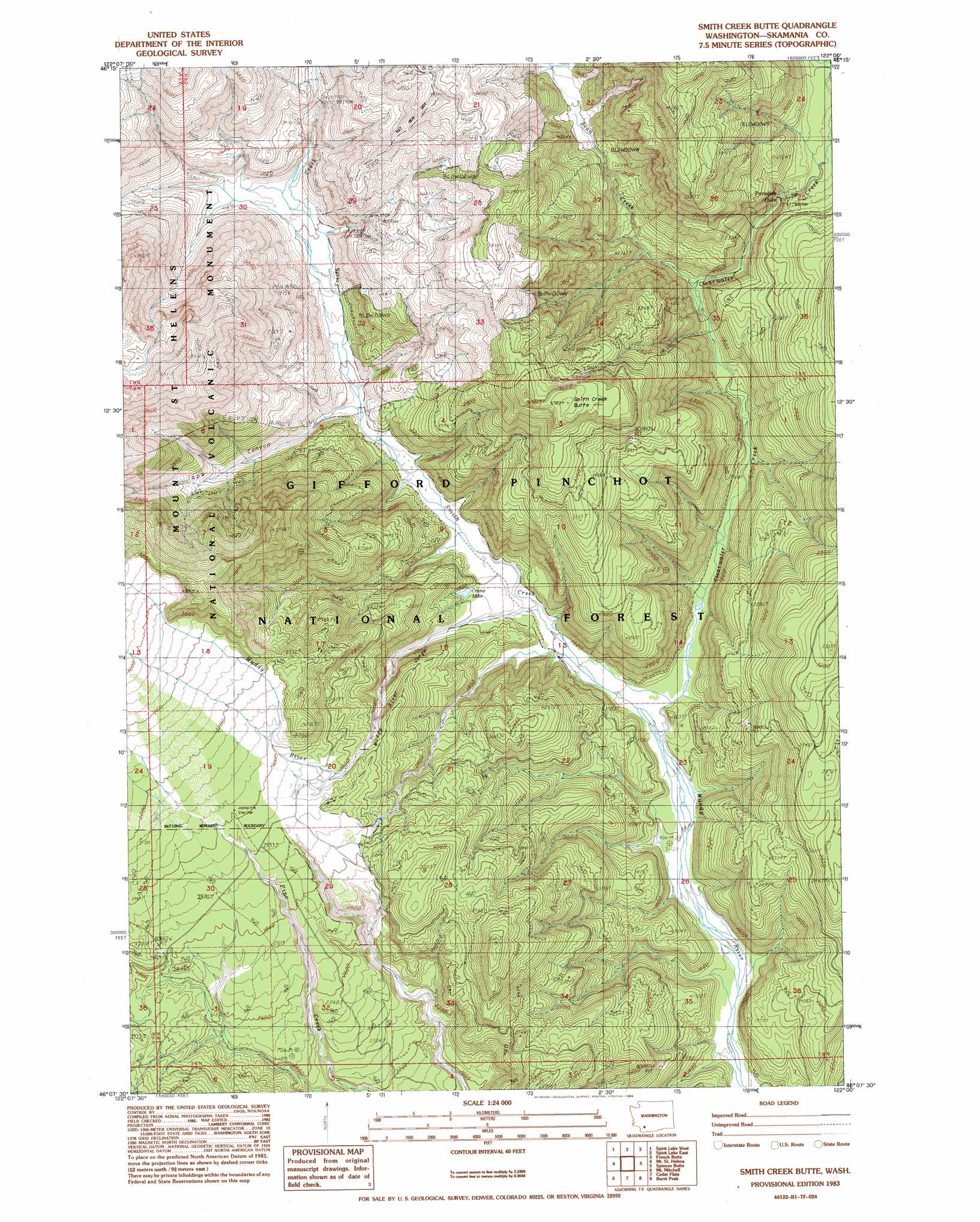
Smith Creek Butte Topo Map Washington
To zoom in, hover over the map of Smith Creek Butte
USGS Topo Quad 46122b1 - 1:24,000 scale
| Topo Map Name: | Smith Creek Butte |
| USGS Topo Quad ID: | 46122b1 |
| Print Size: | ca. 21 1/4" wide x 27" high |
| Southeast Coordinates: | 46.125° N latitude / 122° W longitude |
| Map Center Coordinates: | 46.1875° N latitude / 122.0625° W longitude |
| U.S. State: | WA |
| Filename: | o46122b1.jpg |
| Download Map JPG Image: | Smith Creek Butte topo map 1:24,000 scale |
| Map Type: | Topographic |
| Topo Series: | 7.5´ |
| Map Scale: | 1:24,000 |
| Source of Map Images: | United States Geological Survey (USGS) |
| Alternate Map Versions: |
Mt. St. Helens NE WA 1975, updated 1980 Download PDF Buy paper map Smith Creek Butte WA 1983, updated 1984 Download PDF Buy paper map Smith Creek Butte WA 1998, updated 2003 Download PDF Buy paper map Smith Creek Butte WA 2011 Download PDF Buy paper map Smith Creek Butte WA 2013 Download PDF Buy paper map |
| FStopo: | US Forest Service topo Smith Creek Butte is available: Download FStopo PDF Download FStopo TIF |
1:24,000 Topo Quads surrounding Smith Creek Butte
Winters Mountain |
Vanson Peak |
Cowlitz Falls |
Greenhorn Buttes |
Tower Rock |
Elk Rock |
Spirit Lake West |
Spirit Lake East |
French Butte |
Mccoy Peak |
Goat Mountain |
Mount Sainte Helens |
Smith Creek Butte |
Spencer Butte |
Quartz Creek Butte |
Cougar |
Mount Mitchell |
Cedar Flats |
Burnt Peak |
Lone Butte |
Yale Dam |
Siouxon Peak |
Bare Mountain |
Termination Point |
Gifford Peak |
> Back to 46122a1 at 1:100,000 scale
> Back to 46122a1 at 1:250,000 scale
> Back to U.S. Topo Maps home
Smith Creek Butte topo map: Gazetteer
Smith Creek Butte: Falls
Paradise Falls elevation 603m 1978′Smith Creek Butte: Lakes
Bear Lake elevation 520m 1706′Crane Lake elevation 535m 1755′
Hoo Hoo Lake elevation 500m 1640′
Smith Creek Butte: Streams
Bean Creek elevation 525m 1722′Clearwater Creek elevation 452m 1482′
Smith Creek elevation 496m 1627′
Smith Creek Butte: Summits
Smith Creek Butte elevation 1153m 3782′Smith Creek Butte: Trails
Bean Creek Trail elevation 850m 2788′Muddy River Trail elevation 683m 2240′
Smith Creek Butte Trail elevation 914m 2998′
Smith Creek Trail elevation 655m 2148′
Smith Creek Butte: Valleys
Ape Canyon elevation 539m 1768′Lava Canyon elevation 494m 1620′
Muddy River Gorge elevation 763m 2503′
Smith Creek Butte digital topo map on disk
Buy this Smith Creek Butte topo map showing relief, roads, GPS coordinates and other geographical features, as a high-resolution digital map file on DVD: