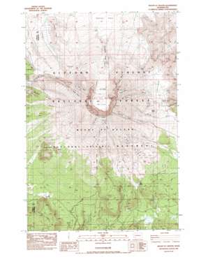
Mount Sainte Helens Topo Map Washington
To zoom in, hover over the map of Mount Sainte Helens
USGS Topo Quad 46122b2 - 1:24,000 scale
| Topo Map Name: | Mount Sainte Helens |
| USGS Topo Quad ID: | 46122b2 |
| Print Size: | ca. 21 1/4" wide x 27" high |
| Southeast Coordinates: | 46.125° N latitude / 122.125° W longitude |
| Map Center Coordinates: | 46.1875° N latitude / 122.1875° W longitude |
| U.S. State: | WA |
| Filename: | o46122b2.jpg |
| Download Map JPG Image: | Mount Sainte Helens topo map 1:24,000 scale |
| Map Type: | Topographic |
| Topo Series: | 7.5´ |
| Map Scale: | 1:24,000 |
| Source of Map Images: | United States Geological Survey (USGS) |
| Alternate Map Versions: |
Mount St. Helens WA 1983, updated 1984 Download PDF Buy paper map Mount St. Helens WA 1983, updated 1987 Download PDF Buy paper map Mount St. Helens WA 1983, updated 1987 Download PDF Buy paper map Mount St. Helens WA 1998, updated 2003 Download PDF Buy paper map Mount Saint Helens WA 2011 Download PDF Buy paper map Mount Saint Helens WA 2013 Download PDF Buy paper map |
| FStopo: | US Forest Service topo Mount Saint Helens is available: Download FStopo PDF Download FStopo TIF |
1:24,000 Topo Quads surrounding Mount Sainte Helens
> Back to 46122a1 at 1:100,000 scale
> Back to 46122a1 at 1:250,000 scale
> Back to U.S. Topo Maps home
Mount Sainte Helens topo map: Gazetteer
Mount Sainte Helens: Areas
Pumice Plain elevation 1129m 3704′Sasquatch Steps elevation 1505m 4937′
Mount Sainte Helens: Basins
Sugar Bowl elevation 2313m 7588′Mount Sainte Helens: Craters
1980 Crater elevation 2148m 7047′Mount Sainte Helens: Falls
Loowit Falls elevation 1515m 4970′Mount Sainte Helens: Flats
Plains of Abraham elevation 1314m 4311′Mount Sainte Helens: Gaps
Bedrock Pass elevation 954m 3129′The Breach elevation 1774m 5820′
Windy Pass elevation 1481m 4858′
Mount Sainte Helens: Glaciers
Ape Glacier elevation 2027m 6650′Big Lizard elevation 1720m 5643′
Crater Glacier elevation 1923m 6309′
Dryer Glacier elevation 2331m 7647′
Forsyth Glacier elevation 1947m 6387′
Leschi Glacier elevation 1803m 5915′
Loowit Glacier elevation 1690m 5544′
Nelson Glacier elevation 1981m 6499′
Shoestring Glacier elevation 1847m 6059′
Swift Glacier elevation 1993m 6538′
Talus Glacier elevation 1720m 5643′
The Island elevation 1872m 6141′
Toutle Glacier elevation 2122m 6961′
Wishbone Glacier elevation 1863m 6112′
Mount Sainte Helens: Lakes
June Lake elevation 957m 3139′Mount Sainte Helens: Lavas
Floating Island Lava Flow elevation 1229m 4032′Lava Dome elevation 2148m 7047′
Swift Creek Flow elevation 1389m 4557′
Worm Flows elevation 1433m 4701′
Mount Sainte Helens: Parks
Mount Saint Helens National Volcanic Monument elevation 1209m 3966′Mount Sainte Helens: Pillars
Goat Rocks elevation 1726m 5662′Mount Sainte Helens: Ridges
Crescent Ridge elevation 1419m 4655′Monitor Ridge elevation 1852m 6076′
Studebaker Ridge elevation 1261m 4137′
The Boot elevation 1921m 6302′
Mount Sainte Helens: Streams
Loowit Creek elevation 1167m 3828′Mount Sainte Helens: Summits
Alpine Butte elevation 1534m 5032′Butte Camp Dome elevation 1382m 4534′
Dogs Head elevation 2424m 7952′
East Dome elevation 1610m 5282′
False Summit elevation 2071m 6794′
Mount Saint Helens elevation 2078m 6817′
Pumice Butte elevation 1351m 4432′
Mount Sainte Helens: Trails
Pine Creek Trail elevation 1192m 3910′Saint Helens Way elevation 968m 3175′
Mount Sainte Helens digital topo map on disk
Buy this Mount Sainte Helens topo map showing relief, roads, GPS coordinates and other geographical features, as a high-resolution digital map file on DVD:


