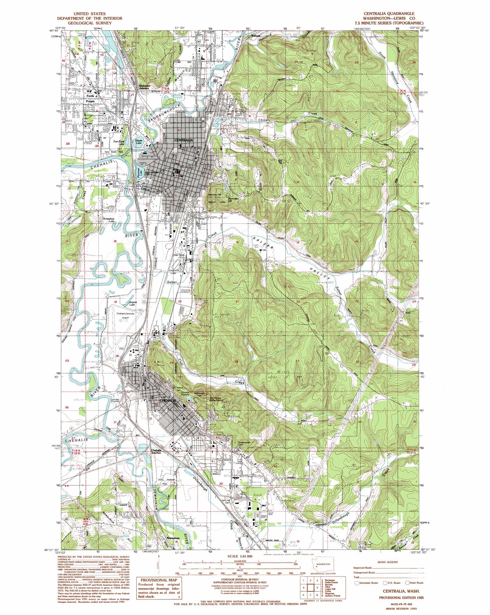
Centralia Topo Map Washington
To zoom in, hover over the map of Centralia
USGS Topo Quad 46122f8 - 1:24,000 scale
| Topo Map Name: | Centralia |
| USGS Topo Quad ID: | 46122f8 |
| Print Size: | ca. 21 1/4" wide x 27" high |
| Southeast Coordinates: | 46.625° N latitude / 122.875° W longitude |
| Map Center Coordinates: | 46.6875° N latitude / 122.9375° W longitude |
| U.S. State: | WA |
| Filename: | o46122f8.jpg |
| Download Map JPG Image: | Centralia topo map 1:24,000 scale |
| Map Type: | Topographic |
| Topo Series: | 7.5´ |
| Map Scale: | 1:24,000 |
| Source of Map Images: | United States Geological Survey (USGS) |
| Alternate Map Versions: |
Centralia NW WA 1975, updated 1978 Download PDF Buy paper map Centralia WA 1975, updated 1986 Download PDF Buy paper map Centralia WA 1985, updated 1985 Download PDF Buy paper map Centralia WA 1985, updated 1993 Download PDF Buy paper map Centralia WA 2011 Download PDF Buy paper map Centralia WA 2014 Download PDF Buy paper map |
1:24,000 Topo Quads surrounding Centralia
Capitol Peak |
Little Rock |
Maytown |
East Olympia |
Tenalquot Prarie |
Oakville |
Rochester |
Violet Prairie |
Bucoda |
Vail |
Rainbow Falls |
Adna |
Centralia |
Logan Hill |
Onalaska Nw |
Boistfort |
Curtis |
Napavine |
Jackson Prairie |
Onalaska |
Boistfort Peak |
Wildwood |
Winlock |
Toledo |
Eden Valley |
> Back to 46122e1 at 1:100,000 scale
> Back to 46122a1 at 1:250,000 scale
> Back to U.S. Topo Maps home
Centralia topo map: Gazetteer
Centralia: Airports
Chehalis-Centralia Airport elevation 55m 180′Centralia: Crossings
Borst Park Interchange elevation 56m 183′Mellen Street Interchange elevation 50m 164′
National Avenue Interchange elevation 56m 183′
State Route Six Interchange elevation 56m 183′
Thirtieth Street Interchange elevation 56m 183′
Centralia: Dams
Borst Lake Dam elevation 54m 177′Centralia: Flats
Waunch Prairie elevation 61m 200′Centralia: Lakes
Airport Lake elevation 53m 173′Hayes Lake elevation 51m 167′
Horseshoe Lake elevation 48m 157′
Plummer Lake elevation 51m 167′
Centralia: Parks
Alexander Park elevation 58m 190′Brick Wagner Park elevation 55m 180′
Fort Borst Park elevation 49m 160′
Henderson Park elevation 71m 232′
John Dobson Park elevation 133m 436′
McFadden Park elevation 167m 547′
Noble Field elevation 56m 183′
Recreation Park elevation 58m 190′
Riverside Park elevation 54m 177′
Seminary Hill Natural Area elevation 119m 390′
Stan Hedwall Park elevation 56m 183′
Centralia: Populated Places
Blakeslee Junction elevation 59m 193′Centralia elevation 57m 187′
Chehalis elevation 74m 242′
Fords Prairie elevation 54m 177′
Newaukum elevation 98m 321′
Wabash elevation 65m 213′
Centralia: Reservoirs
Fort Borst Lake elevation 51m 167′Centralia: Streams
Berwick Creek elevation 61m 200′China Creek elevation 59m 193′
Coal Creek elevation 54m 177′
Coal Creek elevation 48m 157′
Coffee Creek elevation 56m 183′
Dillenbaugh Creek elevation 50m 164′
Hanaford Creek elevation 64m 209′
Newaukum River elevation 49m 160′
Salzer Creek elevation 50m 164′
Scheuber Drainage Ditch elevation 48m 157′
Skookumchuck River elevation 47m 154′
Centralia: Summits
Ham Hill elevation 100m 328′Seminary Hill elevation 142m 465′
Centralia: Valleys
Little Hanaford Valley elevation 64m 209′Salzer Valley elevation 53m 173′
Centralia digital topo map on disk
Buy this Centralia topo map showing relief, roads, GPS coordinates and other geographical features, as a high-resolution digital map file on DVD: