Tenalquot Prarie Topo Map Washington
To zoom in, hover over the map of Tenalquot Prarie
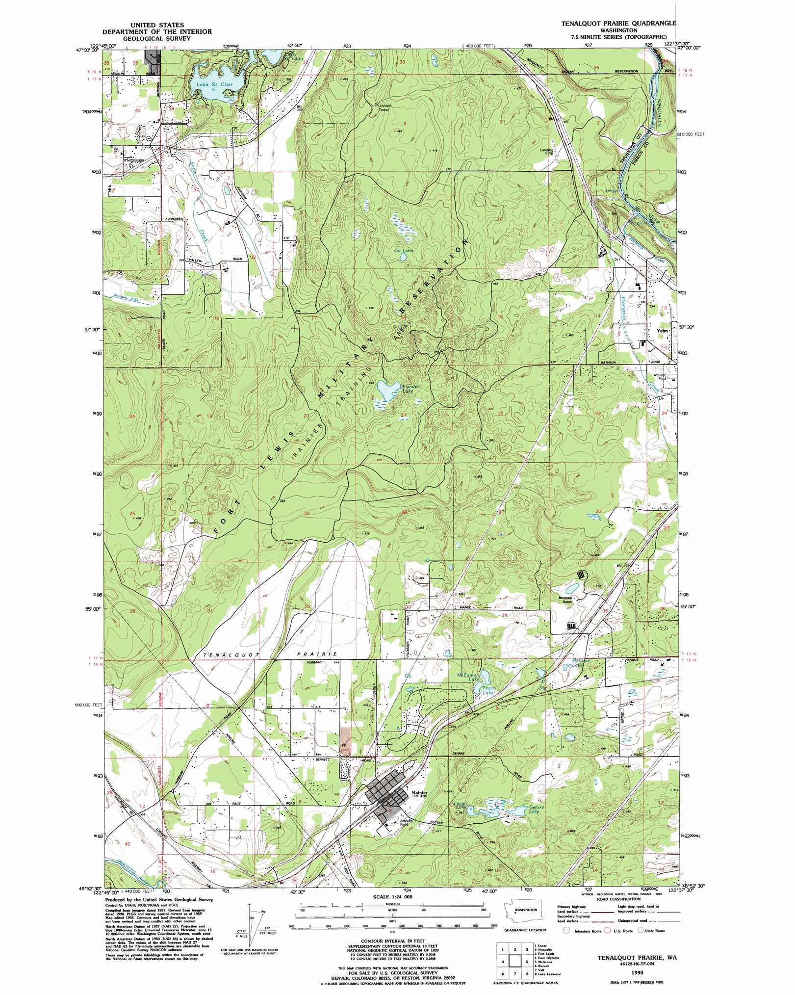
USGS Topo Quad 46122h6 - 1:24,000 scale
| Topo Map Name: | Tenalquot Prarie |
| USGS Topo Quad ID: | 46122h6 |
| Print Size: | ca. 21 1/4" wide x 27" high |
| Southeast Coordinates: | 46.875° N latitude / 122.625° W longitude |
| Map Center Coordinates: | 46.9375° N latitude / 122.6875° W longitude |
| U.S. State: | WA |
| Filename: | o46122h6.jpg |
| Download Map JPG Image: | Tenalquot Prarie topo map 1:24,000 scale |
| Map Type: | Topographic |
| Topo Series: | 7.5´ |
| Map Scale: | 1:24,000 |
| Source of Map Images: | United States Geological Survey (USGS) |
| Alternate Map Versions: |
Weir Prairie WA 1959, updated 1966 Download PDF Buy paper map Weir Prairie WA 1959, updated 1969 Download PDF Buy paper map Tenalquot Prairie WA 1959, updated 1991 Download PDF Buy paper map Tenalquot Prairie WA 1990, updated 1995 Download PDF Buy paper map Tenalquot Prairie WA 2011 Download PDF Buy paper map Tenalquot Prairie WA 2013 Download PDF Buy paper map |
1:24,000 Topo Quads surrounding Tenalquot Prarie
Squaxin Island |
Longbranch |
Mcneil Island |
Steilacoom |
Tacoma South |
Olympia |
Lacey |
Nisqually |
Fort Lewis |
Spanaway |
Maytown |
East Olympia |
Tenalquot Prarie |
Mckenna |
Harts Lake |
Violet Prairie |
Bucoda |
Vail |
Lake Lawrence |
Bald Hill |
Centralia |
Logan Hill |
Onalaska Nw |
Bernier Creek |
Newaukum Lake |
> Back to 46122e1 at 1:100,000 scale
> Back to 46122a1 at 1:250,000 scale
> Back to U.S. Topo Maps home
Tenalquot Prarie topo map: Gazetteer
Tenalquot Prarie: Dams
Oxbow Lake Dam elevation 34m 111′Tenalquot Prarie: Flats
Tenalquot Prairie elevation 147m 482′Tenalquot Prarie: Lakes
Cat Lakes elevation 139m 456′Fagan Lake elevation 128m 419′
Fiander Lake elevation 137m 449′
Gehrke Lake elevation 132m 433′
Inman Lake elevation 132m 433′
McClure Lake elevation 121m 396′
McEnniery Lake elevation 126m 413′
Tenalquot Prarie: Populated Places
Rainier elevation 132m 433′Tenalquot Prarie: Reservoirs
Oxbow Lake elevation 34m 111′Tenalquot Prarie: Streams
Eaton Creek elevation 24m 78′Thompson Creek elevation 32m 104′
Yelm Creek elevation 35m 114′
Tenalquot Prarie digital topo map on disk
Buy this Tenalquot Prarie topo map showing relief, roads, GPS coordinates and other geographical features, as a high-resolution digital map file on DVD: