East Olympia Topo Map Washington
To zoom in, hover over the map of East Olympia
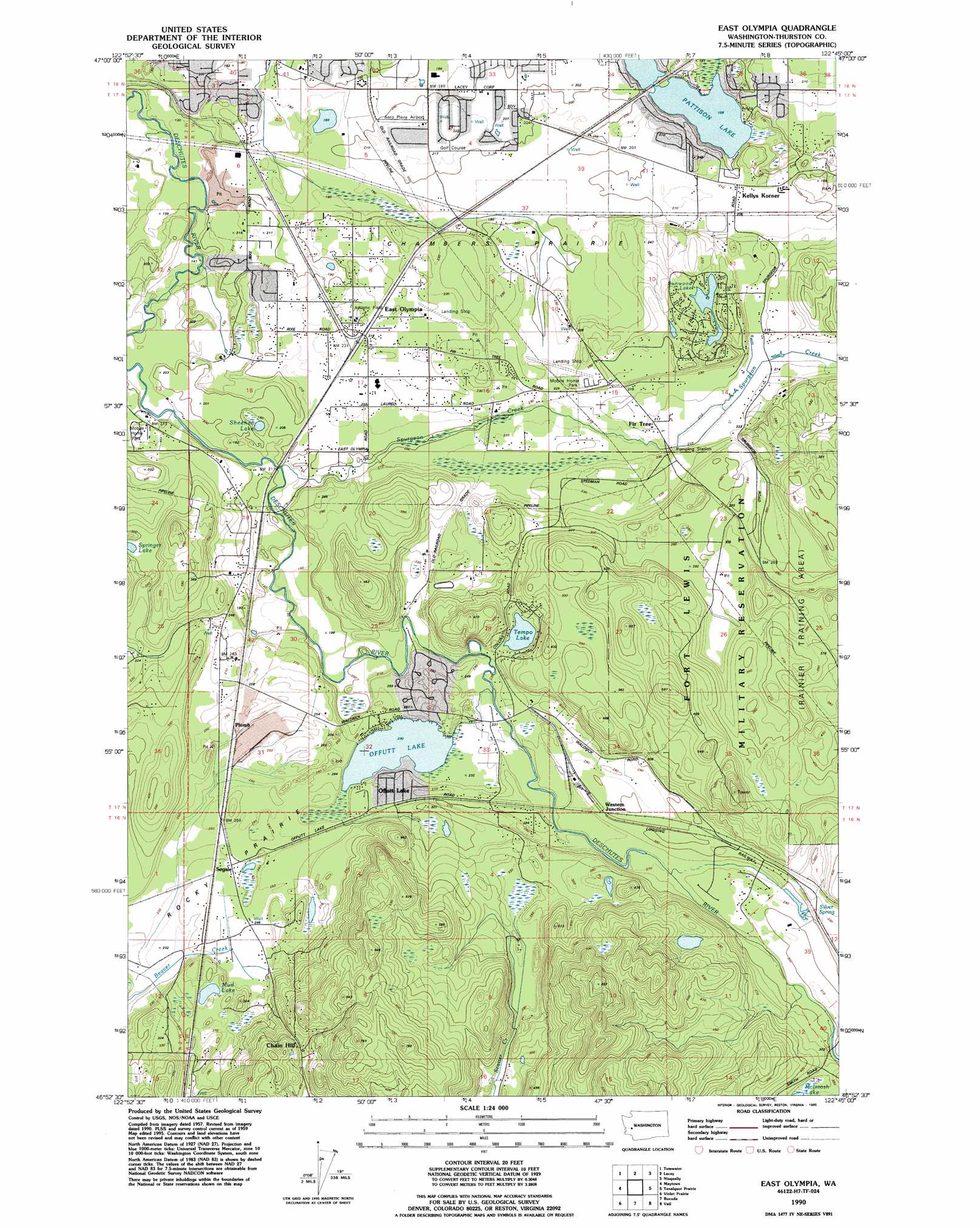
USGS Topo Quad 46122h7 - 1:24,000 scale
| Topo Map Name: | East Olympia |
| USGS Topo Quad ID: | 46122h7 |
| Print Size: | ca. 21 1/4" wide x 27" high |
| Southeast Coordinates: | 46.875° N latitude / 122.75° W longitude |
| Map Center Coordinates: | 46.9375° N latitude / 122.8125° W longitude |
| U.S. State: | WA |
| Filename: | o46122h7.jpg |
| Download Map JPG Image: | East Olympia topo map 1:24,000 scale |
| Map Type: | Topographic |
| Topo Series: | 7.5´ |
| Map Scale: | 1:24,000 |
| Source of Map Images: | United States Geological Survey (USGS) |
| Alternate Map Versions: |
East Olympia WA 1959, updated 1966 Download PDF Buy paper map East Olympia WA 1959, updated 1969 Download PDF Buy paper map East Olympia WA 1959, updated 1982 Download PDF Buy paper map East Olympia WA 1990, updated 1995 Download PDF Buy paper map East Olympia WA 2011 Download PDF Buy paper map East Olympia WA 2013 Download PDF Buy paper map |
1:24,000 Topo Quads surrounding East Olympia
Shelton |
Squaxin Island |
Longbranch |
Mcneil Island |
Steilacoom |
Summit Lake |
Olympia |
Lacey |
Nisqually |
Fort Lewis |
Little Rock |
Maytown |
East Olympia |
Tenalquot Prarie |
Mckenna |
Rochester |
Violet Prairie |
Bucoda |
Vail |
Lake Lawrence |
Adna |
Centralia |
Logan Hill |
Onalaska Nw |
Bernier Creek |
> Back to 46122e1 at 1:100,000 scale
> Back to 46122a1 at 1:250,000 scale
> Back to U.S. Topo Maps home
East Olympia topo map: Gazetteer
East Olympia: Airports
Aero Plaza Airport elevation 65m 213′Flying Carpet Airport elevation 65m 213′
Kari Field elevation 69m 226′
East Olympia: Dams
Tempo Lake Dam elevation 80m 262′East Olympia: Flats
Chambers Prairie elevation 61m 200′Rocky Prairie elevation 76m 249′
East Olympia: Lakes
Mud Lake elevation 82m 269′Offutt Lake elevation 71m 232′
Pattison Lake elevation 49m 160′
Sheehan Lake elevation 54m 177′
Sunwood Lake elevation 76m 249′
East Olympia: Populated Places
Chain Hill elevation 128m 419′East Olympia elevation 67m 219′
Fir Tree elevation 68m 223′
Kellys Korner elevation 65m 213′
Offutt Lake elevation 86m 282′
Plumb elevation 80m 262′
Skookumchuck elevation 100m 328′
Western Junction elevation 91m 298′
East Olympia: Reservoirs
Tempo Lake elevation 80m 262′East Olympia: Springs
Silver Spring elevation 95m 311′East Olympia: Streams
Spurgeon Creek elevation 62m 203′East Olympia digital topo map on disk
Buy this East Olympia topo map showing relief, roads, GPS coordinates and other geographical features, as a high-resolution digital map file on DVD: