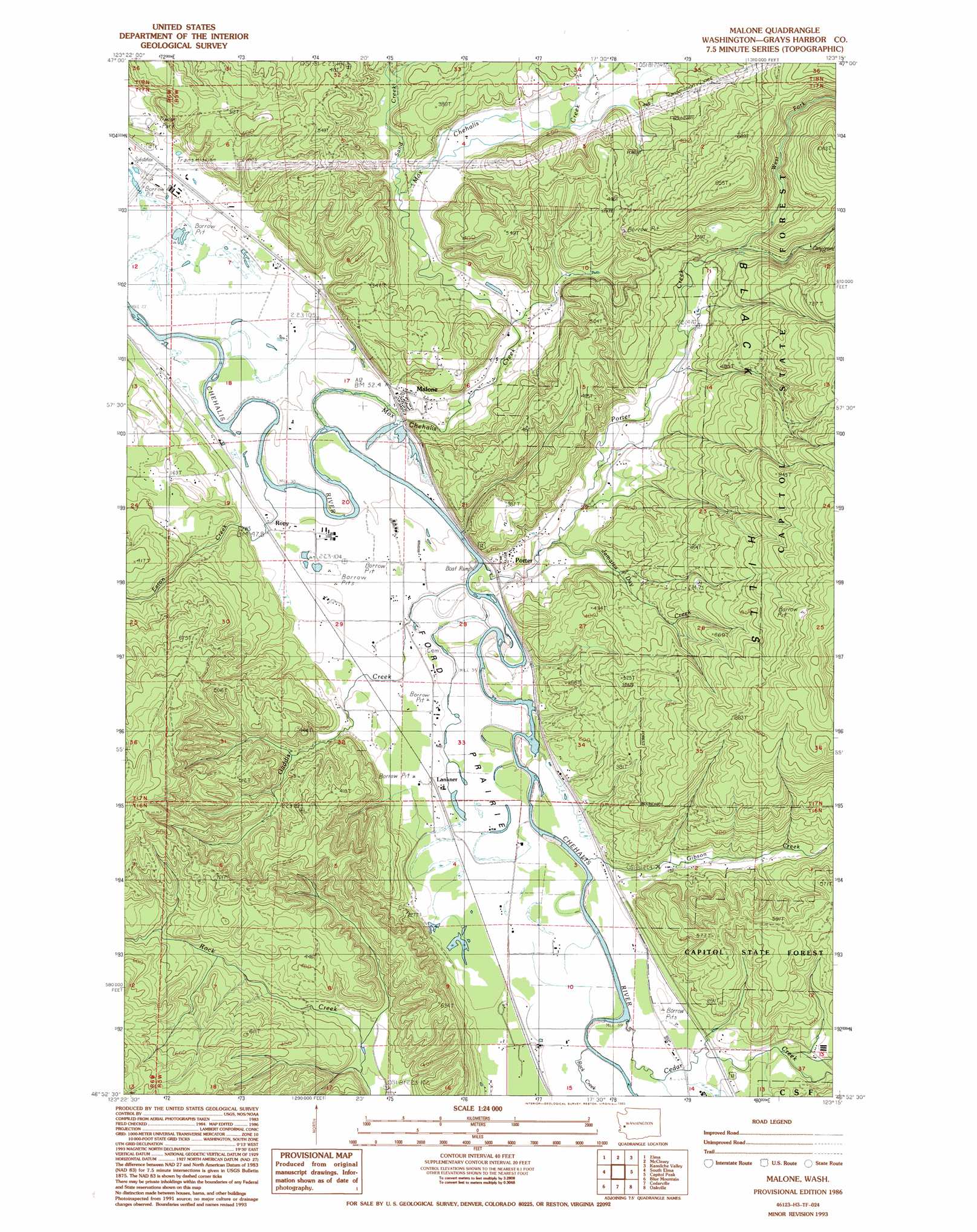
Malone Topo Map Washington
To zoom in, hover over the map of Malone
USGS Topo Quad 46123h3 - 1:24,000 scale
| Topo Map Name: | Malone |
| USGS Topo Quad ID: | 46123h3 |
| Print Size: | ca. 21 1/4" wide x 27" high |
| Southeast Coordinates: | 46.875° N latitude / 123.25° W longitude |
| Map Center Coordinates: | 46.9375° N latitude / 123.3125° W longitude |
| U.S. State: | WA |
| Filename: | o46123h3.jpg |
| Download Map JPG Image: | Malone topo map 1:24,000 scale |
| Map Type: | Topographic |
| Topo Series: | 7.5´ |
| Map Scale: | 1:24,000 |
| Source of Map Images: | United States Geological Survey (USGS) |
| Alternate Map Versions: |
Malone WA 1986, updated 1986 Download PDF Buy paper map Malone WA 1986, updated 1993 Download PDF Buy paper map Malone WA 2011 Download PDF Buy paper map Malone WA 2014 Download PDF Buy paper map |
1:24,000 Topo Quads surrounding Malone
Wynoochee Valley Ne |
Matlock |
Nahwatzel Lake |
Shelton Valley |
Shelton |
Prices Peak |
Elma |
Mccleary |
Kamilche Valley |
Summit Lake |
Montesano |
South Elma |
Malone |
Capitol Peak |
Little Rock |
Brooklyn |
Blue Mountain |
Cedarville |
Oakville |
Rochester |
East Of Raymond |
Dean Creek |
Doty |
Rainbow Falls |
Adna |
> Back to 46123e1 at 1:100,000 scale
> Back to 46122a1 at 1:250,000 scale
> Back to U.S. Topo Maps home
Malone topo map: Gazetteer
Malone: Flats
Ford Prairie elevation 18m 59′Malone: Populated Places
Greenwood elevation 14m 45′Lankner elevation 20m 65′
Malone elevation 23m 75′
Melone elevation 25m 82′
Porter elevation 20m 65′
Rony elevation 15m 49′
Malone: Streams
Cedar Creek elevation 13m 42′Eaton Creek elevation 7m 22′
Gaddis Creek elevation 13m 42′
Gibson Creek elevation 13m 42′
Jamaica Day Creek elevation 16m 52′
Mox Chehalis Creek elevation 7m 22′
Porter Creek elevation 13m 42′
Rock Creek elevation 12m 39′
Sand Creek elevation 37m 121′
Shelton Creek elevation 30m 98′
West Fork Porter Creek elevation 93m 305′
Malone: Trails
Little Spur Truck Trail elevation 278m 912′Malone digital topo map on disk
Buy this Malone topo map showing relief, roads, GPS coordinates and other geographical features, as a high-resolution digital map file on DVD: