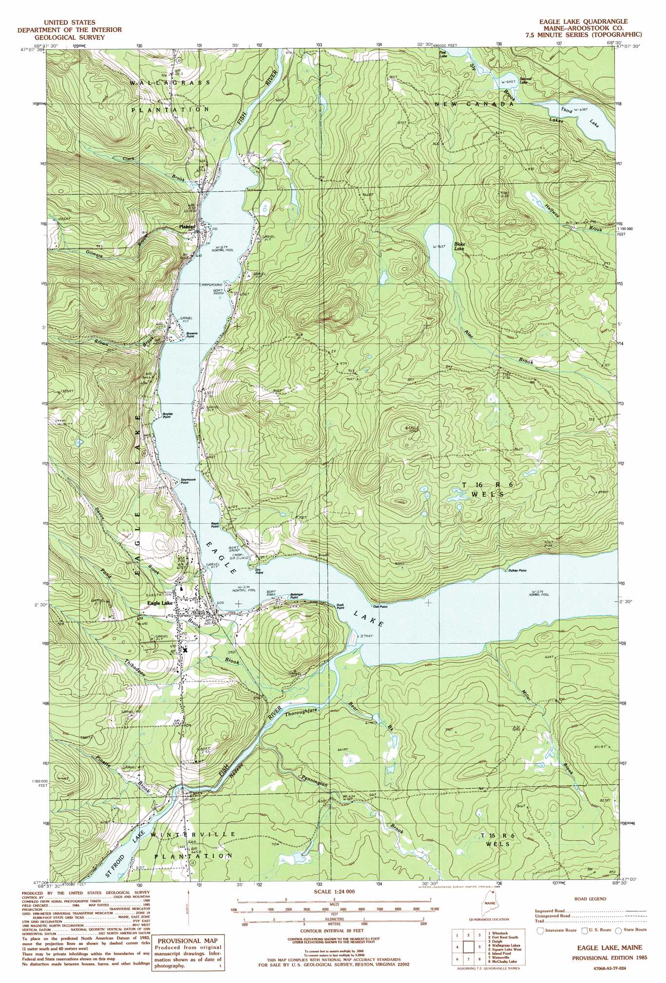
Eagle Lake Topo Map Maine
To zoom in, hover over the map of Eagle Lake
USGS Topo Quad 47068a5 - 1:24,000 scale
| Topo Map Name: | Eagle Lake |
| USGS Topo Quad ID: | 47068a5 |
| Print Size: | ca. 21 1/4" wide x 27" high |
| Southeast Coordinates: | 47° N latitude / 68.5° W longitude |
| Map Center Coordinates: | 47.0625° N latitude / 68.5625° W longitude |
| U.S. State: | ME |
| Filename: | o47068a5.jpg |
| Download Map JPG Image: | Eagle Lake topo map 1:24,000 scale |
| Map Type: | Topographic |
| Topo Series: | 7.5´ |
| Map Scale: | 1:24,000 |
| Source of Map Images: | United States Geological Survey (USGS) |
| Alternate Map Versions: |
Eagle Lake SE ME 1975, updated 1981 Download PDF Buy paper map Eagle Lake ME 1985, updated 1986 Download PDF Buy paper map Eagle Lake ME 2011 Download PDF Buy paper map Eagle Lake ME 2014 Download PDF Buy paper map |
1:24,000 Topo Quads surrounding Eagle Lake
Fort Kent North |
Frenchville |
Madawaska |
||
Saint John |
Wheelock |
Fort Kent South |
Daigle |
Saint Agatha |
Mclean Mountain |
Wallacrass Lakes |
Eagle Lake |
Square Lake West |
Square Lake East |
Deboullie Pond |
Island Pond |
Winterville |
Mcclusky Lake |
Hanford |
Fish River Lake |
Carr Pond |
Portage Lake West |
Portage Lake East |
Bull Brook |
> Back to 47068a1 at 1:100,000 scale
> Back to 47068a1 at 1:250,000 scale
> Back to U.S. Topo Maps home
Eagle Lake topo map: Gazetteer
Eagle Lake: Capes
Belanger Point elevation 175m 574′Boyles Point elevation 178m 583′
Browns Point elevation 177m 580′
Dry Point elevation 177m 580′
Dubay Point elevation 178m 583′
Duck Point elevation 188m 616′
Oak Point elevation 187m 613′
Roys Point elevation 175m 574′
Seymours Point elevation 183m 600′
Eagle Lake: Channels
Nadeau Thoroughfare elevation 184m 603′Eagle Lake: Lakes
Blake Lake elevation 232m 761′Eagle Lake elevation 175m 574′
Second Lake elevation 196m 643′
Sly Brook Lakes elevation 194m 636′
Third Lake elevation 194m 636′
Eagle Lake: Populated Places
Eagle Lake elevation 189m 620′Plaisted elevation 180m 590′
Eagle Lake: Post Offices
Eagle Lake Post Office elevation 244m 800′Plaisted Post Office elevation 175m 574′
Eagle Lake: Streams
Bear Brook elevation 176m 577′Brown Brook elevation 177m 580′
Clark Brook elevation 176m 577′
Devoe Brook elevation 177m 580′
Gilmore Brook elevation 175m 574′
Miller Brook elevation 175m 574′
Pennington Brook elevation 176m 577′
Pinette Brook elevation 181m 593′
Pond Brook elevation 175m 574′
Thibadeau Brook elevation 180m 590′
Eagle Lake digital topo map on disk
Buy this Eagle Lake topo map showing relief, roads, GPS coordinates and other geographical features, as a high-resolution digital map file on DVD:
Maine, New Hampshire, Rhode Island & Eastern Massachusetts
Buy digital topo maps: Maine, New Hampshire, Rhode Island & Eastern Massachusetts