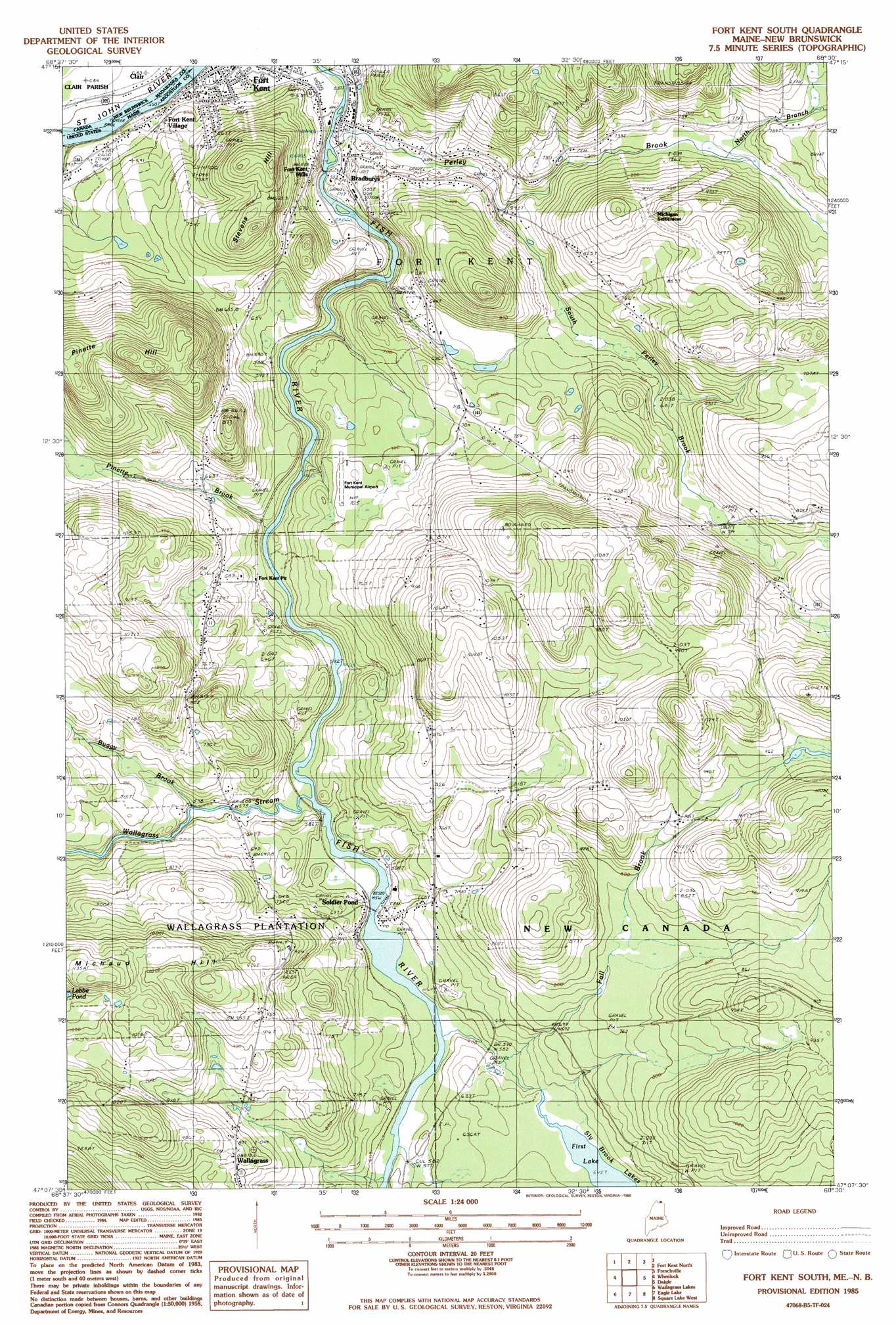
Fort Kent South Topo Map Maine
To zoom in, hover over the map of Fort Kent South
USGS Topo Quad 47068b5 - 1:24,000 scale
| Topo Map Name: | Fort Kent South |
| USGS Topo Quad ID: | 47068b5 |
| Print Size: | ca. 21 1/4" wide x 27" high |
| Southeast Coordinates: | 47.125° N latitude / 68.5° W longitude |
| Map Center Coordinates: | 47.1875° N latitude / 68.5625° W longitude |
| U.S. State: | ME |
| Filename: | o47068b5.jpg |
| Download Map JPG Image: | Fort Kent South topo map 1:24,000 scale |
| Map Type: | Topographic |
| Topo Series: | 7.5´ |
| Map Scale: | 1:24,000 |
| Source of Map Images: | United States Geological Survey (USGS) |
| Alternate Map Versions: |
Eagle Lake NE ME 1975, updated 1981 Download PDF Buy paper map Fort Kent South ME 1985, updated 1986 Download PDF Buy paper map Fort Kent South ME 2011 Download PDF Buy paper map Fort Kent South ME 2014 Download PDF Buy paper map |
1:24,000 Topo Quads surrounding Fort Kent South
Fort Kent North |
Frenchville |
Madawaska |
||
Saint John |
Wheelock |
Fort Kent South |
Daigle |
Saint Agatha |
Mclean Mountain |
Wallacrass Lakes |
Eagle Lake |
Square Lake West |
Square Lake East |
Deboullie Pond |
Island Pond |
Winterville |
Mcclusky Lake |
Hanford |
> Back to 47068a1 at 1:100,000 scale
> Back to 47068a1 at 1:250,000 scale
> Back to U.S. Topo Maps home
Fort Kent South topo map: Gazetteer
Fort Kent South: Airports
Fort Kent Municipal Airport elevation 215m 705′Fort Kent South: Bridges
International Bridge elevation 149m 488′Fort Kent South: Falls
Fish River Falls elevation 175m 574′Fort Kent South: Lakes
First Lake elevation 196m 643′Fort Kent South: Populated Places
Bradburys elevation 169m 554′Fort Kent Mills elevation 190m 623′
Fort Kent Village elevation 163m 534′
Michigan Settlement elevation 281m 921′
Plourde Mill elevation 203m 666′
Soldier Pond elevation 185m 606′
Wallagrass elevation 267m 875′
Fort Kent South: Post Offices
Fort Kent Post Office (historical) elevation 158m 518′Soldier Pond Post Office elevation 173m 567′
Fort Kent South: Streams
Buggy Brook elevation 180m 590′Fall Brook elevation 173m 567′
North Branch Perley Brook elevation 218m 715′
Perley Brook elevation 156m 511′
Pinette Brook elevation 174m 570′
South Perley Brook elevation 175m 574′
Wallagrass Stream elevation 171m 561′
Fort Kent South: Summits
Michaud Hill elevation 356m 1167′Pinette Hill elevation 381m 1250′
Stevens Hill elevation 298m 977′
Fort Kent South digital topo map on disk
Buy this Fort Kent South topo map showing relief, roads, GPS coordinates and other geographical features, as a high-resolution digital map file on DVD:
Maine, New Hampshire, Rhode Island & Eastern Massachusetts
Buy digital topo maps: Maine, New Hampshire, Rhode Island & Eastern Massachusetts