Lake Medora Topo Map Michigan
To zoom in, hover over the map of Lake Medora
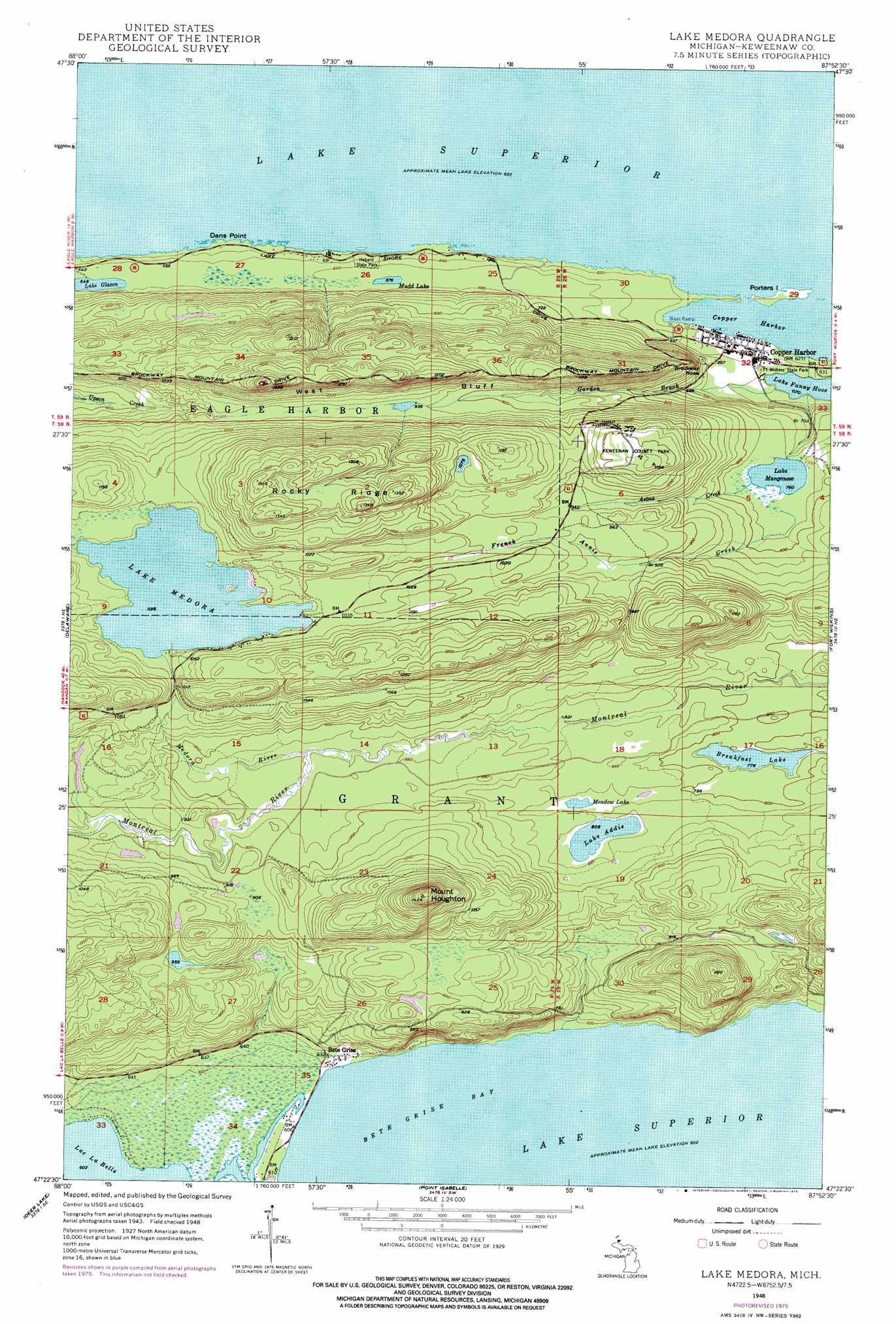
USGS Topo Quad 47087d8 - 1:24,000 scale
| Topo Map Name: | Lake Medora |
| USGS Topo Quad ID: | 47087d8 |
| Print Size: | ca. 21 1/4" wide x 27" high |
| Southeast Coordinates: | 47.375° N latitude / 87.875° W longitude |
| Map Center Coordinates: | 47.4375° N latitude / 87.9375° W longitude |
| U.S. State: | MI |
| Filename: | o47087d8.jpg |
| Download Map JPG Image: | Lake Medora topo map 1:24,000 scale |
| Map Type: | Topographic |
| Topo Series: | 7.5´ |
| Map Scale: | 1:24,000 |
| Source of Map Images: | United States Geological Survey (USGS) |
| Alternate Map Versions: |
Lake Medora MI 1948, updated 1964 Download PDF Buy paper map Lake Medora MI 1948, updated 1976 Download PDF Buy paper map Lake Medora MI 1949, updated 1949 Download PDF Buy paper map Lake Medora MI 2011 Download PDF Buy paper map Lake Medora MI 2014 Download PDF Buy paper map Lake Medora MI 2017 Download PDF Buy paper map |
1:24,000 Topo Quads surrounding Lake Medora
Eagle Harbor |
Delaware |
Lake Medora |
Fort Wilkins |
Manitou Island |
Bruneau Creek |
Deer Lake |
Point Isabelle |
||
Gay |
> Back to 47087a1 at 1:100,000 scale
> Back to 47086a1 at 1:250,000 scale
> Back to U.S. Topo Maps home
Lake Medora topo map: Gazetteer
Lake Medora: Capes
Dans Point elevation 184m 603′Lake Medora: Cliffs
West Bluff elevation 360m 1181′Lake Medora: Falls
Manganese Falls elevation 214m 702′Lake Medora: Islands
Porters Island elevation 189m 620′Lake Medora: Lakes
Breakfast Lake elevation 233m 764′Lake Addie elevation 246m 807′
Lake Manganese elevation 232m 761′
Lake Medora elevation 306m 1003′
Meadow Lake elevation 246m 807′
Mudd Lake elevation 203m 666′
Lake Medora: Parks
Hebard Park elevation 196m 643′Keweenaw County Park elevation 341m 1118′
Lake Medora: Populated Places
Bete Grise elevation 190m 623′Copper Harbor elevation 188m 616′
Lake Medora: Post Offices
Copper Harbor Post Office elevation 191m 626′Lake Medora: Ridges
Rocky Ridge elevation 382m 1253′Lake Medora: Streams
Aetna Creek elevation 236m 774′French Annie Creek elevation 236m 774′
Garden Brook elevation 190m 623′
Medora River elevation 262m 859′
Lake Medora: Summits
Brockway Nose elevation 272m 892′Mount Houghton elevation 444m 1456′
Lake Medora digital topo map on disk
Buy this Lake Medora topo map showing relief, roads, GPS coordinates and other geographical features, as a high-resolution digital map file on DVD: