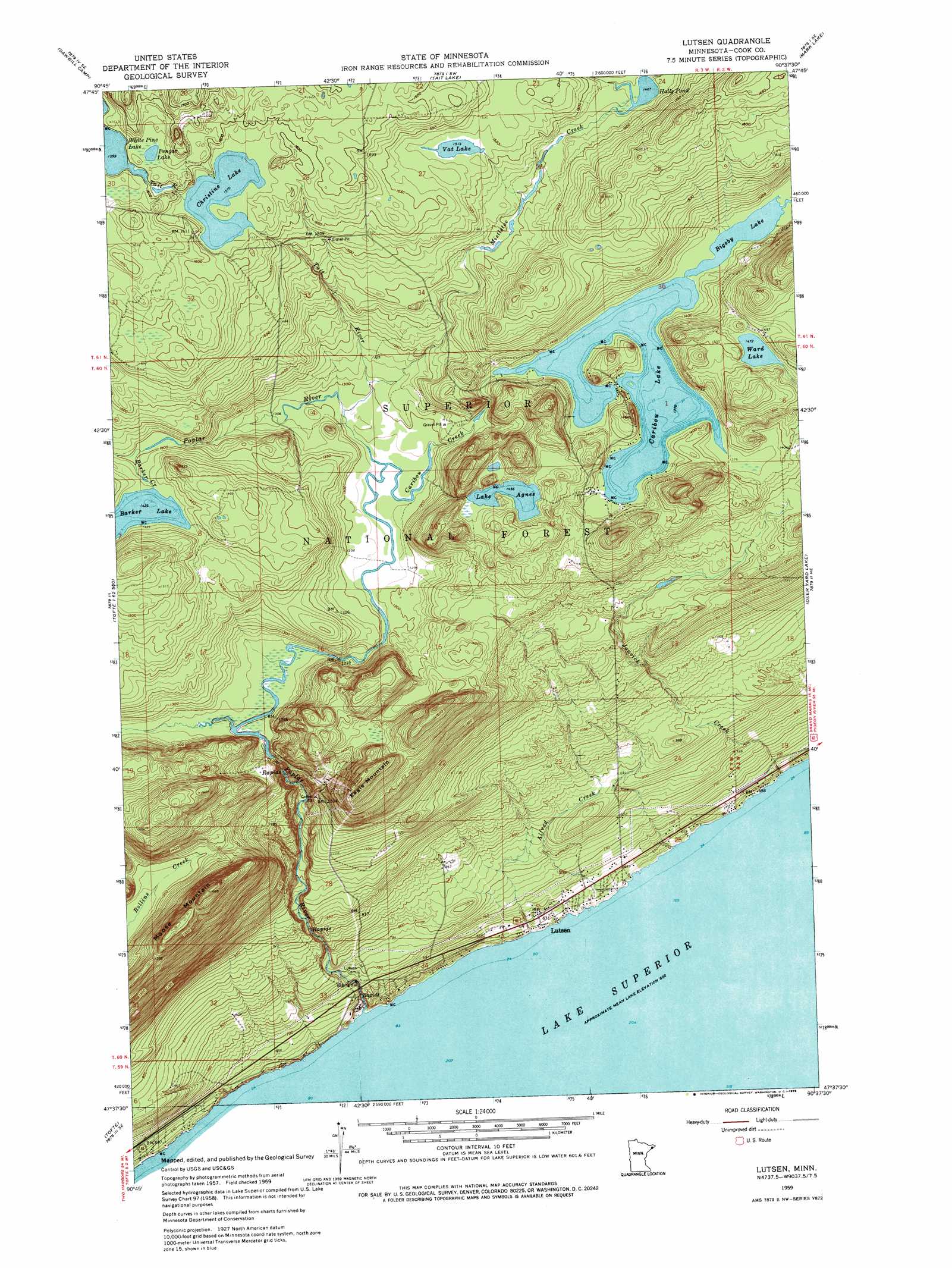
Lutsen Topo Map Minnesota
To zoom in, hover over the map of Lutsen
USGS Topo Quad 47090f6 - 1:24,000 scale
| Topo Map Name: | Lutsen |
| USGS Topo Quad ID: | 47090f6 |
| Print Size: | ca. 21 1/4" wide x 27" high |
| Southeast Coordinates: | 47.625° N latitude / 90.625° W longitude |
| Map Center Coordinates: | 47.6875° N latitude / 90.6875° W longitude |
| U.S. State: | MN |
| Filename: | o47090f6.jpg |
| Download Map JPG Image: | Lutsen topo map 1:24,000 scale |
| Map Type: | Topographic |
| Topo Series: | 7.5´ |
| Map Scale: | 1:24,000 |
| Source of Map Images: | United States Geological Survey (USGS) |
| Alternate Map Versions: |
Lutsen MN 1959, updated 1960 Download PDF Buy paper map Lutsen MN 1959, updated 1962 Download PDF Buy paper map Lutsen MN 1959, updated 1972 Download PDF Buy paper map Lutsen MN 1959, updated 1972 Download PDF Buy paper map Lutsen MN 2011 Download PDF Buy paper map Lutsen MN 2013 Download PDF Buy paper map Lutsen MN 2016 Download PDF Buy paper map |
| FStopo: | US Forest Service topo Lutsen is available: Download FStopo PDF Download FStopo TIF |
1:24,000 Topo Quads surrounding Lutsen
Kelso Mountain |
Cherokee Lake |
Brule Lake |
Eagle Mountain |
Lima Mountain |
Beth Lake |
Sawbill Camp |
Tait Lake |
Mark Lake |
Devil Track Lake |
Toohey Lake |
Honeymoon Mountain |
Lutsen |
Deer Yard Lake |
|
Schroeder |
Tofte |
|||
Little Marais |
> Back to 47090e1 at 1:100,000 scale
> Back to 47090a1 at 1:250,000 scale
> Back to U.S. Topo Maps home
Lutsen topo map: Gazetteer
Lutsen: Lakes
Barker Lake elevation 434m 1423′Bigsby Lake elevation 418m 1371′
Caribou Lake elevation 418m 1371′
Christine Lake elevation 479m 1571′
Halls Pond elevation 447m 1466′
Lake Agnes elevation 444m 1456′
Pengar Lake elevation 489m 1604′
Vat Lake elevation 462m 1515′
Ward Lake elevation 449m 1473′
Lutsen: Populated Places
Lutsen elevation 204m 669′Lutsen Mobile Home Park elevation 198m 649′
Lutsen: Post Offices
Lutsen Post Office elevation 205m 672′Lutsen: Streams
Alfred Creek elevation 184m 603′Barker Creek elevation 426m 1397′
Caribou Creek elevation 393m 1289′
Jonvick Creek elevation 184m 603′
Mistletoe Creek elevation 397m 1302′
Murmur Creek elevation 418m 1371′
Poplar River elevation 184m 603′
Tait River elevation 393m 1289′
Lutsen: Summits
Eagle Mountain elevation 505m 1656′Moose Mountain elevation 513m 1683′
Lutsen digital topo map on disk
Buy this Lutsen topo map showing relief, roads, GPS coordinates and other geographical features, as a high-resolution digital map file on DVD: