Doyle Lake Topo Map Minnesota
To zoom in, hover over the map of Doyle Lake
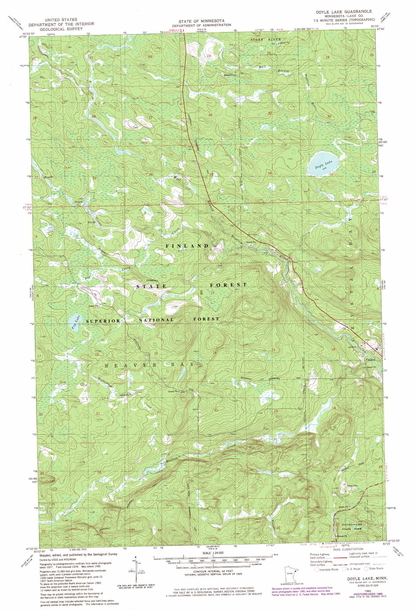
USGS Topo Quad 47091d3 - 1:24,000 scale
| Topo Map Name: | Doyle Lake |
| USGS Topo Quad ID: | 47091d3 |
| Print Size: | ca. 21 1/4" wide x 27" high |
| Southeast Coordinates: | 47.375° N latitude / 91.25° W longitude |
| Map Center Coordinates: | 47.4375° N latitude / 91.3125° W longitude |
| U.S. State: | MN |
| Filename: | o47091d3.jpg |
| Download Map JPG Image: | Doyle Lake topo map 1:24,000 scale |
| Map Type: | Topographic |
| Topo Series: | 7.5´ |
| Map Scale: | 1:24,000 |
| Source of Map Images: | United States Geological Survey (USGS) |
| Alternate Map Versions: |
Doyle Lake MN 1982, updated 1983 Download PDF Buy paper map Doyle Lake MN 1982, updated 1985 Download PDF Buy paper map Doyle Lake MN 2011 Download PDF Buy paper map Doyle Lake MN 2013 Download PDF Buy paper map Doyle Lake MN 2016 Download PDF Buy paper map |
| FStopo: | US Forest Service topo Doyle Lake is available: Download FStopo PDF Download FStopo TIF |
1:24,000 Topo Quads surrounding Doyle Lake
Slate Lake East |
Mitawan Lake |
Sawbill Landing |
Silver Island Lake |
Wilson Lake |
Greenwood Lake East |
Isabella Station |
Isabella |
Cabin Lake |
Cramer |
Whyte |
Cloquet Lake |
Doyle Lake |
Finland |
|
Legler Lake |
Silver Bay Sw |
Silver Bay |
Illgen City |
|
Two Harbors Ne |
Split Rock Point |
Split Rock Point Ne |
> Back to 47091a1 at 1:100,000 scale
> Back to 47090a1 at 1:250,000 scale
> Back to U.S. Topo Maps home
Doyle Lake topo map: Gazetteer
Doyle Lake: Lakes
Doyle Lake elevation 512m 1679′Fry Lake elevation 532m 1745′
Doyle Lake: Streams
Crown Creek elevation 462m 1515′Fry Creek elevation 502m 1646′
Heffelfinger Creek elevation 472m 1548′
Hockamin Creek elevation 506m 1660′
Doyle Lake: Trails
Moosewalk Snowmobile Trail elevation 478m 1568′Doyle Lake digital topo map on disk
Buy this Doyle Lake topo map showing relief, roads, GPS coordinates and other geographical features, as a high-resolution digital map file on DVD: