Wilson Lake Topo Map Minnesota
To zoom in, hover over the map of Wilson Lake
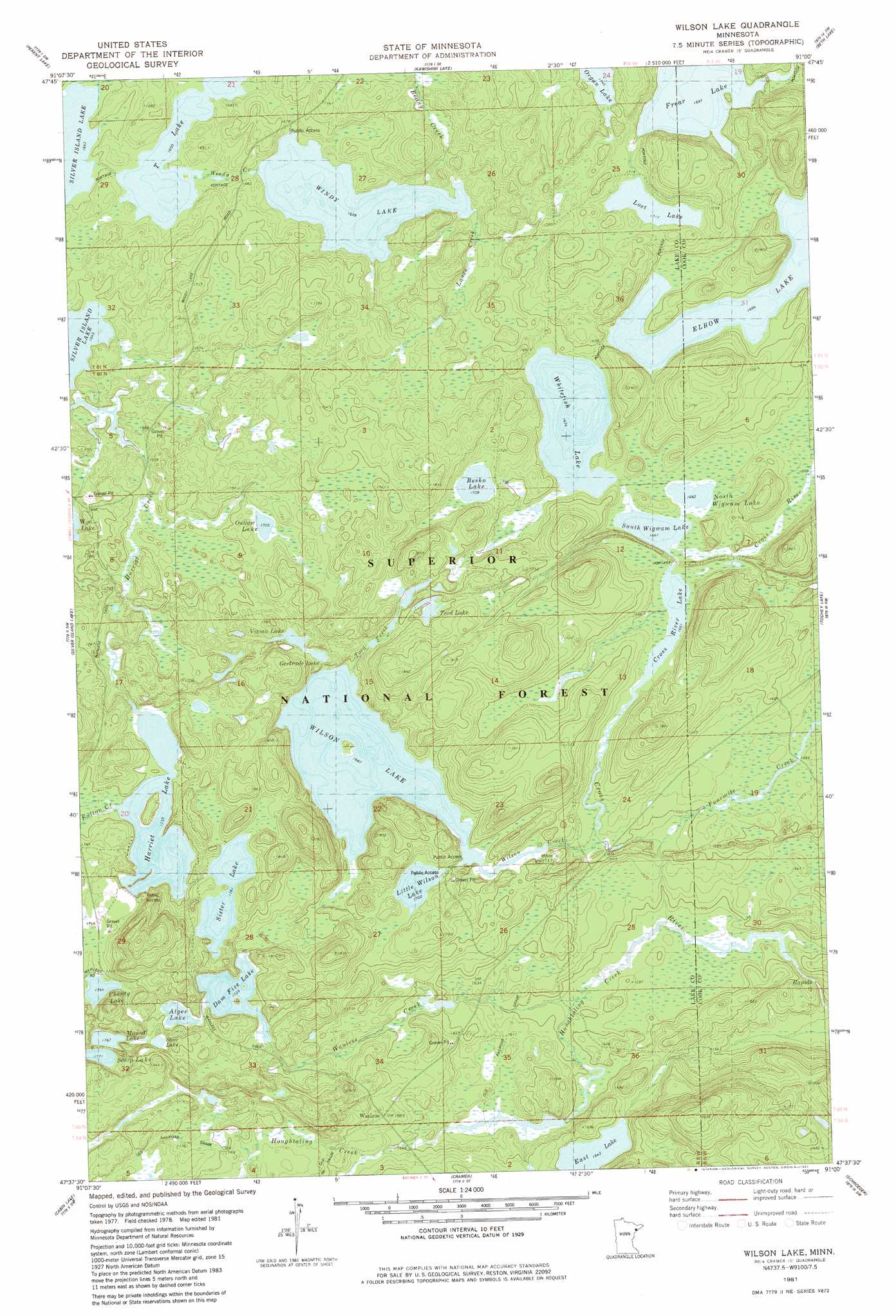
USGS Topo Quad 47091f1 - 1:24,000 scale
| Topo Map Name: | Wilson Lake |
| USGS Topo Quad ID: | 47091f1 |
| Print Size: | ca. 21 1/4" wide x 27" high |
| Southeast Coordinates: | 47.625° N latitude / 91° W longitude |
| Map Center Coordinates: | 47.6875° N latitude / 91.0625° W longitude |
| U.S. State: | MN |
| Filename: | o47091f1.jpg |
| Download Map JPG Image: | Wilson Lake topo map 1:24,000 scale |
| Map Type: | Topographic |
| Topo Series: | 7.5´ |
| Map Scale: | 1:24,000 |
| Source of Map Images: | United States Geological Survey (USGS) |
| Alternate Map Versions: |
Wilson Lake MN 1981, updated 1982 Download PDF Buy paper map Wilson Lake MN 1981, updated 1985 Download PDF Buy paper map Wilson Lake MN 2011 Download PDF Buy paper map Wilson Lake MN 2013 Download PDF Buy paper map Wilson Lake MN 2016 Download PDF Buy paper map |
| FStopo: | US Forest Service topo Wilson Lake is available: Download FStopo PDF Download FStopo TIF |
1:24,000 Topo Quads surrounding Wilson Lake
Lake Insula |
Alice Lake |
Lake Polly |
Kelso Mountain |
Cherokee Lake |
Isabella Lake |
Perent Lake |
Kawishiwi Lake |
Beth Lake |
Sawbill Camp |
Sawbill Landing |
Silver Island Lake |
Wilson Lake |
Toohey Lake |
Honeymoon Mountain |
Isabella |
Cabin Lake |
Cramer |
Schroeder |
Tofte |
Doyle Lake |
Finland |
Little Marais |
> Back to 47091e1 at 1:100,000 scale
> Back to 47090a1 at 1:250,000 scale
> Back to U.S. Topo Maps home
Wilson Lake topo map: Gazetteer
Wilson Lake: Dams
Cross River Number Three Dam elevation 538m 1765′Dam Five Lake Dam elevation 528m 1732′
Wilson Lake Dam elevation 519m 1702′
Wilson Lake: Lakes
Alger Lake elevation 532m 1745′Besho Lake elevation 520m 1706′
Charity Lake elevation 538m 1765′
Cross River Lake elevation 506m 1660′
Dam Five Lake elevation 530m 1738′
East Lake elevation 501m 1643′
Elbow Lake elevation 514m 1686′
Frear Lake elevation 517m 1696′
Gertrude Lake elevation 520m 1706′
Harriet Lake elevation 530m 1738′
Little Wilson Lake elevation 519m 1702′
Lost Lake elevation 523m 1715′
Mound Lake elevation 539m 1768′
Organ Lake elevation 532m 1745′
Outlaw Lake elevation 521m 1709′
Sister Lake elevation 537m 1761′
South Wigwam Lake elevation 506m 1660′
Steer Lake elevation 538m 1765′
T Lake elevation 503m 1650′
Tord Lake elevation 534m 1751′
Vivian Lake elevation 521m 1709′
Whitefish Lake elevation 510m 1673′
Wigwam Lake elevation 509m 1669′
Wilson Lake elevation 514m 1686′
Windy Lake elevation 506m 1660′
Wilson Lake: Reservoirs
Dam Five Lake elevation 528m 1732′Wigwam Lake elevation 538m 1765′
Wilson Lake elevation 519m 1702′
Wilson Lake: Streams
Beany Creek elevation 506m 1660′Fourmile Creek elevation 497m 1630′
Fulton Creek elevation 531m 1742′
Harry Creek elevation 511m 1676′
Houghtaling Creek elevation 482m 1581′
Landa Creek elevation 506m 1660′
Tord Creek elevation 514m 1686′
Wanless Creek elevation 483m 1584′
Wilson Creek elevation 504m 1653′
Wilson Lake digital topo map on disk
Buy this Wilson Lake topo map showing relief, roads, GPS coordinates and other geographical features, as a high-resolution digital map file on DVD: