Sawbill Landing Topo Map Minnesota
To zoom in, hover over the map of Sawbill Landing
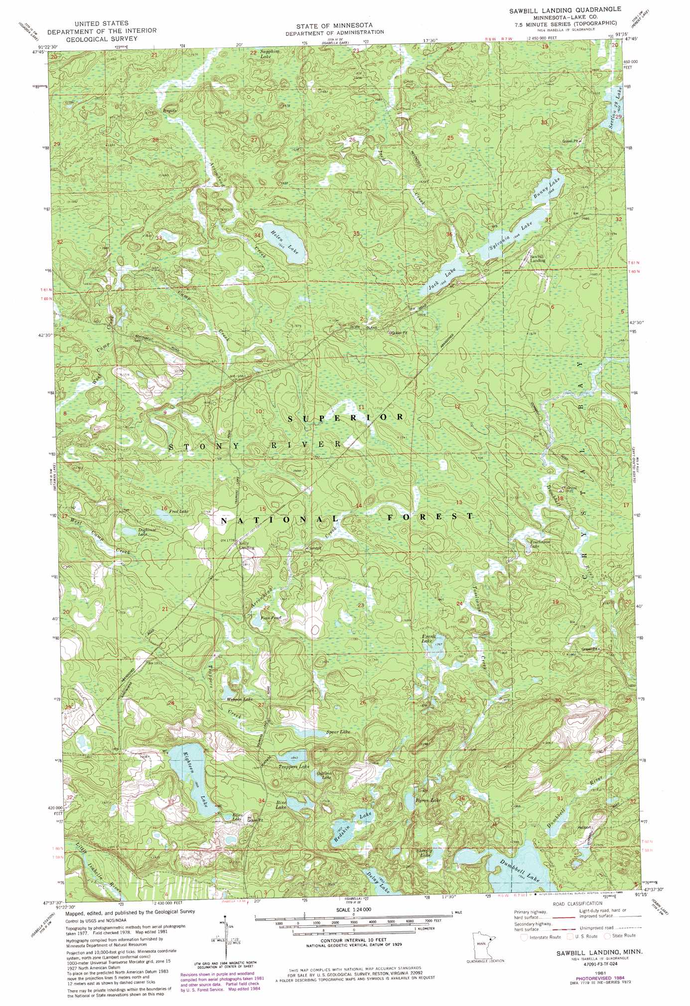
USGS Topo Quad 47091f3 - 1:24,000 scale
| Topo Map Name: | Sawbill Landing |
| USGS Topo Quad ID: | 47091f3 |
| Print Size: | ca. 21 1/4" wide x 27" high |
| Southeast Coordinates: | 47.625° N latitude / 91.25° W longitude |
| Map Center Coordinates: | 47.6875° N latitude / 91.3125° W longitude |
| U.S. State: | MN |
| Filename: | o47091f3.jpg |
| Download Map JPG Image: | Sawbill Landing topo map 1:24,000 scale |
| Map Type: | Topographic |
| Topo Series: | 7.5´ |
| Map Scale: | 1:24,000 |
| Source of Map Images: | United States Geological Survey (USGS) |
| Alternate Map Versions: |
Sawbill Landing MN 1981, updated 1983 Download PDF Buy paper map Sawbill Landing MN 1981, updated 1985 Download PDF Buy paper map Sawbill Landing MN 2011 Download PDF Buy paper map Sawbill Landing MN 2013 Download PDF Buy paper map Sawbill Landing MN 2016 Download PDF Buy paper map |
| FStopo: | US Forest Service topo Sawbill Landing is available: Download FStopo PDF Download FStopo TIF |
1:24,000 Topo Quads surrounding Sawbill Landing
Ojibway Lake |
Snowbank Lake |
Lake Insula |
Alice Lake |
Lake Polly |
Gabbro Lake |
Quadga Lake |
Isabella Lake |
Perent Lake |
Kawishiwi Lake |
Slate Lake East |
Mitawan Lake |
Sawbill Landing |
Silver Island Lake |
Wilson Lake |
Greenwood Lake East |
Isabella Station |
Isabella |
Cabin Lake |
Cramer |
Whyte |
Cloquet Lake |
Doyle Lake |
Finland |
> Back to 47091e1 at 1:100,000 scale
> Back to 47090a1 at 1:250,000 scale
> Back to U.S. Topo Maps home
Sawbill Landing topo map: Gazetteer
Sawbill Landing: Lakes
Bine Lake elevation 577m 1893′Bunny Lake elevation 502m 1646′
Byron Lake elevation 581m 1906′
Doghouse Lake elevation 533m 1748′
Eighteen Lake elevation 576m 1889′
Ellen Lake elevation 578m 1896′
Finn Pond elevation 532m 1745′
Frank Lake elevation 539m 1768′
Fred Lake elevation 530m 1738′
Helen Lake elevation 502m 1646′
Jack Lake elevation 502m 1646′
Odeima Lake elevation 567m 1860′
Redskin Lake elevation 581m 1906′
Shoofly Lake elevation 599m 1965′
Spear Lake elevation 553m 1814′
Sylvania Lake elevation 507m 1663′
Tomlinson Lake elevation 516m 1692′
Trappers Lake elevation 562m 1843′
Weapon Lake elevation 545m 1788′
Sawbill Landing: Populated Places
Kelly Landing elevation 545m 1788′Martin Landing elevation 490m 1607′
Sawbill Landing elevation 516m 1692′
Wheeler Landing elevation 501m 1643′
Sawbill Landing: Post Offices
Sawbill Landing Post Office (historical) elevation 516m 1692′Sawbill Landing: Streams
Camp Creek elevation 496m 1627′Tomlinson Creek elevation 515m 1689′
Trappers Creek elevation 536m 1758′
West Camp Creek elevation 501m 1643′
Sawbill Landing digital topo map on disk
Buy this Sawbill Landing topo map showing relief, roads, GPS coordinates and other geographical features, as a high-resolution digital map file on DVD: