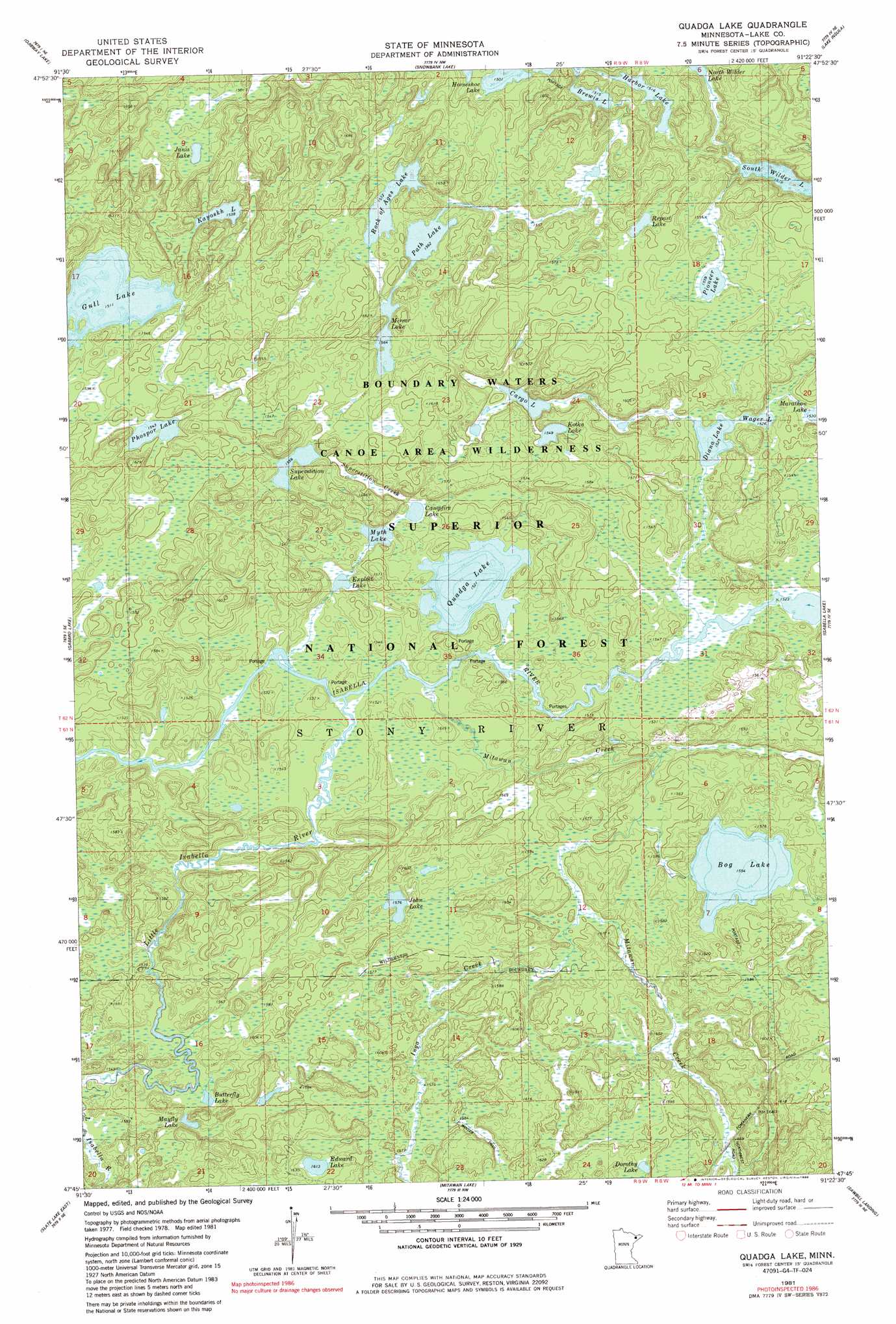
Quadga Lake Topo Map Minnesota
To zoom in, hover over the map of Quadga Lake
USGS Topo Quad 47091g4 - 1:24,000 scale
| Topo Map Name: | Quadga Lake |
| USGS Topo Quad ID: | 47091g4 |
| Print Size: | ca. 21 1/4" wide x 27" high |
| Southeast Coordinates: | 47.75° N latitude / 91.375° W longitude |
| Map Center Coordinates: | 47.8125° N latitude / 91.4375° W longitude |
| U.S. State: | MN |
| Filename: | o47091g4.jpg |
| Download Map JPG Image: | Quadga Lake topo map 1:24,000 scale |
| Map Type: | Topographic |
| Topo Series: | 7.5´ |
| Map Scale: | 1:24,000 |
| Source of Map Images: | United States Geological Survey (USGS) |
| Alternate Map Versions: |
Quadga Lake MN 1981, updated 1982 Download PDF Buy paper map Quadga Lake MN 1981, updated 1986 Download PDF Buy paper map Quadga Lake MN 2011 Download PDF Buy paper map Quadga Lake MN 2013 Download PDF Buy paper map Quadga Lake MN 2016 Download PDF Buy paper map |
| FStopo: | US Forest Service topo Quadga Lake is available: Download FStopo PDF Download FStopo TIF |
1:24,000 Topo Quads surrounding Quadga Lake
Basswood Lake West |
Basswood Lake East |
Ensign Lake West |
Ensign Lake East |
Kekekabic Lake |
Farm Lake |
Ojibway Lake |
Snowbank Lake |
Lake Insula |
Alice Lake |
Bogberry Lake |
Gabbro Lake |
Quadga Lake |
Isabella Lake |
Perent Lake |
Slate Lake West |
Slate Lake East |
Mitawan Lake |
Sawbill Landing |
Silver Island Lake |
Greenwood Lake West |
Greenwood Lake East |
Isabella Station |
Isabella |
Cabin Lake |
> Back to 47091e1 at 1:100,000 scale
> Back to 47090a1 at 1:250,000 scale
> Back to U.S. Topo Maps home
Quadga Lake topo map: Gazetteer
Quadga Lake: Lakes
Bog Lake elevation 474m 1555′Brewis Lake elevation 462m 1515′
Butterfly Lake elevation 494m 1620′
Campfire Lake elevation 465m 1525′
Cargo Lake elevation 469m 1538′
Diana Lake elevation 465m 1525′
Dorothy Lake elevation 496m 1627′
Edward Lake elevation 492m 1614′
Exploit Lake elevation 462m 1515′
Gull Lake elevation 461m 1512′
Harbor Lake elevation 462m 1515′
Janis Lake elevation 459m 1505′
John Lake elevation 481m 1578′
Kayoskh Lake elevation 469m 1538′
Kutka Lake elevation 472m 1548′
Mayfly Lake elevation 474m 1555′
Mirror Lake elevation 477m 1564′
Myth Lake elevation 465m 1525′
Path Lake elevation 476m 1561′
Phospor Lake elevation 471m 1545′
Pioneer Lake elevation 475m 1558′
Quadga Lake elevation 464m 1522′
Repast Lake elevation 480m 1574′
Rock of Ages Lake elevation 479m 1571′
South Wilder Lake elevation 487m 1597′
Superstition Lake elevation 475m 1558′
Wagner Lake elevation 465m 1525′
Quadga Lake: Streams
Inga Creek elevation 471m 1545′Jack Pine Creek elevation 479m 1571′
Little Isabella River elevation 460m 1509′
Mitawan Creek elevation 460m 1509′
Superstition Creek elevation 465m 1525′
Quadga Lake digital topo map on disk
Buy this Quadga Lake topo map showing relief, roads, GPS coordinates and other geographical features, as a high-resolution digital map file on DVD: