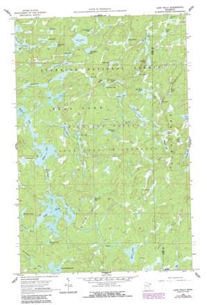
Lake Polly Topo Map Minnesota
To zoom in, hover over the map of Lake Polly
USGS Topo Quad 47091h1 - 1:24,000 scale
| Topo Map Name: | Lake Polly |
| USGS Topo Quad ID: | 47091h1 |
| Print Size: | ca. 21 1/4" wide x 27" high |
| Southeast Coordinates: | 47.875° N latitude / 91° W longitude |
| Map Center Coordinates: | 47.9375° N latitude / 91.0625° W longitude |
| U.S. State: | MN |
| Filename: | o47091h1.jpg |
| Download Map JPG Image: | Lake Polly topo map 1:24,000 scale |
| Map Type: | Topographic |
| Topo Series: | 7.5´ |
| Map Scale: | 1:24,000 |
| Source of Map Images: | United States Geological Survey (USGS) |
| Alternate Map Versions: |
Lake Polly MN 1960, updated 1962 Download PDF Buy paper map Lake Polly MN 1960, updated 1964 Download PDF Buy paper map Lake Polly MN 1960, updated 1977 Download PDF Buy paper map Lake Polly MN 1960, updated 1986 Download PDF Buy paper map Lake Polly MN 2011 Download PDF Buy paper map Lake Polly MN 2013 Download PDF Buy paper map Lake Polly MN 2016 Download PDF Buy paper map |
| FStopo: | US Forest Service topo Lake Polly is available: Download FStopo PDF Download FStopo TIF |
1:24,000 Topo Quads surrounding Lake Polly
> Back to 47091e1 at 1:100,000 scale
> Back to 47090a1 at 1:250,000 scale
> Back to U.S. Topo Maps home
Lake Polly topo map: Gazetteer
Lake Polly: Forests
Minnesota State Forest elevation 507m 1663′Lake Polly: Lakes
Anit Lake elevation 477m 1564′Blue Jay Lake elevation 505m 1656′
Blue Wing Lake elevation 502m 1646′
Bowstring Lake elevation 491m 1610′
Boze Lake elevation 475m 1558′
Bug Lake elevation 529m 1735′
Coot Lake elevation 477m 1564′
Cowan Lake elevation 485m 1591′
Edge Lake elevation 501m 1643′
Fable Lake elevation 516m 1692′
Fantail Lake elevation 479m 1571′
Frond Lake elevation 473m 1551′
Grunt Lake elevation 539m 1768′
Hat Lake elevation 491m 1610′
Hazel Lake elevation 512m 1679′
Humpback Lake elevation 490m 1607′
John Elk Lake elevation 509m 1669′
Kickshaw Lake elevation 509m 1669′
Kivandeba Lake elevation 485m 1591′
Kivaniva Lake elevation 475m 1558′
Koma Lake elevation 474m 1555′
Lake Polly elevation 484m 1587′
Lean Lake elevation 521m 1709′
Malberg Lake elevation 472m 1548′
Mirth Lake elevation 521m 1709′
Pan Lake elevation 482m 1581′
Panhandle Lake elevation 487m 1597′
Peron Lake elevation 503m 1650′
Pointer Lake elevation 509m 1669′
Rail Lake elevation 473m 1551′
Redstart Lake elevation 483m 1584′
Saddle Lake elevation 493m 1617′
Shoveller Lake elevation 483m 1584′
Snort Lake elevation 521m 1709′
Sova Lake elevation 497m 1630′
Tool Lake elevation 503m 1650′
Townline Lake elevation 488m 1601′
Trail Lake elevation 493m 1617′
Vein Lake elevation 511m 1676′
Wapata Lake elevation 527m 1729′
Whopper Lake elevation 541m 1774′
Wolverine Lake elevation 491m 1610′
Lake Polly: Streams
Barto Creek elevation 488m 1601′Blue Jay Creek elevation 494m 1620′
Louse River elevation 475m 1558′
Phoebe River elevation 486m 1594′
Whelp Creek elevation 528m 1732′
Lake Polly digital topo map on disk
Buy this Lake Polly topo map showing relief, roads, GPS coordinates and other geographical features, as a high-resolution digital map file on DVD:


